Thornwood, West Virginia
Unincorporated community in West Virginia, United States
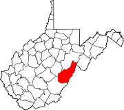
38°33′30″N 79°44′13″W / 38.55833°N 79.73694°W / 38.55833; -79.73694Thornwood is an unincorporated community in Pocahontas County, West Virginia, United States.[1] Thornwood is on the East Fork of the Greenbrier River. US Route 250 passes approximately one-half mile to the south. It is approximately 5 miles (8.0 km) east-northeast of Durbin.[2]
References
- ^ a b c U.S. Geological Survey Geographic Names Information System: Thornwood, West Virginia
- ^ Thomwood, WV, 7.5 Minute Topographic Quadrangle, USGS, 1995
- v
- t
- e
Municipalities and communities of Pocahontas County, West Virginia, United States
County seat: Marlinton

communities
- Beard
- Beard Heights
- Boyer
- Braucher
- Brownsburg
- Buckeye
- Burner
- Burnsides
- Burr
- Campbelltown
- Clawson
- Clover Lick
- Deer Creek
- Denmar
- Dilleys Mill
- Droop
- Dunmore
- Edray
- Frost
- Harter
- Hosterman
- Jacox
- Kennison
- Knapp
- Linwood
- Lobelia
- Locust
- Mace
- May
- Mill Point
- Minnehaha Springs
- Nida
- Nottingham
- Olive
- Onoto
- Raintown
- Raywood
- Rimel
- Seebert
- Sitlington
- Slaty Fork
- Snowshoe
- Spice
- Stillwell
- Stony Bottom
- Thornwood
- Thorny Creek
- Violet
- Walnut
- Wanless
- Warwick
- Watoga
- West Union
- Wildell
- Woodrow
- West Virginia portal
- United States portal
 | This article about a location in Pocahontas County, West Virginia is a stub. You can help Wikipedia by expanding it. |
- v
- t
- e


