Droop, West Virginia
Unincorporated community in West Virginia, United States
38°5′6″N 80°17′5″W / 38.08500°N 80.28472°W / 38.08500; -80.2847224933
Droop is an unincorporated community in Pocahontas County, West Virginia, United States, in the Greenbrier River Valley.
The community takes its name from nearby Droop Mountain.[1] The area lends its name to Droop Mountain Battlefield State Park, site of West Virginia's last significant Civil War battle.[2] The Civilian Conservation Corps (CCC) constructed the park's trails and buildings in the 1930s, as part of Franklin D. Roosevelt's New Deal legislation. Today, a small museum on the park grounds houses Civil War artifacts and discusses the park's CCC history.[3] Bi-annually, the West Virginia Reenactors Association reenacts the Droop Mountain battle.[4]
-
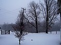 Snowy Day at Droop Mountain
 -
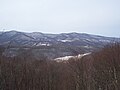 Overlook at the Park


Places of interest
- Droop Mountain Battlefield State Park
- The Civilian Conservation Corps Museum, Civil War History
- Beartown State Park
- Hiking Trails at Both State Parks
- The nearby town of Hillsboro, West Virginia
- The Pearl S. Buck Birthplace
References
- ^ Kenny, Hamill (1945). West Virginia Place Names: Their Origin and Meaning, Including the Nomenclature of the Streams and Mountains. Piedmont, WV: The Place Name Press. p. 214.
- ^ Moyer, Armond; Moyer, Winifred (1958). The origins of unusual place-names. Keystone Pub. Associates. p. 38.
- ^ "Home". droopmountainbattlefield.com.
- ^ "Home". wvra.org.
External links
- v
- t
- e
Municipalities and communities of Pocahontas County, West Virginia, United States
County seat: Marlinton

communities
- Beard
- Beard Heights
- Boyer
- Braucher
- Brownsburg
- Buckeye
- Burner
- Burnsides
- Burr
- Campbelltown
- Clawson
- Clover Lick
- Deer Creek
- Denmar
- Dilleys Mill
- Droop
- Dunmore
- Edray
- Frost
- Harter
- Hosterman
- Jacox
- Kennison
- Knapp
- Linwood
- Lobelia
- Locust
- Mace
- May
- Mill Point
- Minnehaha Springs
- Nida
- Nottingham
- Olive
- Onoto
- Raintown
- Raywood
- Rimel
- Seebert
- Sitlington
- Slaty Fork
- Snowshoe
- Spice
- Stillwell
- Stony Bottom
- Thornwood
- Thorny Creek
- Violet
- Walnut
- Wanless
- Warwick
- Watoga
- West Union
- Wildell
- Woodrow
- West Virginia portal
- United States portal
 | This article about a location in Pocahontas County, West Virginia is a stub. You can help Wikipedia by expanding it. |
- v
- t
- e


