PO postcode area
Postcode area within the United Kingdom
50°47′56″N 1°02′56″W / 50.799°N 1.049°W / 50.799; -1.049
PO
Portsmouth
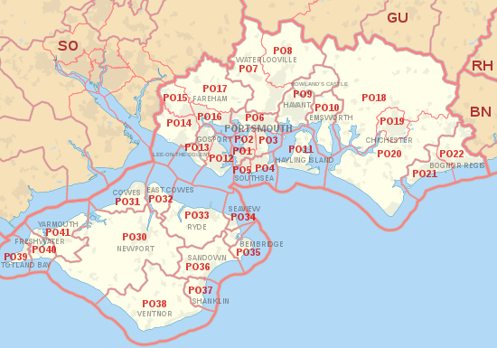
The PO postcode area, also known as the Portsmouth postcode area,[2] is a group of 34 postcode districts in southern England, within 24 post towns. These cover south-east Hampshire (including Portsmouth, Southsea, Havant, Waterlooville, Lee-on-the-Solent, Gosport, Fareham, Rowland's Castle, Emsworth and Hayling Island), southwestern West Sussex (including Chichester and Bognor Regis) and the Isle of Wight.
Coverage
The approximate coverage of the postcode districts:
| Postcode district | Post town | Coverage | Local authority area(s) |
|---|---|---|---|
| PO1 | PORTSMOUTH | Old Portsmouth, Portsea, HMNB Portsmouth, Landport, Buckland, Fratton, Kingston | Portsmouth |
| PO2 | PORTSMOUTH | Kingston, Rudmore, Whale Island, North End, Stamshaw, Tipner, Hilsea | Portsmouth |
| PO3 | PORTSMOUTH | Hilsea (including Anchorage Park), Copnor, Baffins | Portsmouth |
| PO4 | SOUTHSEA | Milton, Eastney, Southsea, Horse Sand Fort | Portsmouth |
| PO5 | SOUTHSEA | Southsea, Somerstown, Spitbank Fort | Portsmouth |
| PO6 | PORTSMOUTH | Farlington, Drayton, Cosham, Wymering, Paulsgrove, Port Solent | Portsmouth |
| PO7 | WATERLOOVILLE | Waterlooville, Denmead, Purbrook | Havant, Winchester |
| PO8 | WATERLOOVILLE | Clanfield, Cowplain, Horndean | East Hampshire, Havant |
| PO9 | HAVANT | Havant | Havant |
| ROWLAND'S CASTLE | Rowland's Castle | East Hampshire, Havant | |
| PO10 | EMSWORTH | Emsworth, Southbourne, Westbourne | Chichester, Havant |
| PO11 | HAYLING ISLAND | Hayling Island | Havant |
| PO12 | GOSPORT | Gosport, Alverstoke, Hardway | Gosport |
| PO13 | GOSPORT | Gosport | Gosport |
| LEE-ON-THE-SOLENT | Lee-on-the-Solent | Gosport | |
| PO14 | FAREHAM | Fareham, Hill Head, Stubbington, Titchfield | Fareham |
| PO15 | FAREHAM | Fareham, Titchfield, Whiteley | Fareham |
| PO16 | FAREHAM | Portchester | Fareham |
| PO17 | FAREHAM | Wickham | Winchester |
| PO18 | CHICHESTER | Bosham, Boxgrove, Eartham, East Dean, Goodwood, Funtington, Nutbourne | Chichester |
| PO19 | CHICHESTER | Chichester, Fishbourne | Chichester |
| PO20 | CHICHESTER | Selsey, West Wittering, East Wittering, Tangmere, Oving, Westergate, Eastergate | Arun, Chichester |
| PO21 | BOGNOR REGIS | Bognor Regis, Aldwick, Pagham | Arun |
| PO22 | BOGNOR REGIS | Bognor Regis, Barnham, Elmer, Felpham, Middleton-on-Sea | Arun |
| PO24 | PORTSMOUTH | Census 2021 (its main national office) | non-geographic |
| PO30 | NEWPORT | Newport | Isle of Wight |
| PO31 | COWES | Cowes, Gurnard | Isle of Wight |
| PO32 | EAST COWES | East Cowes, Whippingham | Isle of Wight |
| PO33 | RYDE | Ryde, St Helens Fort | Isle of Wight |
| PO34 | SEAVIEW | Seaview, No Man's Land Fort | Isle of Wight |
| PO35 | BEMBRIDGE | Bembridge, Whitecliff Bay | Isle of Wight |
| PO36 | SANDOWN | Sandown | Isle of Wight |
| PO37 | SHANKLIN | Shanklin | Isle of Wight |
| PO38 | VENTNOR | Ventnor | Isle of Wight |
| PO39 | TOTLAND BAY | Totland Bay, Alum Bay | Isle of Wight |
| PO40 | FRESHWATER | Freshwater | Isle of Wight |
| PO41 | YARMOUTH | Yarmouth | Isle of Wight |
Map
KML file (edit • help)
Template:Attached KML/PO postcode area
KML is from Wikidata
See also
References
- ^ "ONS Postcode Directory Version Notes" (ZIP). National Statistics Postcode Products. Office for National Statistics. May 2020. Table 2. Retrieved 19 June 2020. Coordinates from mean of unit postcode points, "Code-Point Open". OS OpenData. Ordnance Survey. February 2012. Retrieved 21 April 2012.
- ^ Royal Mail, Address Management Guide, (2004)
External links
- Royal Mail's Postcode Address File
- A quick introduction to Royal Mail's Postcode Address File (PAF)
- v
- t
- e
- AB
- AL
- B
- BA
- BB
- BD
- BH
- BL
- BN
- BR
- BS
- BT
- CA
- CB
- CF
- CH
- CM
- CO
- CR
- CT
- CV
- CW
- DA
- DD
- DE
- DG
- DH
- DL
- DN
- DT
- DY
- E
- EC
- EH
- EN
- EX
- FK
- FY
- G
- GL
- GU
- HA
- HD
- HG
- HP
- HR
- HS
- HU
- HX
- IG
- IP
- IV
- KA
- KT
- KW
- KY
- L
- LA
- LD
- LE
- LL
- LN
- LS
- LU
- M
- ME
- MK
- ML
- N
- NE
- NG
- NN
- NP
- NR
- NW
- OL
- OX
- PA
- PE
- PH
- PL
- PO
- PR
- RG
- RH
- RM
- S
- SA
- SE
- SG
- SK
- SL
- SM
- SN
- SO
- SP
- SR
- SS
- ST
- SW
- SY
- TA
- TD
- TF
- TN
- TQ
- TR
- TS
- TW
- UB
- W
- WA
- WC
- WD
- WF
- WN
- WR
- WS
- WV
- YO
- ZE
- Related UK lists: Postcode districts
- Post towns
- Postal counties
- London postal district


