DH postcode area
Postcode area within the United Kingdom
54°49′34″N 1°37′08″W / 54.826°N 1.619°W / 54.826; -1.619
DH
Durham
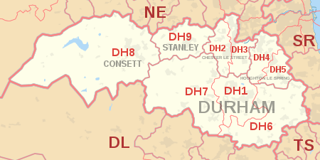
The DH postcode area, also known as the Durham postcode area,[2] is a group of nine postcode districts in north-east England, within five post towns. These cover northern County Durham (including Durham, Chester-le-Street, Consett and Stanley), parts of southern Tyne and Wear (including Houghton-le-Spring) and a small part of southern Northumberland.
Coverage
The approximate coverage of the postcode districts:
| Postcode district | Post town | Coverage | Local authority area(s) |
|---|---|---|---|
| DH1 | DURHAM | Durham | County Durham |
| DH2 | CHESTER LE STREET | Chester-le-Street (west of East Coast Main Line), Ouston, Pelton, Birtley (west of East Coast Main Line) | County Durham, Gateshead |
| DH3 | CHESTER LE STREET | Chester-le-Street (east of East Coast Main Line), Great Lumley, Birtley (east of East Coast Main Line) | County Durham, Gateshead |
| DH4 | HOUGHTON LE SPRING | Houghton-le-Spring (west of A690), Penshaw, Shiney Row, West Rainton | Sunderland, County Durham |
| DH5 | HOUGHTON LE SPRING | Houghton-le-Spring (east of A690), Hetton-le-Hole, East Rainton | Sunderland, County Durham |
| DH6 | DURHAM | South Hetton, Haswell, Shotton Colliery, Ludworth, Shadforth, Sherburn, Littletown, Kelloe, Coxhoe , Bowburn, Cassop, Pittington, Thornley, Wheatley Hill | County Durham |
| DH7 | DURHAM | Brandon, Lanchester, Esh Winning, Burnhope, Langley Park, Sacriston, Ushaw Moor, Brancepeth | County Durham |
| DH8 | CONSETT | Consett, Blackhill, Bridgehill, Shotley Bridge, Leadgate, Delves Lane | County Durham, Northumberland |
| DH9 | STANLEY | Dipton, Stanley, Annfield Plain | County Durham |
| DH97 | DURHAM | HM Passport Office[3] | non-geographic |
| DH98 | DURHAM | BT[3] | non-geographic |
| DH99 | DURHAM | National Savings and Investments[3] | non-geographic |
Map
KML file (edit • help)
Template:Attached KML/DH postcode area
KML is from Wikidata
See also
References
- ^ "ONS Postcode Directory Version Notes" (ZIP). National Statistics Postcode Products. Office for National Statistics. May 2020. Table 2. Retrieved 19 June 2020. Coordinates from mean of unit postcode points, "Code-Point Open". OS OpenData. Ordnance Survey. February 2012. Retrieved 21 April 2012.
- ^ Royal Mail, Address Management Guide, (2004)
- ^ a b c "Non Geographic Codes" (PDF). Royal Mail Address Management Unit. July 2012. Archived from the original (PDF) on 16 September 2012. Retrieved 7 October 2012.
External links
- Royal Mail's Postcode Address File
- A quick introduction to Royal Mail's Postcode Address File (PAF)
- v
- t
- e
- AB
- AL
- B
- BA
- BB
- BD
- BH
- BL
- BN
- BR
- BS
- BT
- CA
- CB
- CF
- CH
- CM
- CO
- CR
- CT
- CV
- CW
- DA
- DD
- DE
- DG
- DH
- DL
- DN
- DT
- DY
- E
- EC
- EH
- EN
- EX
- FK
- FY
- G
- GL
- GU
- HA
- HD
- HG
- HP
- HR
- HS
- HU
- HX
- IG
- IP
- IV
- KA
- KT
- KW
- KY
- L
- LA
- LD
- LE
- LL
- LN
- LS
- LU
- M
- ME
- MK
- ML
- N
- NE
- NG
- NN
- NP
- NR
- NW
- OL
- OX
- PA
- PE
- PH
- PL
- PO
- PR
- RG
- RH
- RM
- S
- SA
- SE
- SG
- SK
- SL
- SM
- SN
- SO
- SP
- SR
- SS
- ST
- SW
- SY
- TA
- TD
- TF
- TN
- TQ
- TR
- TS
- TW
- UB
- W
- WA
- WC
- WD
- WF
- WN
- WR
- WS
- WV
- YO
- ZE
- Related UK lists: Postcode districts
- Post towns
- Postal counties
- London postal district


