Konar Dam
Dam in Jharkhand, India
23°56′28″N 85°46′30″E / 23.94111°N 85.77500°E / 23.94111; 85.77500Konar Dam is the second of the four multi-purpose dams included in the first phase of the Damodar Valley Corporation. It was constructed across the Konar River, a tributary of the Damodar River in Hazaribagh district in the Indian state of Jharkhand and opened in 1955.[1] The place has been developed as a recreational spot.[2]
Geography


15km
10miles
10miles

B
I
H
A
R
Mohana
River
River
Damodar
River
River
Bokaro
River
River
Konar
River
River
Barsoti River
Barakar River
CCL
Hazaribagh Area
Hazaribagh Area

CCL Argada Area
CCL Barka
Sayal Area
Sayal Area
CCL Amrapali
& Chandragupta Area
& Chandragupta Area
Surajkund hot spring
HS
Konar
Dam
Dam
D
Hazaribagh
Wildlife Sanctuary
Wildlife Sanctuary
T
Urimari
CT
Religara
CT
Meru
CT
Konra
CT
Gidi
CTV
Dari
CT
Cherra
CT
Chauparan
CT
Charhi
CT
Bishnugarh
CT
Barhi
CT
Hazaribagh
M
Tati Jhariya
R
Padma
R
Nagar Barsot
R
Khapriaon
R
Keredari
R
Katkamsandi
R
Katkamdag
R
Ichak
R
Gorhar
R
Daru
R
Churchu
R
Chalkusha
R
Barkatha
R
Barkagaon
R
Cities, towns and locations in Hazaribagh district in North Chotanagpur Division
Some census towns and locations around Hazaribagh city have been shown in the Hazaribagh City map
M: municipality, CT: census town, R: rural/ urban centre, T: tourist centre, D: dam, HS: hot spring
Owing to space constraints in the small map, the actual locations in a larger map may vary slightly
Some census towns and locations around Hazaribagh city have been shown in the Hazaribagh City map
M: municipality, CT: census town, R: rural/ urban centre, T: tourist centre, D: dam, HS: hot spring
Owing to space constraints in the small map, the actual locations in a larger map may vary slightly
Location
Konar Dam is located at 23°56′28″N 85°46′30″E / 23.94111°N 85.77500°E / 23.94111; 85.77500.
Konar Dam is 4,535 metres (14,879 ft) long and 48.77 metres (160.0 ft) high. When full, the reservoir covers an area of 27.92 km2.[3]
Note: The map alongside presents some of the notable locations in the district. All places marked in the map are linked in the larger full screen map.
DVC overview

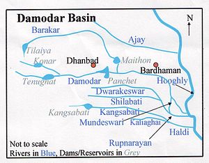
As a result of the catastrophic flood of 1943, the Governor of Bengal appointed the Damodar Flood enquiry committee to suggest remedial measures.Damodar Valley Corporation came into existence in 1948 for development and management of the basin as a whole. Voorduin envisaged the construction of eight dams and a barrage, but it was later decided to have only four dams, at Tilaiya, Konar, Maithon and Panchet, and Durgapur Barrage.[4]
The first dam was built across the Barakar River at Tilaiya and inaugurated in 1953. The second dam across the Konar River was inaugurated in 1955. The third dam across the Barakar at Maithon was inaugurated in 1957. The fourth dam across the Damodar at Panchet was inaugurated in 1959.[5]
Transport
Konar Dam is located 41 kilometres (25 mi) south-east of Hazaribagh.[1]
References
- ^ a b "Konar Dam". india9.com. Retrieved 2010-04-17.
- ^ Dr. B.R. Kishore, Dr. Shiv Sharma (2008). India - A Travel Guide. Diamond Pocket Books (P) Ltd. p. 302. ISBN 9788128400674.
- ^ "DVC". Konar. DVC. Archived from the original on 2007-02-10. Retrieved 2010-04-17.
- ^ Sharad K. Jain; Pushpendra K. Agarwal; Vijay P. Singh (16 May 2007). Hydrology and Water Resources of India. Springer. ISBN 9781402051807. Retrieved 2010-06-06.
{{cite book}}:|work=ignored (help) - ^ "Damodar Valley Corporation". Dams and Barrages. DVC. Archived from the original on 2010-04-29. Retrieved 2010-06-06.
External links
Wikimedia Commons has media related to Konar Dam.
| External videos | |
|---|---|
 Konar Dam Konar Dam |
- v
- t
- e
Hydrography of Jharkhand
| Damodar basin | |
|---|---|
| Subarnarekha basin | |
| Brahmani basin | |
| Son basin |
|
| Others: north flowing | |
| Others: east flowing |
|
| Others: south-east flowing |


