Templeogue
 |
| Państwo |  Irlandia Irlandia
|
| Hrabstwo | Dublin Południowy |
Populacja (2006)
• liczba ludności |
17 600
|
| Kod pocztowy | D6W |
Położenie na mapie Irlandii |
 53°17′N 6°18′W/53,283333 -6,300000 53°17′N 6°18′W/53,283333 -6,300000 |
 | Multimedia w Wikimedia Commons | |
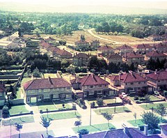
Templeogue (irl. Teach Mealóg) – przedmieście Dublina, stolicy Irlandii, w hrabstwie Dublin Południowy, liczy 17 600 mieszkańców (2006)[1].
Przypisy
- ↑ Census 2006 Preliminary Report. [dostęp 2011-12-17]. (ang.).
Dzielnice Dublina
| Northside | - Artane
- Ashtown
- Baldoyle
- Balgriffin
- Ballybough
- Ballygall
- Ballymun
- Bayside
- Beaumont
- Blanchardstown
- Broadstone
- Cabra
- Castleknock
- Clonee
- Clongriffin
- Clonsilla
- Clontarf
- Coolock
- Corduff
- Darndale
- Dollymount
- Donaghmede
- Donnycarney
- Drumcondra
- East Wall
- Fairview
- Finglas
- Glasnevin
- Grangegorman
- Harmonstown
- Howth
- Kilbarrack
- Killester
- Marino
- Mulhuddart
- North Strand
- North Wall
- Ongar
- Oxmantown
- Phibsboro
- Poppintree
- Priorswood
- Raheny
- Santry
- Sheriff Street
- Smithfield
- Stoneybatter
- Sutton
- Whitehall
|
|---|
| Southside | |
|---|


 53°17′N 6°18′W/53,283333 -6,300000


