 Belizes distrikter.
 Belize er delt inn i 6 distrikter (districts). Distriktene er videre delt opp i 31 constituencies.
Distrikter i Belize | Distrikt | Senter | Areal (km²)[1] | Innbyggertall 2010[2] | Kart |
| Belize | Belize City | 4 204 | 89 247 |  |
| Cayo | San Ignacio | 5 338 | 72 899 |  |
| Corozal | Corozal Town | 1 860 | 40 354 |  |
| Orange Walk | Orange Walk Town | 4 737 | 45 419 |  |
| Stann Creek | Dangriga | 2 176 | 32 166 |  |
| Toledo | Punta Gorda | 4 649 | 30 538 | 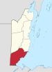 |
| Totalt | Belmopan | 22 964 | 312 698 | |
Referanser
- ^ GeoHive; Belize, administrative units Arkivert 30. oktober 2010 hos Wayback Machine. Besøkt 10. desember 2012.
- ^ Statistical Insitute of Belize - Official Release of the main results of the 2010 Population and Housing Census Besøkt 10. desember 2012.
Belizes distrikter |
|---|
Belize · Cayo · Corozal · Orange Walk · Stann Creek · Toledo | |
ISO 3166-2:BZ |
Øverste administrative nivå etter stat i Nord-Amerika |
|---|
- Antigua og Barbuda
- Bahamas
- Barbados
- Belize
- Canada
- Costa Rica
- Cuba
- Dominica
- Den dominikanske republikk
- El Salvador
- Grenada
- Guatemala
- Haiti
- Honduras
- Jamaica
- Mexico
- Nicaragua
- Panama
- St. Kitts og Nevis
- St. Lucia
- St. Vincent og Grenadinene
- Trinidad og Tobago
- USA
|
Autoritetsdata


