Lugny-Bourbonnais
Plaats in Frankrijk  | |||
|---|---|---|---|
  | |||
| Situering | |||
| Regio | Centre-Val de Loire | ||
| Departement | Cher (18) | ||
| Arrondissement | Saint-Amand-Montrond | ||
| Kanton | La Guerche-sur-l'Aubois | ||
| Gemeente | Osmery | ||
| Coördinaten | 46° 56′ NB, 2° 42′ OL | ||
| Overig | |||
| Postcode(s) | 18350 | ||
| INSEE-code | 18131 | ||
| Foto's | |||
 | |||
| Kapel van Sint Clara | |||
| |||

Lugny-Bourbonnais is een plaats en voormalige gemeente in het Franse departement Cher in de regio Centre-Val de Loire en telt 33 inwoners (2009). De plaats maakt deel uit van het arrondissement Saint-Amand-Montrond. Op 1 januari 2024 is Lugny-Bourbonnais opgegaan in de gemeente Osmery.
Geografie
De oppervlakte van Lugny-Bourbonnais bedraagt 5,5 km², de bevolkingsdichtheid is dus 6 inwoners per km².
De onderstaande kaart toont de ligging van Lugny-Bourbonnais met de belangrijkste infrastructuur en aangrenzende gemeenten.
 |
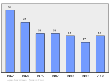
Demografie
Onderstaande figuur toont het verloop van het inwonertal (bron: INSEE-tellingen).
Externe links
- (fr) Statistische informatie op de website van INSEE
Bronnen, noten en/of referenties


