Le Grau-du-Roi
Gemeente in Frankrijk  | |||
|---|---|---|---|
 | |||
  | |||
| Situering | |||
| Regio | Occitanie | ||
| Departement | Gard (30) | ||
| Arrondissement | Nîmes | ||
| Kanton | Aigues-Mortes | ||
| Coördinaten | 43° 32′ NB, 4° 9′ OL | ||
| Algemeen | |||
| Oppervlakte | 54,73 km² | ||
| Inwoners (1 januari 2021) | 8.438[1] (154 inw./km²) | ||
| Hoogte | 0 - 5 m | ||
| Burgemeester | Robert Crauste (april 2014) | ||
| Overig | |||
| Postcode | 30240 | ||
| INSEE-code | 30133 | ||
| Foto's | |||
 | |||
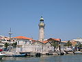
| Oude vuurtoren (buiten gebruik) | |||
| |||

Le Grau-du-Roi is een gemeente in het Franse departement Gard (regio Occitanie). De plaats maakt deel uit van het arrondissement Nîmes. Le Grau-du-Roi telde op 1 januari 2021 8.438[1] inwoners.
Geografie
De oppervlakte van Le Grau-du-Roi bedroeg op 1 januari 2021 54,73 vierkante kilometer; de bevolkingsdichtheid was toen 154,2 inwoners per km².

Demografie
Onderstaande figuur toont het verloop van het inwonertal (bron: INSEE-tellingen).

Afbeeldingen
-
 De (vissers)haven van Le Grau-du-Roi.
 -
 Zicht op Le Grau-du-Roi vanaf het strand.
 -
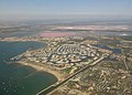 Gezicht op Port Camargue


Externe links
- Informatie over Le Grau-du-Roi
- (fr) Statistische informatie op de website van INSEE
Bronnen, noten en/of referenties
- ↑ a b Populations légales 2021.
Mediabestanden
Zie de categorie Le Grau-du-Roi van Wikimedia Commons voor mediabestanden over dit onderwerp.


