L'Hôpital (Moselle)
Gemeente in Frankrijk  | |||
|---|---|---|---|
 | |||
  | |||
| Situering | |||
| Regio | Grand Est | ||
| Departement | Moselle (57) | ||
| Arrondissement | Forbach-Boulay-Moselle | ||
| Kanton | Saint-Avold | ||
| Coördinaten | 49° 10′ NB, 6° 44′ OL | ||
| Algemeen | |||
| Oppervlakte | 3,99 km² | ||
| Inwoners (1 januari 2021) | 5.182[1] (1.299 inw./km²) | ||
| Hoogte | 220 - 300 m | ||
| Overig | |||
| Postcode | 57490 | ||
| INSEE-code | 57336 | ||
| Website | Officiële website | ||
| Foto's | |||
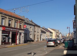 | |||
| Rue du maréchal Foch | |||
| |||

L'Hôpital (Duits: Spittel in Lothringen) is een gemeente in het Franse departement Moselle (regio Grand Est). De oppervlakte bedraagt 3,99 km², de bevolkingsdichtheid is 1501 inwoners per km². L'Hôpital 1 januari 2021 5.182[1] inwoners.
Geografie
De oppervlakte van L'Hôpital bedroeg op 1 januari 2021 3,99 vierkante kilometer; de bevolkingsdichtheid was toen 1.298,7 inwoners per km².

Demografie
Onderstaande figuur toont het verloop van het inwonertal (bron: INSEE-tellingen).

Bronnen, noten en/of referenties
- ↑ a b Populations légales 2021.
Mediabestanden
Zie de categorie L'Hôpital (Moselle) van Wikimedia Commons voor mediabestanden over dit onderwerp.
Gemeenten in het kanton Saint-Avold
Altviller · Carling · Diesen · Folschviller · L'Hôpital · Lachambre · Macheren · Porcelette · Saint-Avold · Valmont


