Southam
 Disambiguazione – Se stai cercando altri significati, vedi Southam (disambigua).
Questa voce sull'argomento centri abitati del Warwickshire è solo un abbozzo.
Contribuisci a migliorarla secondo le convenzioni di Wikipedia.
| Southam parrocchia civile | |
|---|---|
 | |
| Localizzazione | |
| Stato |  Regno Unito Regno Unito Inghilterra Inghilterra |
| Regione | Midlands Occidentali |
| Contea |  Warwickshire Warwickshire |
| Distretto | Stratford-on-Avon |
| Territorio | |
| Coordinate | 52°15′07.2″N 1°23′24″W52°15′07.2″N, 1°23′24″W (Southam) |
| Superficie | 12,62 km² |
| Abitanti | 6 509 (2001) |
| Densità | 515,81 ab./km² |
| Altre informazioni | |
| Cod. postale | CV47 |
| Prefisso | 01926 |
| Fuso orario | UTC+0 |
| Cartografia | |
  Southam | |
| Modifica dati su Wikidata · Manuale | |
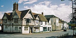
Southam è un paese di 6.509 abitanti della contea del Warwickshire, in Inghilterra.
Altri progetti
Altri progetti
- Wikimedia Commons
 Wikimedia Commons contiene immagini o altri file su Southam
V · D · M | |
|---|---|
| Distretti o Borough | Borough of North Warwickshire · Borough of Nuneaton and Bedworth · Borough of Rugby · District of Stratford-on-Avon · District of Warwick |
| Città e paesi | Alcester · Atherstone · Bedworth · Coleshill · Henley-in-Arden · Kenilworth · Leamington Spa · Nuneaton · Rugby · Shipston-on-Stour · Southam · Stratford-upon-Avon · Warwick · Whitnash Parrocchie civili del Warwickshire |
| Controllo di autorità | J9U (EN, HE) 987007557661405171 |
|---|
 Portale Regno Unito: accedi alle voci di Wikipedia che parlano del Regno Unito


