Wolchulsan
Mountain in South Korea
You can help expand this article with text translated from the corresponding article in Korean. (March 2022) Click [show] for important translation instructions.
- Machine translation, like DeepL or Google Translate, is a useful starting point for translations, but translators must revise errors as necessary and confirm that the translation is accurate, rather than simply copy-pasting machine-translated text into the English Wikipedia.
- Do not translate text that appears unreliable or low-quality. If possible, verify the text with references provided in the foreign-language article.
- You must provide copyright attribution in the edit summary accompanying your translation by providing an interlanguage link to the source of your translation. A model attribution edit summary is
Content in this edit is translated from the existing Korean Wikipedia article at [[:ko:월출산]]; see its history for attribution. - You may also add the template
{{Translated|ko|월출산}}to the talk page. - For more guidance, see Wikipedia:Translation.
Wolchulsan (월출산) is a mountain located in South Jeolla province, South Korea; and spans both Gangjin and Yeongam counties. At its peak, Cheonhwangbong, it rises to 808.7 meters, making it the highest point in Gangjin County.
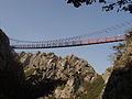
It lies in a national park of the same name. Wolchulsan National Park is the smallest national park of South Korea, with an area of 41 square kilometres (16 sq mi). A notable feature of the mountain is the "Cloud Bridge" (구름다리) a small suspension bridge that spans two peaks.
-
 Wolchulsan and its "Cloud Bridge"
 -
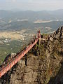 Cloud Bridge
 -
 Cloud Bridge


External links
- Wolchulsan National Park
References
- http://english.knps.or.kr/Knp/Wolchulsan/Intro/Introduction.aspx


