Washington Crossing, Pennsylvania
Unincorporated community in Pennsylvania, United States
40°17′36″N 74°52′14″W / 40.29333°N 74.87056°W / 40.29333; -74.8705618977
Washington Crossing, Pennsylvania is an unincorporated village located in Upper Makefield Township, Pennsylvania, United States. Formerly known as "Taylorsville," it is most famous for being the western launch point for George Washington's crossing of the Delaware River on the night of December 25–26, 1776 during the Revolutionary War.
The headquarters of Washington Crossing Historic Park is also located in Washington Crossing, Pennsylvania. The village is connected by Washington Crossing Bridge with Washington Crossing, New Jersey, which is located on the eastern side of the Delaware River.
Geography
The Delaware Canal, a 60-mile (97 km) long towpath from Easton to Bristol, runs through Washington Crossing Historic Park.
Special events
The town also participates in special events, such as a reenactment of Washington's nighttime crossing each year.[2] Its ZIP Code is 18977.
Points of interest
Gallery
-
 Washington Crossing Inn
 -
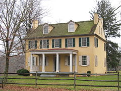 Mahlon K. Taylor house
 -


References
- ^ "Washington Crossing". Geographic Names Information System. United States Geological Survey, United States Department of the Interior.
- ^ "Cross With Us". Washington Crossing Historic Park. November 11, 2014.
External links
Wikimedia Commons has media related to Washington Crossing, Pennsylvania.
- v
- t
- e
Municipalities and communities of Bucks County, Pennsylvania, United States
County seat: Doylestown

- Bedminster
- Bensalem
- Bridgeton
- Bristol
- Buckingham
- Doylestown
- Durham
- East Rockhill
- Falls
- Haycock
- Hilltown
- Lower Makefield
- Lower Southampton
- Middletown
- Milford
- New Britain
- Newtown
- Nockamixon
- Northampton
- Plumstead
- Richland
- Solebury
- Springfield
- Tinicum
- Upper Makefield
- Upper Southampton
- Warminster
- Warrington
- Warwick
- West Rockhill
- Wrightstown
communities
- Almont
- Amity
- Andalusia
- Applebachsville
- Aquetong
- Argus
- Bedminster
- Brick Tavern
- Blooming Glen
- Buckingham
- Bucksville
- Carversville
- Centre Bridge
- Danboro
- Dolington
- Durham
- Elephant
- Erwinna
- Eureka‡
- Fallsington
- Ferndale
- Finland
- Forest Grove
- Fountainville
- Furlong
- Gallows Hill
- Gardenville
- Geryville‡
- Hagersville
- Harrow
- Hartsville
- Highton
- Hilltown
- Hinkletown
- Holicong
- Holland
- Hood
- Jamison
- Kintnersville
- Kulps Corner
- Lahaska
- Line Lexington‡
- Lodi
- Loux Corner (Hilltown)
- Lumberville
- Maple Beach
- Mechanicsville
- Mount Pleasant
- Neshaminy
- Neshaminy Falls
- Newville
- Ottsville
- Oxford Valley
- Penns Park
- Pineville
- Pipersville
- Pleasant Valley
- Point Pleasant
- Revere
- Rushland
- Shelly
- Solebury
- Southampton
- Springtown
- Uhlerstown
- Unionville‡
- Upper Black Eddy
- Washington Crossing
- White Horse
- Wrightstown
- Wycombe
- Zionhill
‡This populated place also has portions in an adjacent county or counties
- Pennsylvania portal
- United States portal
Authority control databases | |
|---|---|
| International |
|
| National |
|


