Waiuku River
River in the Auckland Region, New Zealand
37°14′59″S 174°43′55″E / 37.24959°S 174.73183°E / -37.24959; 174.73183
• coordinates
The Waiuku River, also known as the Waiuku Estuary, is an estuarial arm of the Manukau Harbour, near the town of Waiuku, south-west of Auckland. It joins the harbour at the south west and extends south for 12 kilometres (7 mi), having its head close to the town of Waiuku.[1]
Gallery
-
 Buildings along the edge of the Waiuku River (circa 1911)
 -
 The Waiuku River at low tide in 2000
 -
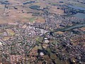 Southern end of the Waiuku River, as it meets the township of Waiuku


References
- ^ "Waiuku River". New Zealand Gazetteer. Retrieved 8 November 2023.
- v
- t
- e
Waiuku Subdivision - Franklin Local Board Area, Auckland, New Zealand
- Glenbrook
- Glenbrook Beach
- Grahams Beach
- Matakawau Point
- Pollok
- Waiuku
Waiuku River at Wikipedia's sister projects:
 Media from Commons
 Data from Wikidata
This article about a river in the Auckland Region is a stub. You can help Wikipedia by expanding it. |
- v
- t
- e


