Smithton Township, St. Clair County, Illinois
Township in Illinois, United States
Smithton Township | |
|---|---|
Township | |
 Location in St. Clair County | |
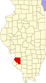 St. Clair County's location in Illinois | |
| Country |  United States United States |
| State |  Illinois Illinois |
| County |  St. Clair St. Clair |
| Established | November 6, 1883 |
| Area | |
| • Total | 32.91 sq mi (85.2 km2) |
| • Land | 32.28 sq mi (83.6 km2) |
| • Water | 0.63 sq mi (1.6 km2) 1.91% |
| Population (2010) | |
| • Estimate (2016)[1] | 4,225 |
| • Density | 132.4/sq mi (51.1/km2) |
| Time zone | UTC-6 (CST) |
| • Summer (DST) | UTC-5 (CDT) |
| FIPS code | 17-163-70265 |
Smithton Township (Township 1 South, Range 8 West) is located in St. Clair County, Illinois. As of the 2010 census, its population was 4,275 and it contained 1,684 housing units.[2]
Geography
According to the 2010 census, the township has a total area of 32.91 square miles (85.2 km2), of which 32.28 square miles (83.6 km2) (or 98.09%) is land and 0.63 square miles (1.6 km2) (or 1.91%) is water.[2]
Demographics
| Census | Pop. | Note | %± |
|---|---|---|---|
| 2016 (est.) | 4,225 | [1] | |
| U.S. Decennial Census[3] | |||
Elected Officials
The current Members of the Smithton Township Board are Supervisor William F. Weber; Trustees Donald Barkau, Mark Rodriguez, Neil Espenschied, Quentin Grommet; Highway Commissioner Paul Reinneck; Clerk Troy L. Herring.
All seven Smithton Township Officials are serving a four-year term that ends in May, 2025.
References
- ^ a b "Population and Housing Unit Estimates". Retrieved June 9, 2017.
- ^ a b "Population, Housing Units, Area, and Density: 2010 - County -- County Subdivision and Place -- 2010 Census Summary File 1". United States Census. Archived from the original on February 12, 2020. Retrieved May 28, 2013.
- ^ "Census of Population and Housing". Census.gov. Retrieved June 4, 2016.
External links
- City-data.com
- St. Clair County Official Site
- Illinois State Archives
- v
- t
- e
Municipalities and communities of St. Clair County, Illinois, United States
County seat: Belleville
- Belleville
- Cahokia Heights
- Collinsville‡
- Columbia‡
- East St. Louis
- Fairview Heights
- Lebanon
- Madison‡
- Mascoutah
- O'Fallon

unincorporated
communities
‡This populated place also has portions in an adjacent county or counties
- Illinois portal
- United States portal

38°26′33″N 89°59′15″W / 38.44250°N 89.98750°W / 38.44250; -89.98750
 | This St. Clair County, Illinois location article is a stub. You can help Wikipedia by expanding it. |
- v
- t
- e


