Rutherglen Town Hall
Municipal building in Rutherglen, Scotland
55°49′43″N 4°12′52″W / 55.8286°N 4.2144°W / 55.8286; -4.2144
Listed Building – Category A
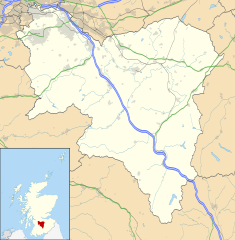

Shown in South Lanarkshire
Rutherglen Town Hall is a municipal facility on the north side of Main Street in Rutherglen, Scotland. The town hall, which was the headquarters of Rutherglen Burgh Council, is a Category A listed building.[1]
History
The current building was commissioned to replace an earlier town hall, known latterly as "the old jail", which had been completed in 1766.[2] After significant population expansion associated with the growth in the mining industry, civic leaders decided to procure a new town hall although the two structures coexisted almost alongside each other until 1900.[2]
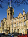
The foundation stone for the new building was laid by with full masonic honours by Sir Archibald Alison on 16 July 1861.[2] It was designed by Charles Wilson in the Scottish baronial style and completed in 1862.[1] The design involved an asymmetrical frontage of five bays facing Main Street; the left hand section of four bays featured four round-headed windows on the ground floor and a large oriel window on the first floor with a gable above; the right hand bay featured a doorway with a gable head and a prominent 110 feet (34 m) four-sided asymmetric clock tower with corner bartizans.[1] On either side of the oriel window carved panels were erected, one with "circa David I 1126" and the other with "circa William I 1189", as reminders of the dates when ancient privileges were awarded to the town.[2] The building was extended to the east by an extra eight bays to the designs of Robert Dalgleish and John Thomson in 1877[3] and an iron canopy was erected outside the doorway in 1902.[1] Internally, the principal rooms were the council chambers, a courtroom and a public hall.[2]
The town hall was the seat of government of Rutherglen Burgh Council until it was gutted during a conversion to offices in 1967,[3] and became surplus to requirements after the town was absorbed into Glasgow District under the Local Government (Scotland) Act 1973 in May 1975.[4] It was then closed to the public in the 1980s and fell into a state of disrepair.[5] The building was refurbished and extended with the addition of a twin-level glass atrium to the rear at a cost of £12 million (supported by Historic Scotland and the Heritage Lottery Fund for Scotland) in 2004.[6][7] It continues to be used as a venue for weddings, theatrical performances and exhibitions,[8][9] while still providing some local services such as the Licensing and Registration Office.[10]
-
 Elevated view of Main Street from the east with the tower of the town hall prominent
 -
 Exterior detail of the original Grand Hall
 -
 View from south showing 1877 east extension
 -
 View of the clock tower


Rutherglen's other Category A listed buildings are located very near to the town hall: a medieval clock tower and churchyard [de] is situated immediately to the west, while St Columbkille's RC Church [de] (completed in 1940) is directly opposite on the other side of Main Street. There are also several Category B structures in close proximity (library, Old Parish Church, statue of Dr Gorman, tenement adjoining the town hall's east wing).[7][11]
See also
- List of Category A listed buildings in South Lanarkshire
- List of city and town halls in Scotland
- List of listed buildings in Rutherglen, South Lanarkshire
- List of theatres in Scotland
References
- ^ a b c d Historic Environment Scotland. "131, 139 Main Street, Rutherglen, District Council offices (originally town hall) (Category A Listed Building) (LB33564)". Retrieved 20 April 2020.
- ^ a b c d e Shearer, Ross (1926). "Rutherglen Lore" (PDF). Ruglonians Society. p. 161. Retrieved 15 November 2020.
- ^ a b "Rutherglen Town Hall". Dictionary of Scottish Architects. Retrieved 20 April 2020.
- ^ "Local Government (Scotland) Act 1973". Legislation.gov.uk. Retrieved 16 April 2020.
- ^ "How Rutherglen Town Hall was brought back to its best". Daily Record. 4 March 2015. Retrieved 20 April 2020.
- ^ "Portfolio: Rutherglen Town Hall". Honeyman Jack & Robertson Chartered Architects. Retrieved 20 April 2020.
- ^ a b "Rutherglen Conservation Area: Character Appraisal" (PDF). South Lanarkshire Council. 2008. Retrieved 15 November 2020.
- ^ "Rutherglen Town Hall". South Lanarkshire Leisure and Culture. Retrieved 20 April 2020.
- ^ "Rutherglen Town Hall: 10 Reasons To Choose This Scottish Wedding Venue". White Rose Wedding Venues. Retrieved 15 November 2020.
- ^ "Licensing and Registration Office – Rutherglen". South Lanarkshire Council. Retrieved 20 April 2020.
- ^ "Listed Buildings in Rutherglen Central and North Ward, South Lanarkshire". British Listed Buildings. Retrieved 15 November 2020.
External links
 Media related to Rutherglen Town Hall at Wikimedia Commons
- v
- t
- e
Rutherglen and Cambuslang
- Burnside
- Cambuslang Park
- Cathkin Braes
- Cathkin High School
- Clydebridge Steelworks
- Coats Park
- Cuningar Loop
- Drumsagard
- Eastfield
- Fernbrae Meadows
- Fernhill
- Fernhill School
- Fire and Rescue Training Centre
- Gilbertfield Castle
- Halfway
- Holmhills Park
- Kirkhill
- New Southcroft Park
- Newton
- Overtoun Park
- Rutherglen High School
- Rutherglen Town Hall
- Shawfield
- Shawfield Stadium
- Somervell Park
- Stonelaw High School
- Trinity High School
- Westburn
- Whitlawburn
- In vicinity:
- Athletes' Village
- Blantyre
- Carmunnock
- Carmyle
- Castlemilk
- Croftfoot
- Dalmarnock
- King's Park
- Oatlands
- Toryglen
- Uddingston
- Rail stations:
- Burnside
- Cambuslang
- Croftfoot
- Kirkhill
- Newton
- Rutherglen


