Puerto Rico Highway 42
Highway in Puerto Rico
Major junctions
 PR-39 in Santurce
 PR-2 in Santurce
←  PR-41 PR-41 | →  PR-47 PR-47 |
Puerto Rico Highway 42 (PR-42) is an urban road in Santurce. This is a short road that connects from the PR-39 (Calle Cerra) to Calle Lafayette and intersects with PR-2. It is parallel to the PR-35 (Avenida Manuel Fernández Juncos) and PR-25 (Avenida Juan Ponce de León). This road is called Calle Las Palmas.[3]
Major intersections
The entire route is located in Santurce, San Juan.
-
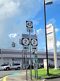 PR-42 at its junction with PR-2 in Santurce

| km[2] | mi | Destinations | Notes | ||
|---|---|---|---|---|---|
| 0.0 | 0.0 |   PR-39 (Calle Cerra) to PR-1 PR-39 (Calle Cerra) to PR-1 | Western terminus of PR-42; no right turn | ||
| 0.5 | 0.31 | PR-2 (Calle Labra) | Calle Labra is also known as Avenida Roberto H. Todd | ||
| 1.0 | 0.62 | Calle Lafayette | Eastern terminus of PR-42 | ||
1.000 mi = 1.609 km; 1.000 km = 0.621 mi
| |||||
See also
 Puerto Rico portal
 U.S. Roads portal

References
- ^ "Calle Las Palmas". Mapio.net. Retrieved 28 February 2020.
- ^ a b Google (28 February 2020). "PR-42" (Map). Google Maps. Google. Retrieved 28 February 2020.
- ^ National Geographic Maps (2011). Puerto Rico (Map). 1:125,000. Adventure Map (Book 3107). Evergreen, Colorado: National Geographic Maps. ISBN 978-1566955188. OCLC 756511572.
External links
 Media related to Puerto Rico Highway 42 at Wikimedia Commons
- v
- t
- e
 | This Puerto Rico road-related article is a stub. You can help Wikipedia by expanding it. |
- v
- t
- e


