Parsau
Municipality in Lower Saxony, Germany

Coat of arms
Location of Parsau within Gifhorn district

52°32′N 10°52′E / 52.533°N 10.867°E / 52.533; 10.867
(2022-12-31)[1]
38470
Parsau is a municipality in the district of Gifhorn, in Lower Saxony, Germany. The Municipality Parsau includes the villages of Ahnebeck, Croya, Kaiserwinnkel and Parsau.
-
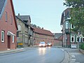 The main street
 -
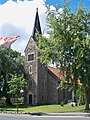 The Lutheran church
 -
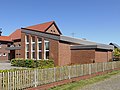 The Baptist church
 -
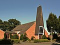 The catholic church
 -
 The former station


References
- ^ "LSN-Online Regionaldatenbank, Tabelle A100001G: Fortschreibung des Bevölkerungsstandes, Stand 31. Dezember 2022" (in German). Landesamt für Statistik Niedersachsen.
- v
- t
- e
Towns and municipalities in Gifhorn (district)
- Adenbüttel
- Barwedel
- Bergfeld
- Bokensdorf
- Brome
- Calberlah
- Dedelstorf
- Didderse
- Ehra-Lessien
- Gifhorn
- Groß Oesingen
- Hankensbüttel
- Hillerse
- Isenbüttel
- Jembke
- Leiferde
- Meine
- Meinersen
- Müden (Aller)
- Obernholz
- Osloß
- Parsau
- Ribbesbüttel
- Rötgesbüttel
- Rühen
- Sassenburg
- Schönewörde
- Schwülper
- Sprakensehl
- Steinhorst
- Tappenbeck
- Tiddische
- Tülau
- Ummern
- Vordorf
- Wagenhoff
- Wahrenholz
- Wasbüttel
- Wesendorf
- Westerbeck (Sassenburg)
- Weyhausen
- Wittingen

Authority control databases | |
|---|---|
| International |
|
| National |
|
| Geographic |
|
 | This Gifhorn district location article is a stub. You can help Wikipedia by expanding it. |
- v
- t
- e


