National Register of Historic Places listings in Loudoun County, Virginia

This is a list of the National Register of Historic Places listings in Loudoun County, Virginia.
This is intended to be a complete list of the properties and districts on the National Register of Historic Places in Loudoun County, Virginia, United States. The locations of National Register properties and districts for which the latitude and longitude coordinates are included below, may be seen in an online map.[1]
There are 98 properties and districts listed on the National Register in the county, including 6 National Historic Landmarks. Another property was once listed but has been removed.
This National Park Service list is complete through NPS recent listings posted June 14, 2024.[2]
Map all coordinates using OpenStreetMap
Download coordinates as:
- KML
- GPX (all coordinates)
- GPX (primary coordinates)
- GPX (secondary coordinates)
Current listings
| [3] | Name on the Register[4] | Image | Date listed[5] | Location | City or town | Description |
|---|---|---|---|---|---|---|
| 1 | Aldie Mill Historic District |  | September 15, 1970 (#70000806) | Both sides of U.S. Route 50 from east of Tail Race Rd. to west of Meetinghouse Ln. 38°58′31″N 77°38′28″W / 38.975278°N 77.641111°W / 38.975278; -77.641111 (Aldie Mill Historic District) | Aldie | |
| 2 | Arcola Elementary School |  | June 5, 2013 (#13000363) | 24244 Gum Spring Rd. 38°56′52″N 77°32′14″W / 38.947778°N 77.537222°W / 38.947778; -77.537222 (Arcola Elementary School) | Arcola | |
| 3 | Arcola Slave Quarters |  | November 26, 2008 (#08001113) | 24837 Evergreen Mills Rd. 38°56′49″N 77°31′43″W / 38.946833°N 77.528611°W / 38.946833; -77.528611 (Arcola Slave Quarters) | Arcola | |
| 4 | Ashburn Presbyterian Church | 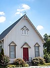 | August 5, 1999 (#99000962) | 20962 Ashburn Rd. 39°02′19″N 77°29′08″W / 39.038611°N 77.485556°W / 39.038611; -77.485556 (Ashburn Presbyterian Church) | Leesburg | |
| 5 | Ball's Bluff Battlefield Historic District and National Cemetery |  | April 27, 1984 (#84003880) | Ball's Bluff 39°07′55″N 77°31′39″W / 39.131944°N 77.527500°W / 39.131944; -77.527500 (Ball's Bluff Battlefield Historic District and National Cemetery) | Leesburg | |
| 6 | Bear's Den Rural Historic District |  | May 14, 2009 (#08001112) | Generally runs along both sides of the ridge along parts of Raven Rocks and Blue Ridge Mountain Rds. 39°06′32″N 77°50′54″W / 39.108889°N 77.848333°W / 39.108889; -77.848333 (Bear's Den Rural Historic District) | Bluemont | |
| 7 | Belmont |  | February 8, 1980 (#80004198) | 1.8 miles (2.9 km) north of Ashburn 39°04′10″N 77°29′29″W / 39.069444°N 77.491389°W / 39.069444; -77.491389 (Belmont) | Ashburn | |
| 8 | Benton |  | June 14, 1984 (#84003545) | Snake Hill Rd. 39°00′11″N 77°45′58″W / 39.003056°N 77.766111°W / 39.003056; -77.766111 (Benton) | Middleburg | |
| 9 | Bluemont Historic District | 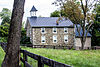 | February 23, 1984 (#84003546) | Snickersville Turnpike and Clayton Hall Rd. 39°06′40″N 77°50′04″W / 39.111111°N 77.834444°W / 39.111111; -77.834444 (Bluemont Historic District) | Bluemont | |
| 10 | Broad Run Bridge and Tollhouse |  | April 17, 1970 (#70000808) | Junction of State Routes 7 and State Route 28 with Broad Run 39°02′49″N 77°25′59″W / 39.046944°N 77.433194°W / 39.046944; -77.433194 (Broad Run Bridge and Tollhouse) | Sterling | |
| 11 | Brown-Koerner House |  | August 15, 2016 (#16000531) | 38340 Winsome Trail Ln. 39°10′23″N 77°40′28″W / 39.173056°N 77.674444°W / 39.173056; -77.674444 (Brown-Koerner House) | Purcellville | |
| 12 | Carlheim |  | December 28, 1979 (#79003050) | North of Leesburg on U.S. Route 15 39°07′22″N 77°33′16″W / 39.122778°N 77.554444°W / 39.122778; -77.554444 (Carlheim) | Leesburg | |
| 13 | Catoctin Creek Bridge |  | June 25, 1974 (#74002136) | Featherbed Ln., north of Waterford 39°13′56″N 77°35′29″W / 39.232222°N 77.591389°W / 39.232222; -77.591389 (Catoctin Creek Bridge) | Waterford | |
| 14 | Clapham's Ferry | 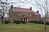 | September 4, 1997 (#97001076) | 44344 E. Spinks Ferry Rd. 39°13′21″N 77°27′52″W / 39.222500°N 77.464444°W / 39.222500; -77.464444 (Clapham's Ferry) | Leesburg | |
| 15 | Cleremont Farm |  | January 25, 1997 (#96001627) | Eastern side of Trappe Rd., 0.6 miles (0.97 km) northeast of Millville Rd. 39°02′53″N 77°51′49″W / 39.048056°N 77.863611°W / 39.048056; -77.863611 (Cleremont Farm) | Upperville | |
| 16 | Crednal |  | February 22, 2011 (#11000034) | 34500 Welbourne Rd. 39°00′22″N 77°48′41″W / 39.006111°N 77.811389°W / 39.006111; -77.811389 (Crednal) | Unison | |
| 17 | Douglass High School |  | September 24, 1992 (#92001274) | 408 E. Market St. 39°06′35″N 77°33′17″W / 39.109722°N 77.554722°W / 39.109722; -77.554722 (Douglass High School) | Leesburg | |
| 18 | Ebenezer Baptist Churches |  | June 3, 1994 (#94000548) | Northwestern corner of the junction of Airmont and Ebenezer Church Rds. 39°03′30″N 77°48′42″W / 39.058333°N 77.811667°W / 39.058333; -77.811667 (Ebenezer Baptist Churches) | Bloomfield | |
| 19 | Ellwood |  | February 11, 2004 (#04000054) | 17360 Count Turf Place 39°08′09″N 77°35′15″W / 39.135833°N 77.587500°W / 39.135833; -77.587500 (Ellwood) | Leesburg | |
| 20 | Fair Oaks |  | February 6, 2014 (#13001171) | 23718 New Mountain Rd. 38°57′45″N 77°38′00″W / 38.962500°N 77.633333°W / 38.962500; -77.633333 (Fair Oaks) | Aldie | |
| 21 | Farmer's Delight |  | June 2, 1973 (#73002033) | About 3 miles (4.8 km) north of Middleburg off Mountville Rd. 39°01′11″N 77°45′12″W / 39.019722°N 77.753333°W / 39.019722; -77.753333 (Farmer's Delight) | Leithtown | |
| 22 | Fleetwood Farm |  | February 1, 1991 (#90002172) | Evergreen Mills Rd. south of the junction with Red Hill Rd. 38°59′20″N 77°33′44″W / 38.988889°N 77.562222°W / 38.988889; -77.562222 (Fleetwood Farm) | Arcola | |
| 23 | Francis-Gulick Mill | Upload image | February 1, 2006 (#05001582) | Northern side of Goose Creek[6] 39°01′39″N 77°33′27″W / 39.027500°N 77.557500°W / 39.027500; -77.557500 (Francis-Gulick Mill) | Leesburg | |
| 24 | Furr Farm |  | August 17, 2012 (#12000541) | 40590 Snickersville Turnpike 38°59′30″N 77°39′45″W / 38.991667°N 77.662500°W / 38.991667; -77.662500 (Furr Farm) | Aldie | |
| 25 | Glebe of Shelburne Parish |  | April 1, 1975 (#75002023) | 3.5 miles (5.6 km) south of Lincoln off Shelburne Glebe Rd. 39°04′13″N 77°40′32″W / 39.070278°N 77.675556°W / 39.070278; -77.675556 (Glebe of Shelburne Parish) | Lincoln | |
| 26 | Amos Goodin House |  | June 12, 2017 (#100001081) | 37738 Wright Farm Dr. 39°09′01″N 77°41′54″W / 39.150278°N 77.698333°W / 39.150278; -77.698333 (Amos Goodin House) | Purcellville | |
| 27 | Goose Creek Historic District |  | November 14, 1982 (#82001822) | Roughly bounded by the town of Purcellville and Greggsville, Harmony Church, Mount Gilead, North Fork, Sands, and Telegraph Springs Rds. 39°06′51″N 77°41′50″W / 39.114167°N 77.697222°W / 39.114167; -77.697222 (Goose Creek Historic District) | Lincoln | |
| 28 | Goose Creek Meetinghouse Complex | July 24, 1974 (#74002135) | South of State Route 7 39°06′49″N 77°41′41″W / 39.113611°N 77.694722°W / 39.113611; -77.694722 (Goose Creek Meetinghouse Complex) | Lincoln | ||
| 29 | Goose Creek Stone Bridge |  | October 9, 1974 (#74002134) | Northwest of Atoka off U.S. Route 50 38°58′54″N 77°49′08″W / 38.981667°N 77.818889°W / 38.981667; -77.818889 (Goose Creek Stone Bridge) | Atoka | |
| 30 | Green Garden |  | July 24, 2007 (#07000769) | 22439 Green Garden Rd. 38°59′57″N 77°51′43″W / 38.999167°N 77.861944°W / 38.999167; -77.861944 (Green Garden) | Upperville | |
| 31 | Hamilton Masonic Lodge |  | December 9, 1999 (#99001505) | 43 S. Rogers St. 39°08′02″N 77°39′53″W / 39.133889°N 77.664861°W / 39.133889; -77.664861 (Hamilton Masonic Lodge) | Hamilton | |
| 32 | Harpers Ferry National Historical Park |  | October 15, 1966 (#66000041) | At the confluence of the Potomac and Shenandoah rivers 39°19′00″N 77°41′40″W / 39.316667°N 77.694444°W / 39.316667; -77.694444 (Harpers Ferry National Historical Park) | Harpers Ferry | |
| 33 | Hibbs Bridge |  | March 1, 2011 (#11000067) | Snickersville Turnpike, 6 miles (9.7 km) northwest of Aldie between Hibbs Bridge Rd. to the south and Watermill Rd. to the north 39°02′15″N 77°43′22″W / 39.0375°N 77.722778°W / 39.0375; -77.722778 (Hibbs Bridge) | Mountville | |
| 34 | Hillsboro Historic District |  | May 7, 1979 (#79003049) | State Route 9; also Charles Town Pike, between Hillsboro Rd. and Stony Point Rd. 39°11′56″N 77°43′28″W / 39.198889°N 77.724444°W / 39.198889; -77.724444 (Hillsboro Historic District) | Hillsboro | Charles Town Pike represents a boundary increase of March 23, 2012 |
| 35 | Home Farm |  | August 10, 2007 (#07000828) | 40332 Mount Gilead Rd. 39°04′36″N 77°36′32″W / 39.076667°N 77.608750°W / 39.076667; -77.608750 (Home Farm) | Leesburg | |
| 36 | Bernard Hough House | Upload image | August 9, 2021 (#100006815) | 15563 Hillsboro Rd. 39°11′11″N 77°43′12″W / 39.1864°N 77.7200°W / 39.1864; -77.7200 (Bernard Hough House) | Hillsboro vicinity | |
| 37 | Huntland |  | December 24, 2013 (#13000990) | 35955 Huntland Farm Rd. 39°00′44″N 77°45′45″W / 39.012222°N 77.762500°W / 39.012222; -77.762500 (Huntland) | Middleburg | |
| 38 | James Farm |  | March 18, 2019 (#100003543) | 15021 Mountain Rd. 39°12′11″N 77°42′56″W / 39.203056°N 77.715556°W / 39.203056; -77.715556 (James Farm) | Purcellville | |
| 39 | Janelia |  | March 20, 1987 (#86003596) | North side of State Route 7, 6 miles (9.7 km) east of Leesburg 39°04′10″N 77°27′57″W / 39.069583°N 77.465972°W / 39.069583; -77.465972 (Janelia) | Ashburn | |
| 40 | Janney House |  | November 27, 2004 (#04001269) | 15 W. Colonial Highway 39°08′05″N 77°39′55″W / 39.134861°N 77.665278°W / 39.134861; -77.665278 (Janney House) | Hamilton | |
| 41 | Ketoctin Baptist Church | 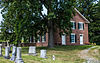 | May 22, 2003 (#03000452) | Approximately 2 miles (3.2 km) north of State Route 7 at the junction of Allder School Rd. and Ketoctin Church Rd. 39°09′27″N 77°44′56″W / 39.157500°N 77.748889°W / 39.157500; -77.748889 (Ketoctin Baptist Church) | Round Hill | |
| 42 | Leesburg Historic District |  | February 26, 1970 (#70000807) | Area of the original town centered at the junction of U.S. Route 15 and State Route 7; also roughly bounded by North and Union Sts., Morven Park Rd., and Harrison St. 39°06′54″N 77°33′54″W / 39.115000°N 77.565000°W / 39.115000; -77.565000 (Leesburg Historic District) | Leesburg | Second set of boundaries represents a boundary increase of May 22, 2001 |
| 43 | Little River Turnpike Bridge | 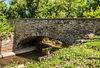 | April 11, 2014 (#14000148) | U.S. Route 50 over the Little River 38°58′31″N 77°38′22″W / 38.975278°N 77.639444°W / 38.975278; -77.639444 (Little River Turnpike Bridge) | Aldie | |
| 44 | Llangollen |  | August 21, 2017 (#100001497) | 21515 Trappe Rd. 39°01′51″N 77°53′31″W / 39.030889°N 77.891944°W / 39.030889; -77.891944 (Llangollen) | Upperville | |
| 45 | Locust Grove |  | February 21, 2007 (#07000083) | 200 Locust Grove Dr. 39°07′41″N 77°42′57″W / 39.128056°N 77.715833°W / 39.128056; -77.715833 (Locust Grove) | Purcellville | |
| 46 | Loudoun Agricultural and Mechanical Institute | 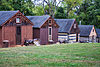 | July 8, 1982 (#82004568) | Oatlands Rd. 39°00′28″N 77°39′36″W / 39.007778°N 77.660000°W / 39.007778; -77.660000 (Loudoun Agricultural and Mechanical Institute) | Aldie | Now called Institute Farm |
| 47 | Lovettsville Historic District |  | August 10, 2012 (#12000518) | Roughly N. and S. Berlin Pike, E. Broad Way, S. Light, S. Locust, and S. Loudoun Sts., and Lovettsville Rd. 39°16′21″N 77°38′12″W / 39.272500°N 77.636667°W / 39.272500; -77.636667 (Lovettsville Historic District) | Lovettsville | |
| 48 | Lucketts School |  | October 14, 1993 (#93001125) | 42361 Lucketts Rd. 39°12′54″N 77°32′03″W / 39.215000°N 77.534167°W / 39.215000; -77.534167 (Lucketts School) | Lucketts | |
| 49 | Gen. George C. Marshall House |  | June 19, 1996 (#96000972) | 217 Edwards Ferry Rd. 39°06′49″N 77°33′35″W / 39.113611°N 77.559722°W / 39.113611; -77.559722 (Gen. George C. Marshall House) | Leesburg | |
| 50 | Middleburg Historic District |  | October 29, 1982 (#82001823) | U.S. Route 50 and The Plains and Landmark School Rds. 38°58′12″N 77°44′00″W / 38.970000°N 77.733333°W / 38.970000; -77.733333 (Middleburg Historic District) | Middleburg | |
| 51 | Gen. William Mitchell House |  | December 8, 1976 (#76002112) | 0.5 miles (0.80 km) south of Middleburg on The Plains Rd. 38°57′47″N 77°44′30″W / 38.963056°N 77.741667°W / 38.963056; -77.741667 (Gen. William Mitchell House) | Middleburg | The house and greater portion of the property are in Fauquier County |
| 52 | Morven Park |  | February 18, 1975 (#75002022) | 1 mile (1.6 km) northwest of Leesburg off U.S. Route 15 39°08′26″N 77°34′25″W / 39.140556°N 77.573611°W / 39.140556; -77.573611 (Morven Park) | Leesburg | |
| 53 | Mount Zion Old School Baptist Church-VDHR 53-339 |  | May 8, 1998 (#98000452) | 40309 U.S. Route 50 38°57′50″N 77°36′36″W / 38.963750°N 77.610000°W / 38.963750; -77.610000 (Mount Zion Old School Baptist Church-VDHR 53-339) | Aldie | |
| 54 | Mt. Olive Methodist Episcopal Church |  | January 20, 2005 (#04001542) | 20460 Gleedsville Rd. 39°03′03″N 77°36′10″W / 39.050833°N 77.602778°W / 39.050833; -77.602778 (Mt. Olive Methodist Episcopal Church) | Leesburg | |
| 55 | Much Haddam |  | December 28, 1990 (#90001988) | U.S. Route 50 west of its junction with The Plains Rd. 38°57′59″N 77°44′33″W / 38.966389°N 77.742500°W / 38.966389; -77.742500 (Much Haddam) | Middleburg | |
| 56 | Murray Hill |  | November 19, 2014 (#14000945) | 42910 Edwards Ferry Rd. 39°06′50″N 77°30′47″W / 39.113889°N 77.513056°W / 39.113889; -77.513056 (Murray Hill) | Leesburg | |
| 57 | Myrtle Hall Farm | 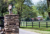 | May 17, 2006 (#06000408) | 19305 Ridgeside Rd. 39°05′01″N 77°50′07″W / 39.083611°N 77.835278°W / 39.083611; -77.835278 (Myrtle Hall Farm) | Bluemont | |
| 58 | Edward Nichols House | 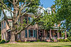 | December 4, 1987 (#87002117) | 330 W. Market St. 39°07′05″N 77°34′23″W / 39.118194°N 77.573056°W / 39.118194; -77.573056 (Edward Nichols House) | Leesburg | |
| 59 | Oak Hill |  | October 15, 1966 (#66000842) | 8 miles (13 km) south of Leesburg on U.S. Route 15 38°59′51″N 77°37′14″W / 38.997500°N 77.620556°W / 38.997500; -77.620556 (Oak Hill) | Leesburg | |
| 60 | Oakham Farm | 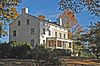 | February 2, 2016 (#15001039) | 23226 Oakham Farm Ln. 38°58′35″N 77°41′19″W / 38.976389°N 77.688611°W / 38.976389; -77.688611 (Oakham Farm) | Middleburg | |
| 61 | Oatlands |  | November 12, 1969 (#69000255) | South of the junction of U.S. Route 15 and Gap Rd. 39°02′27″N 77°37′03″W / 39.040833°N 77.617500°W / 39.040833; -77.617500 (Oatlands) | Leesburg | |
| 62 | Oatlands Historic District |  | May 3, 1974 (#74002327) | South of Leesburg off U.S. Route 15 39°01′48″N 77°37′20″W / 39.030138°N 77.622222°W / 39.030138; -77.622222 (Oatlands Historic District) | Leesburg | Expansion around Oatlands NHL incorporating scenic easements |
| 63 | Old Stone Church Archeological Site (44LD376) |  | September 7, 1989 (#89001402) | 110 Cornwall St., NW. 39°07′02″N 77°33′56″W / 39.117109°N 77.565635°W / 39.117109; -77.565635 (Old Stone Church Archeological Site (44LD376)) | Leesburg | |
| 64 | Old Welbourne Farm and Dulany Family Cemetery |  | February 6, 2014 (#13001172) | 21398 Willisville Rd. 39°01′44″N 77°49′21″W / 39.028861°N 77.822500°W / 39.028861; -77.822500 (Old Welbourne Farm and Dulany Family Cemetery) | Bluemont | |
| 65 | Paeonian Springs Historic District |  | May 1, 2006 (#06000352) | Parts of Berry Bramble Ln., Catoctin Ridge St., Charles Town Pike, Highland Circle, and Simpson Circle 39°08′58″N 77°37′12″W / 39.149444°N 77.620000°W / 39.149444; -77.620000 (Paeonian Springs Historic District) | Paeonian Springs | |
| 66 | Philomont Historic District | Upload image | December 5, 2023 (#100009206) | Jct. of VA 630 (JEB Stuart Rd.) and VA 734 (Snickersville Tpk.) 39°03′23″N 77°44′25″W / 39.0564°N 77.7404°W / 39.0564; -77.7404 (Philomont Historic District) | Philomont | |
| 67 | Purcellville Historic District |  | April 4, 2007 (#07000277) | Roughly bounded by the Washington & Old Dominion Trail, S. 32nd St., W. F and E. G Sts., and Maple Ave. 39°08′13″N 77°42′54″W / 39.136944°N 77.715000°W / 39.136944; -77.715000 (Purcellville Historic District) | Purcellville | |
| 68 | Purcellville Train Station |  | May 28, 2010 (#10000307) | 200 N. 21st St. 39°08′18″N 77°42′58″W / 39.138472°N 77.716111°W / 39.138472; -77.716111 (Purcellville Train Station) | Purcellville | |
| 69 | Red Fox Inn |  | November 13, 1997 (#97001403) | 2 E. Washington St. 38°58′09″N 77°44′08″W / 38.969167°N 77.735417°W / 38.969167; -77.735417 (Red Fox Inn) | Middleburg | |
| 70 | Rich Bottom Farm |  | February 21, 1997 (#97000156) | 16860 Hillsboro Rd., 1.5 miles (2.4 km) north of Purcellville 39°08′59″N 77°44′01″W / 39.149722°N 77.733611°W / 39.149722; -77.733611 (Rich Bottom Farm) | Purcellville | |
| 71 | Rock Hill Farm |  | August 27, 2009 (#09000664) | 20775 Airmont Rd. 39°02′55″N 77°49′52″W / 39.048611°N 77.831111°W / 39.048611; -77.831111 (Rock Hill Farm) | Bluemont | |
| 72 | Rock Spring Farm |  | March 13, 2002 (#02000177) | 329 Loudoun St., SW. 39°06′58″N 77°34′26″W / 39.116111°N 77.573889°W / 39.116111; -77.573889 (Rock Spring Farm) | Leesburg | |
| 73 | Rockland |  | May 14, 1987 (#87000752) | Eastern side of U.S. Route 15, north of Leesburg 39°09′50″N 77°32′05″W / 39.163889°N 77.534722°W / 39.163889; -77.534722 (Rockland) | Leesburg | |
| 74 | Rokeby |  | May 30, 1976 (#76002109) | 2.4 miles (3.9 km) southwest of Leesburg off Gleedsville Rd. 39°04′18″N 77°35′46″W / 39.071667°N 77.596111°W / 39.071667; -77.596111 (Rokeby) | Leesburg | |
| 75 | Rose Hill Farm |  | August 25, 1994 (#94000986) | Northern side of U.S. Route 50, 1.5 miles (2.4 km) west of the junction with Atoka Rd. 38°59′00″N 77°49′41″W / 38.983333°N 77.828056°W / 38.983333; -77.828056 (Rose Hill Farm) | Upperville | |
| 76 | Round Hill Historic District |  | May 28, 2009 (#09000366) | Roughly bounded by State Route 7 to the south, Locust St. to the west, Bridge St. on the east, and the northern edge of Main St. to the north 39°07′58″N 77°46′06″W / 39.132778°N 77.768333°W / 39.132778; -77.768333 (Round Hill Historic District) | Round Hill | |
| 77 | Shiloh Baptist Church |  | November 24, 2017 (#100001852) | 304 E. Marshall St. 38°58′18″N 77°43′54″W / 38.971667°N 77.731667°W / 38.971667; -77.731667 (Shiloh Baptist Church) | Middleburg | |
| 78 | Sleepy Hollow Farm |  | February 13, 2007 (#07000048) | 39902 Thomas Mill Rd. 39°06′57″N 77°37′27″W / 39.115972°N 77.624028°W / 39.115972; -77.624028 (Sleepy Hollow Farm) | Leesburg | |
| 79 | William Smith House |  | April 2, 2003 (#03000189) | 38678 Piggott Bottom Rd. 39°09′35″N 77°39′57″W / 39.159722°N 77.665833°W / 39.159722; -77.665833 (William Smith House) | Hamilton | |
| 80 | Snickersville Turnpike | Upload image | June 16, 2022 (#100007792) | Snickersville Turnpike, VA 734 39°02′32″N 77°43′38″W / 39.04225°N 77.7273°W / 39.04225; -77.7273 (Snickersville Turnpike) | Bluemont vicinity | |
| 81 | Spring Hill Farm | 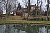 | July 27, 2005 (#05000766) | 39018 Piggott Bottom Rd. 39°09′15″N 77°38′56″W / 39.154167°N 77.648889°W / 39.154167; -77.648889 (Spring Hill Farm) | Hamilton | |
| 82 | Stoke |  | December 8, 2015 (#15000878) | 23587 Stoke Farm Ln. 38°58′01″N 77°39′56″W / 38.966944°N 77.665556°W / 38.966944; -77.665556 (Stoke) | Aldie | |
| 83 | Sunnyside Farm |  | August 16, 1994 (#94000989) | South side of State Route 7 Business, 1,150 feet (350 m) east of the junction with State Route 287 39°07′54″N 77°41′18″W / 39.131528°N 77.688472°W / 39.131528; -77.688472 (Sunnyside Farm) | Hamilton | |
| 84 | The Tabernacle-Fireman's Field |  | May 28, 2010 (#10000308) | 250 S. Nursery Ave. 39°08′00″N 77°42′54″W / 39.133333°N 77.715000°W / 39.133333; -77.715000 (The Tabernacle-Fireman's Field) | Purcellville | |
| 85 | Taylorstown Historic District | 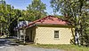 | January 30, 1978 (#78003027) | Around the junction of Taylorstown and Downey Mill Rds. at Catoctin Creek; also 13122 Furnace Mountain, 12969 and 13090 Taylorstown, and 12995 and 13000 Hoysville Rds. 39°15′15″N 77°34′31″W / 39.254167°N 77.575278°W / 39.254167; -77.575278 (Taylorstown Historic District) | Taylorstown | District includes Whiskey Hill. Second set of boundaries represents a boundary increase of May 26, 2005 |
| 86 | Temple Hall |  | February 13, 2007 (#07000053) | 15764 Temple Hall Ln. 39°10′41″N 77°31′43″W / 39.177917°N 77.528611°W / 39.177917; -77.528611 (Temple Hall) | Leesburg | |
| 87 | Union Street School | Upload image | February 14, 2023 (#100008649) | 20 Union St. 39°07′12″N 77°33′50″W / 39.1199°N 77.5638°W / 39.1199; -77.5638 (Union Street School) | Leesburg | |
| 88 | Unison Battlefield Historic District |  | November 22, 2011 (#11000835) | Parts of Quaker Ln. and Jeb Stuart, Unison, Newlin Mill, Millville, Bloomfield, Welbourne, and Greengarden Rds. 39°02′12″N 77°47′15″W / 39.036667°N 77.787500°W / 39.036667; -77.787500 (Unison Battlefield Historic District) | Unison | |
| 89 | Unison Historic District | 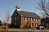 | May 22, 2003 (#03000442) | Parts of Unison and Bloomfield Rds. 39°02′07″N 77°47′28″W / 39.035278°N 77.791111°W / 39.035278; -77.791111 (Unison Historic District) | Middleburg | |
| 90 | Dr. Joseph Vandeventer House | Upload image | March 23, 2022 (#100007538) | 39901 Highfield Park Ln. 39°07′57″N 77°37′15″W / 39.1326°N 77.6209°W / 39.1326; -77.6209 (Dr. Joseph Vandeventer House) | Leesburg vicinity | |
| 91 | Vestal's Gap Road and Lanesville Historic District |  | February 3, 2000 (#99001722) | 21544 Cascades Parkway 39°01′03″N 77°24′13″W / 39.017500°N 77.403611°W / 39.017500; -77.403611 (Vestal's Gap Road and Lanesville Historic District) | Sterling | |
| 92 | William Virts House |  | February 22, 2011 (#11000027) | 38670 Old Wheatland Rd. 39°11′16″N 77°39′57″W / 39.187639°N 77.665972°W / 39.187639; -77.665972 (William Virts House) | Waterford | |
| 93 | Waterford Historic District |  | June 3, 1969 (#69000256) | Northwest of Leesburg on Loyalty Rd. 39°11′12″N 77°36′44″W / 39.186667°N 77.612222°W / 39.186667; -77.612222 (Waterford Historic District) | Waterford | |
| 94 | Waverly |  | February 10, 1983 (#83003288) | 212 S. King St. 39°06′22″N 77°34′05″W / 39.106111°N 77.567917°W / 39.106111; -77.567917 (Waverly) | Leesburg | |
| 95 | Welbourne | 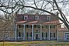 | February 23, 1972 (#72001404) | Northwest of the junction of Welbourne and St. Louis Rds. 39°00′04″N 77°48′44″W / 39.001111°N 77.812222°W / 39.001111; -77.812222 (Welbourne) | Middleburg | |
| 96 | Willisville Historic District |  | December 9, 2019 (#100004746) | 33000 & 34000 blks. of Welbourne Rd. 39°00′27″N 77°50′03″W / 39.0074°N 77.8343°W / 39.0074; -77.8343 (Willisville Historic District) | Middleburg vicinity | |
| 97 | Woodburn |  | December 12, 1976 (#76002111) | 3 miles (4.8 km) southwest of Leesburg off Harmony Church Rd. 39°05′22″N 77°37′10″W / 39.0894°N 77.6194°W / 39.0894; -77.6194 (Woodburn) | Leesburg | |
| 98 | Woodgrove |  | September 14, 2002 (#02001004) | 16860 Woodgrove Rd. 39°09′06″N 77°46′10″W / 39.1518°N 77.7694°W / 39.1518; -77.7694 (Woodgrove) | Round Hill |
Former listing
| [3] | Name on the Register | Image | Date listed | Date removed | Location | City or town | Description |
|---|---|---|---|---|---|---|---|
| 1 | Exeter | Upload image | August 14, 1973 (#73002032) | March 19, 2001 | East of Leesburg on Edwards Ferry Rd. 39°06′57″N 77°32′26″W / 39.115833°N 77.540556°W / 39.115833; -77.540556 (Exeter) | Leesburg | Burned August 1980 |
See also
Wikimedia Commons has media related to National Register of Historic Places in Loudoun County, Virginia.
- List of National Historic Landmarks in Virginia
- National Register of Historic Places listings in Virginia
References
- ^ The latitude and longitude information provided in this table was derived originally from the National Register Information System, which has been found to be fairly accurate for about 99% of listings. Some locations in this table may have been corrected to current GPS standards.
- ^ National Park Service, United States Department of the Interior, "National Register of Historic Places: Weekly List Actions", retrieved June 14, 2024.
- ^ a b Numbers represent an alphabetical ordering by significant words. Various colorings, defined here, differentiate National Historic Landmarks and historic districts from other NRHP buildings, structures, sites or objects.
- ^ "National Register Information System". National Register of Historic Places. National Park Service. April 24, 2008.
- ^ The eight-digit number below each date is the number assigned to each location in the National Register Information System database, which can be viewed by clicking the number.
- ^ Mullen, John P. National Register of Historic Places Inventory/Nomination: Francis/Gulick Mill. National Park Service, 2005-06-30, 19.
- v
- t
- e
by county
- Accomack
- Albemarle
- Alleghany
- Amelia
- Amherst
- Appomattox
- Arlington
- Augusta
- Bath
- Bedford
- Bland
- Botetourt
- Brunswick
- Buchanan
- Buckingham
- Campbell
- Caroline
- Carroll
- Charles City
- Charlotte
- Chesterfield
- Clarke
- Craig
- Culpeper
- Cumberland
- Dickenson
- Dinwiddie
- Essex
- Fairfax
- Fauquier
- Floyd
- Fluvanna
- Franklin
- Frederick
- Giles
- Gloucester
- Goochland
- Grayson
- Greene
- Greensville
- Halifax
- Hanover
- Henrico
- Henry
- Highland
- Isle Of Wight
- James City
- King and Queen
- King George
- King William
- Lancaster
- Lee
- Loudoun
- Louisa
- Lunenburg
- Madison
- Mathews
- Mecklenburg
- Middlesex
- Montgomery
- Nelson
- New Kent
- Northampton
- Northumberland
- Nottoway
- Orange
- Page
- Patrick
- Pittsylvania
- Powhatan
- Prince Edward
- Prince George
- Prince William
- Pulaski
- Rappahannock
- Richmond
- Roanoke
- Rockbridge
- Rockingham
- Russell
- Scott
- Shenandoah
- Smyth
- Southampton
- Spotsylvania
- Stafford
- Surry
- Sussex
- Tazewell
- Warren
- Washington
- Westmoreland
- Wise
- Wythe
- York

by city
- Alexandria
- Bristol
- Buena Vista
- Charlottesville
- Chesapeake
- Colonial Heights
- Covington
- Danville
- Emporia
- Fairfax
- Falls Church
- Franklin
- Fredericksburg
- Galax
- Hampton
- Harrisonburg
- Hopewell
- Lexington
- Lynchburg
- Manassas
- Manassas Park
- Martinsville
- Newport News
- Norfolk
- Norton
- Petersburg
- Poquoson (no listings)
- Portsmouth
- Radford
- Richmond
- Roanoke
- Salem
- Staunton
- Suffolk
- Virginia Beach
- Waynesboro
- Williamsburg
- Winchester
Municipalities and communities of Loudoun County, Virginia, United States | ||
|---|---|---|
County seat: Leesburg | ||
| Towns |  | |
| CDPs | ||
| Unincorporated communities |
| |
| Former | ||
| ||


