National Register of Historic Places listings in Gadsden County, Florida
This is a list of the National Register of Historic Places listings in Gadsden County, Florida.
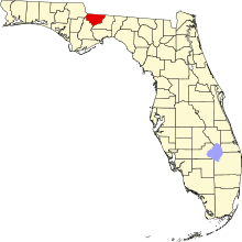
This is intended to be a complete list of the properties and districts on the National Register of Historic Places in Gadsden County, Florida, United States. The locations of National Register properties and districts for which the latitude and longitude coordinates are included below, may be seen in a map.[1]
There are 18 properties and districts listed on the National Register in the county.
This National Park Service list is complete through NPS recent listings posted May 31, 2024.[2]
Map all coordinates using OpenStreetMap
Download coordinates as:
- KML
- GPX (all coordinates)
- GPX (primary coordinates)
- GPX (secondary coordinates)
| Alachua - Baker - Bay - Bradford - Brevard - Broward - Calhoun - Charlotte - Citrus - Clay - Collier - Columbia - DeSoto - Dixie - Duval - Escambia - Flagler - Franklin - Gadsden - Gilchrist - Glades - Gulf - Hamilton - Hardee - Hendry - Hernando - Highlands - Hillsborough (Tampa) - Holmes - Indian River - Jackson - Jefferson - Lafayette - Lake - Lee - Leon - Levy - Liberty - Madison - Manatee - Marion - Martin - Miami-Dade (Miami) - Monroe - Nassau - Okaloosa - Okeechobee - Orange - Osceola - Palm Beach - Pasco - Pinellas - Polk - Putnam - St. Johns - St. Lucie - Santa Rosa - Sarasota - Seminole - Sumter - Suwannee - Taylor - Union - Volusia - Wakulla - Walton - Washington |
Current listings
| [3] | Name on the Register[4] | Image | Date listed[5] | Location | City or town | Description |
|---|---|---|---|---|---|---|
| 1 | Chattahoochee Historic District | Upload image | September 4, 2020 (#100005240) | North Bolivar and Decatur Sts., East Washington St., South McDonald Ave., and East Chattahoochee St. 30°42′19″N 84°50′51″W / 30.7052°N 84.8475°W / 30.7052; -84.8475 (Chattahoochee Historic District) | Chattahoochee | |
| 2 | Joshua Davis House |  | May 21, 1975 (#75000554) | 2½ miles northwest of Mt. Pleasant on U.S. Route 90 30°41′19″N 84°43′20″W / 30.6886°N 84.7222°W / 30.6886; -84.7222 (Joshua Davis House) | Mount Pleasant | |
| 3 | Dezell House |  | May 10, 2006 (#06000358) | 328 East 8th Street 30°34′00″N 84°44′38″W / 30.5666°N 84.7439°W / 30.5666; -84.7439 (Dezell House) | Greensboro | |
| 4 | Willoughby Gregory House |  | December 16, 1983 (#83003520) | Highway 274 and Krausland Road 30°33′29″N 84°36′43″W / 30.5581°N 84.6119°W / 30.5581; -84.6119 (Willoughby Gregory House) | Quincy | |
| 5 | Gretna School |  | June 10, 2008 (#08000502) | 722 Church Street 30°37′01″N 84°39′10″W / 30.6169°N 84.6527°W / 30.6169; -84.6527 (Gretna School) | Gretna | |
| 6 | E. C. Love House | 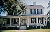 | December 30, 1974 (#74000626) | 219 North Jackson Street 30°35′26″N 84°34′45″W / 30.5906°N 84.5792°W / 30.5906; -84.5792 (E. C. Love House) | Quincy | |
| 7 | John Lee McFarlin House |  | December 27, 1974 (#74000627) | 305 East King Street 30°35′26″N 84°34′22″W / 30.5906°N 84.5728°W / 30.5906; -84.5728 (John Lee McFarlin House) | Quincy | |
| 8 | Dr. Malcolm Nicholson Farmhouse |  | October 28, 1994 (#94001272) | Northern side of State Road 12, west of Havana 30°36′39″N 84°28′14″W / 30.6108°N 84.4706°W / 30.6108; -84.4706 (Dr. Malcolm Nicholson Farmhouse) | Havana | |
| 9 | Northside High School |  | February 4, 2019 (#100003408) | 264 Carver Ave. 30°38′17″N 84°24′46″W / 30.6381°N 84.4129°W / 30.6381; -84.4129 (Northside High School) | Havana | |
| 10 | Old Philadelphia Presbyterian Church |  | February 24, 1975 (#75000557) | 5 miles north of Quincy off State Road 65 30°38′37″N 84°34′38″W / 30.6436°N 84.5772°W / 30.6436; -84.5772 (Old Philadelphia Presbyterian Church) | Quincy | |
| 11 | Planter's Exchange, Inc. |  | September 17, 1999 (#99001147) | 204 Second Street, Northwest 30°37′28″N 84°25′02″W / 30.6244°N 84.4172°W / 30.6244; -84.4172 (Planter's Exchange, Inc.) | Havana | |
| 12 | Quincy Historic District |  | November 9, 1978 (#78000942) | Roughly bounded by Sharon, Clark, Stewart, and Corry Streets 30°35′28″N 84°34′30″W / 30.5911°N 84.575°W / 30.5911; -84.575 (Quincy Historic District) | Quincy | |
| 13 | Quincy Library |  | September 9, 1974 (#74000628) | 303 North Adams Street 30°35′28″N 84°34′37″W / 30.5911°N 84.5769°W / 30.5911; -84.5769 (Quincy Library) | Quincy | |
| 14 | Quincy Woman's Club | 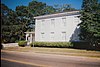 | March 10, 1975 (#75000555) | 300 North Calhoun Street 30°35′27″N 84°34′51″W / 30.5908°N 84.5808°W / 30.5908; -84.5808 (Quincy Woman's Club) | Quincy | |
| 15 | E. B. Shelfer House |  | April 4, 1975 (#75000556) | 205 North Madison Street 30°35′25″N 84°34′31″W / 30.5903°N 84.5753°W / 30.5903; -84.5753 (E. B. Shelfer House) | Quincy | |
| 16 | Stockton-Curry House |  | December 31, 1974 (#74000629) | 121 North Duval Street 30°35′23″N 84°34′28″W / 30.5897°N 84.5744°W / 30.5897; -84.5744 (Stockton-Curry House) | Quincy | |
| 17 | U.S. Arsenal-Officers Quarters |  | July 2, 1973 (#73000578) | Florida State Hospital, U.S. Route 90 30°42′24″N 84°50′12″W / 30.7067°N 84.8367°W / 30.7067; -84.8367 (U.S. Arsenal-Officers Quarters) | Chattahoochee | |
| 18 | Judge P. W. White House | 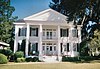 | December 5, 1972 (#72000319) | 212 North Madison Street 30°35′27″N 84°34′34″W / 30.5908°N 84.5761°W / 30.5908; -84.5761 (Judge P. W. White House) | Quincy |
Former listings
| [3] | Name on the Register | Image | Date listed | Date removed | Location | City or town | Description |
|---|---|---|---|---|---|---|---|
| 1 | Malachi Martin House | Upload image | August 11, 1976 (#76000597) | June 2, 1989 | 5 mi. E of Chattahoochee off U.S. 90 | Chattahoochee vicinity | Burned down in 1986[6] |
See also
Wikimedia Commons has media related to National Register of Historic Places in Gadsden County, Florida.
- List of National Historic Landmarks in Florida
- National Register of Historic Places listings in Florida
References
- ^ The latitude and longitude information provided in this table was derived originally from the National Register Information System, which has been found to be fairly accurate for about 99% of listings. Some locations in this table may have been corrected to current GPS standards.
- ^ National Park Service, United States Department of the Interior, "National Register of Historic Places: Weekly List Actions", retrieved May 31, 2024.
- ^ a b Numbers represent an alphabetical ordering by significant words. Various colorings, defined here, differentiate National Historic Landmarks and historic districts from other NRHP buildings, structures, sites or objects.
- ^ "National Register Information System". National Register of Historic Places. National Park Service. March 13, 2009.
- ^ The eight-digit number below each date is the number assigned to each location in the National Register Information System database, which can be viewed by clicking the number.
- ^ "Florida Martin, Malachi, House: Withdrawn". National Register of Historic Places and National Historic Landmarks Program Records: Florida, 1/1/1964 - 12/31/2013. Retrieved 22 December 2019.
- v
- t
- e
by county
- Alachua
- Baker
- Bay
- Bradford
- Brevard
- Broward
- Calhoun
- Charlotte
- Citrus
- Clay
- Collier
- Columbia
- DeSoto
- Dixie
- Duval
- Escambia
- Flagler
- Franklin
- Gadsden
- Gilchrist
- Glades
- Gulf
- Hamilton
- Hardee
- Hendry
- Hernando
- Highlands
- Hillsborough
- Holmes
- Indian River
- Jackson
- Jefferson
- Lake
- Lee
- Leon
- Levy
- Liberty
- Madison
- Manatee
- Marion
- Martin
- Miami-Dade
- Monroe
- Nassau
- Okaloosa
- Okeechobee
- Orange
- Osceola
- Palm Beach
- Pasco
- Pinellas
- Polk
- Putnam
- Santa Rosa
- Sarasota
- Seminole
- St. Johns
- St. Lucie
- Sumter
- Suwannee
- Taylor
- Union
- Volusia
- Wakulla
- Walton
- Washington


