National Register of Historic Places listings in Coshocton County, Ohio

This is a list of the National Register of Historic Places listings in Coshocton County, Ohio.
This is intended to be a complete list of the properties and districts on the National Register of Historic Places in Coshocton County, Ohio, United States. The locations of National Register properties and districts for which the latitude and longitude coordinates are included below, may be seen in an online map.[1]
There are 20 properties and districts listed on the National Register in the county. Another property was once listed but has been removed.
This National Park Service list is complete through NPS recent listings posted June 14, 2024.[2]
Map all coordinates using OpenStreetMap
Download coordinates as:
- KML
- GPX (all coordinates)
- GPX (primary coordinates)
- GPX (secondary coordinates)
Current listings
| [3] | Name on the Register[4] | Image | Date listed[5] | Location | City or town | Description |
|---|---|---|---|---|---|---|
| 1 | Adams-Gray House |  | December 5, 1979 (#79001797) | Southeast of Trinway on Tobacco Hill Rd. 40°09′31″N 81°56′54″W / 40.158611°N 81.948333°W / 40.158611; -81.948333 (Adams-Gray House) | Virginia Township | Extends into Cass Township in Muskingum County |
| 2 | Chalfant Church |  | March 15, 1982 (#82004416) | South of Warsaw off State Route 60 40°10′58″N 82°01′06″W / 40.182778°N 82.018333°W / 40.182778; -82.018333 (Chalfant Church) | Washington Township | |
| 3 | Coshocton County Courthouse | 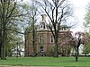 | May 22, 1973 (#73001402) | Courthouse Sq. 40°16′27″N 81°51′59″W / 40.274167°N 81.866389°W / 40.274167; -81.866389 (Coshocton County Courthouse) | Coshocton | |
| 4 | Coshocton Main Street Historic District | 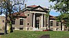 | February 28, 2019 (#100003497) | Roughly bounded by Main, Chestnut, and Walnut Sts. between 3rd and 7th Sts. 40°16′25″N 81°51′50″W / 40.273611°N 81.863889°W / 40.273611; -81.863889 (Coshocton Main Street Historic District) | Coshocton | |
| 5 | Eldridge-Higgins Building |  | August 6, 1998 (#98001012) | 525 Orange St. 40°16′14″N 81°51′48″W / 40.270694°N 81.863333°W / 40.270694; -81.863333 (Eldridge-Higgins Building) | Coshocton | |
| 6 | Andrew Ferguson House |  | November 30, 1978 (#78002028) | East of West Lafayette on State Route 751 40°16′19″N 81°43′38″W / 40.271944°N 81.727222°W / 40.271944; -81.727222 (Andrew Ferguson House) | Lafayette Township | |
| 7 | Helmick Covered Bridge |  | June 18, 1975 (#75001348) | East of Blissfield on Township Road 25 40°23′35″N 81°56′34″W / 40.393056°N 81.942778°W / 40.393056; -81.942778 (Helmick Covered Bridge) | Clark Township | |
| 8 | Thomas Johnson House |  | May 14, 1982 (#82004415) | State Route 541 40°12′33″N 81°43′01″W / 40.209167°N 81.717083°W / 40.209167; -81.717083 (Thomas Johnson House) | Plainfield | |
| 9 | Johnson-Humrickhouse House | 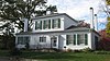 | October 9, 1974 (#74001424) | 302 S. 3rd St. 40°16′14″N 81°52′00″W / 40.270556°N 81.866667°W / 40.270556; -81.866667 (Johnson-Humrickhouse House) | Coshocton | |
| 10 | Lamberson-Markley Houses |  | October 18, 1984 (#84000125) | 713 Main St. in Canal Lewisville 40°17′55″N 81°50′24″W / 40.298750°N 81.840000°W / 40.298750; -81.840000 (Lamberson-Markley Houses) | Tuscarawas Township | |
| 11 | Samuel Lee House |  | December 6, 1979 (#79001796) | 306 4th St. 40°16′36″N 81°51′54″W / 40.276667°N 81.865°W / 40.276667; -81.865 (Samuel Lee House) | Coshocton | |
| 12 | J.F. Meek Buildings |  | January 2, 1985 (#85000033) | 546 Chestnut St. and 213-215 N. 6th St. 40°16′30″N 81°51′43″W / 40.275°N 81.861944°W / 40.275; -81.861944 (J.F. Meek Buildings) | Coshocton | |
| 13 | Daniel Miller House |  | January 3, 1980 (#80002967) | West of West Lafayette at 52357 County Road 16 40°16′40″N 81°46′41″W / 40.277778°N 81.778056°W / 40.277778; -81.778056 (Daniel Miller House) | Lafayette Township | |
| 14 | Cuthbert Milligan House |  | November 25, 1980 (#80002966) | North of Coshocton 40°19′58″N 81°53′36″W / 40.332778°N 81.893333°W / 40.332778; -81.893333 (Cuthbert Milligan House) | Keene Township | |
| 15 | Muskingum River Navigation Historic District | 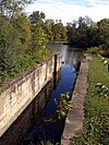 | February 9, 2007 (#07000025) | Coshocton, Muskingum, Morgan, Washington Counties 40°17′02″N 81°52′39″W / 40.283889°N 81.877500°W / 40.283889; -81.877500 (Muskingum River Navigation Historic District) | Numerous jurisdictions | |
| 16 | Eli Nichols Farm | 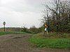 | November 29, 1982 (#82001364) | Off the junction of Rabbit Ridge and Brush Run Rds., west of Walhonding[6] 40°21′16″N 82°10′59″W / 40.354444°N 82.183056°W / 40.354444; -82.183056 (Eli Nichols Farm) | Newcastle Township | |
| 17 | Old Union School |  | October 18, 1984 (#84000127) | 310 Sycamore St. 40°16′41″N 81°51′59″W / 40.278056°N 81.866389°W / 40.278056; -81.866389 (Old Union School) | Coshocton | |
| 18 | Roscoe Village | 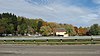 | April 3, 1973 (#73001403) | Whitewoman and High Sts. 40°16′35″N 81°52′36″W / 40.276389°N 81.876667°W / 40.276389; -81.876667 (Roscoe Village) | Coshocton | |
| 19 | Walhonding Canal Lock No. 9 |  | February 24, 1986 (#86000307) | State Route 715, west of Warsaw 40°20′42″N 82°04′33″W / 40.345°N 82.075833°W / 40.345; -82.075833 (Walhonding Canal Lock No. 9) | Jefferson Township | |
| 20 | Warsaw Hotel | 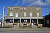 | March 17, 1994 (#94000244) | 102 E. Main St. 40°20′08″N 82°00′23″W / 40.335556°N 82.006389°W / 40.335556; -82.006389 (Warsaw Hotel) | Warsaw |
Former listing
| [3] | Name on the Register | Image | Date listed | Date removed | Location | City or town | Description |
|---|---|---|---|---|---|---|---|
| 1 | Rodrick Bridge |  | November 29, 1978 (#78002027) | April 10, 1998 | 8.5 miles (13.6 km) southeast of Coshocton 40°10′00″N 81°46′20″W / 40.166667°N 81.772222°W / 40.166667; -81.772222 (Rodrick Bridge) | Coshocton | Moved to the OSU-Newark campus in 1997.[7] Relisted in Licking County in 1998. |
See also
Wikimedia Commons has media related to National Register of Historic Places in Coshocton County, Ohio.
- List of National Historic Landmarks in Ohio
- Listings in neighboring counties: Guernsey, Holmes, Knox, Licking, Muskingum, Tuscarawas
- National Register of Historic Places listings in Ohio
References
- ^ The latitude and longitude information provided in this table was derived originally from the National Register Information System, which has been found to be fairly accurate for about 99% of listings. Some locations in this table may have been corrected to current GPS standards.
- ^ National Park Service, United States Department of the Interior, "National Register of Historic Places: Weekly List Actions", retrieved June 14, 2024.
- ^ a b Numbers represent an alphabetical ordering by significant words. Various colorings, defined here, differentiate National Historic Landmarks and historic districts from other NRHP buildings, structures, sites or objects.
- ^ "National Register Information System". National Register of Historic Places. National Park Service. April 24, 2008.
- ^ The eight-digit number below each date is the number assigned to each location in the National Register Information System database, which can be viewed by clicking the number.
- ^ Location derived from 2009 Heart of Ohio Tour[permanent dead link], Knox County Convention and Visitors Bureau, 2009. Accessed 2010-03-26. The NRIS lists the site as "Address Restricted".
- ^ "Bridge linking county to national fame". The Newark Advocate. March 30, 1998. p. 1. Retrieved August 14, 2022 – via Newspapers.com.
- v
- t
- e
by county
- Adams
- Allen
- Ashland
- Ashtabula
- Athens
- Auglaize
- Belmont
- Brown
- Butler
- Carroll
- Champaign
- Clark
- Clermont
- Clinton
- Columbiana
- Coshocton
- Crawford
- Cuyahoga
- Darke
- Defiance
- Delaware
- Erie
- Fairfield
- Fayette
- Franklin
- Fulton
- Gallia
- Geauga
- Greene
- Guernsey
- Hamilton
- Hancock
- Hardin
- Harrison
- Henry
- Highland
- Hocking
- Holmes
- Huron
- Jackson
- Jefferson
- Knox
- Lake
- Lawrence
- Licking
- Logan
- Lorain
- Lucas
- Madison
- Mahoning
- Marion
- Medina
- Meigs
- Mercer
- Miami
- Monroe
- Montgomery
- Morgan
- Morrow
- Muskingum
- Noble
- Ottawa
- Paulding
- Perry
- Pickaway
- Pike
- Portage
- Preble
- Putnam
- Richland
- Ross
- Sandusky
- Scioto
- Seneca
- Shelby
- Stark
- Summit
- Trumbull
- Tuscarawas
- Union
- Van Wert
- Vinton
- Warren
- Washington
- Wayne
- Williams
- Wood
- Wyandot

Municipalities and communities of Coshocton County, Ohio, United States | ||
|---|---|---|
County seat: Coshocton | ||
| City |  | |
| Villages | ||
| Townships | ||
| CDPs | ||
| Unincorporated communities |
| |
| Ghost towns | ||
| Footnotes | ‡This populated place also has portions in an adjacent county or counties | |
| ||


