Nakakoma District, Yamanashi
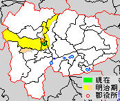
* yellow - areas formerly within the district borders during the early Meiji period
* green - current borders
- Shōwa-machi

Nakakoma (中巨摩郡, Nakakoma-gun) is a district located in Yamanashi Prefecture, Japan.
As of 1 October 2020, the district has a population of 20,909 with a density of 2,3 persons per km2. The total area is 9.08 km2.[1]
Municipalities
The district consists of one town:
- Notes
- ^ Classified as a town.
History
This list is incomplete; you can help by adding missing items. (March 2023) |
District Timeline
Nakakoma District was founded from the split of Koma District during the early Meiji period establishment of the municipalities system on July 22, 1878 and initially consisted of 52 villages.
Recent mergers
- On April 1, 2003 - The towns of Shirane, Wakakusa, Kushigata and Kōsai, and the villages of Hatta and Ashiyasu were merged to form the new city of Minami-Alps.
- On September 1, 2004 - The towns of Ryūō and Shikishima were merged with the town of Futaba (from Kitakoma District) to form the new city of Kai.
- On February 20, 2006 - The towns of Tamaho and Tatomi were merged with the village of Toyotomi (from Higashiyatsushiro District) to form the new city of Chūō.
References
- ^ "Nakakoma (District (-gun), Yamanashi, Japan) - Population Statistics, Charts, Map and Location". www.citypopulation.de. Retrieved 2023-10-13.


Authority control databases | |
|---|---|
| International |
|
| National |
|
35°37′30″N 138°32′06″E / 35.6251°N 138.5350°E / 35.6251; 138.5350
 | This article about a location in Yamanashi Prefecture is a stub. You can help Wikipedia by expanding it. |
- v
- t
- e


