Monterrein
Part of Ploërmel in Brittany, France
Monterrein Mousterrin | |
|---|---|
Part of Ploërmel | |
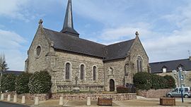 The church of Saint-Malo, in Monterrein | |
 Coat of arms | |
Location of Monterrein  | |
47°52′52″N 2°21′24″W / 47.8811°N 2.3566°W / 47.8811; -2.3566 | |
| Country | France |
| Region | Brittany |
| Department | Morbihan |
| Arrondissement | Pontivy |
| Canton | Ploërmel |
| Commune | Ploërmel |
| Area 1 | 7.01 km2 (2.71 sq mi) |
| Population (2018)[1] | 396 |
| • Density | 56/km2 (150/sq mi) |
| Time zone | UTC+01:00 (CET) |
| • Summer (DST) | UTC+02:00 (CEST) |
| Postal code | 56800 |
| Elevation | 59–126 m (194–413 ft) |
| 1 French Land Register data, which excludes lakes, ponds, glaciers > 1 km2 (0.386 sq mi or 247 acres) and river estuaries. | |
Monterrein (French pronunciation: [mɔ̃tɛʁɛ̃]; Breton: Mousterrin) is a former commune in the Morbihan department of Brittany in north-western France.[2] On 1 January 2019, it was merged into the commune Ploërmel.[3] Inhabitants of Monterrein are called in French Monterrinois.
See also
References
External links
Wikimedia Commons has media related to Monterrein.
- Base Mérimée: Search for heritage in the commune, Ministère français de la Culture. (in French)
| Authority control databases: National |
|
|---|
- v
- t
- e


