Marcapomacocha District
District in Junín, Peru
Marcapomacocha Markapumaqucha | |
|---|---|
District | |
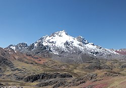 Rajuntay, one of the highest mountains of the Marcapomacocha District, as seen from the west | |
| Country |  Peru Peru |
| Region | Junín |
| Province | Yauli |
| Capital | Marcapomacocha |
| Government | |
| • Mayor | José Luis Rondon Mateo |
| Area | |
| • Total | 888.56 km2 (343.07 sq mi) |
| Elevation | 4,415 m (14,485 ft) |
| Population (2005 census) | |
| • Total | 1,001 |
| • Density | 1.1/km2 (2.9/sq mi) |
| Time zone | UTC-5 (PET) |
| UBIGEO | 120804 |
Marcapomacocha District is one of ten districts of the Yauli Province in the Junín Region in Peru.[1]
Geography
Some of the highest mountains of the district are listed below:[2]
- Alma Waqana
- Anta Q'asa
- Atuq Wachanan
- Chakra
- Chunta
- Ch'uyku
- Hanka Pata
- Hirka Kancha
- Jitpa
- Kashpi
- Kunkash
- Kuntur Puñuna
- Kuntur Sinqa
- Kuntur Wayin
- Lashwal
- Lichiqucha
- Liyunqucha
- Marayniyuq
- Mishipa Ñawin
- Muruqucha
- Nina Rupha
- Panapa Shapran
- Pillu
- Pinkuylluyuq
- Puka Rumi
- Pukaqucha
- Putaqa
- Phiruru
- Qallas
- Qiwllaqucha
- Qullpa P'iti
- Qullpayuq
- Qunchupata
- Quri Wayi
- Quriqucha
- Ranra Mach'ay
- Ranti Kancha
- Rajuntay
- Sillaqaqa
- Shaywa
- Uqhu
- Waman Marka
- Wankash
- Waqrash
- Warmis
- Wiskas
- Yana Kancha
- Yana Qaqa
- Yana Ulla
- Yuraq Allpa
- Yuraq Chaka
- Yuraqqucha
Climate
| Climate data for Marcapomacocha, elevation 4,447 m (14,590 ft), (1991–2020) | |||||||||||||
|---|---|---|---|---|---|---|---|---|---|---|---|---|---|
| Month | Jan | Feb | Mar | Apr | May | Jun | Jul | Aug | Sep | Oct | Nov | Dec | Year |
| Mean daily maximum °C (°F) | 10.8 (51.4) | 10.6 (51.1) | 10.5 (50.9) | 10.9 (51.6) | 11.1 (52.0) | 10.8 (51.4) | 10.8 (51.4) | 11.5 (52.7) | 11.5 (52.7) | 11.5 (52.7) | 11.9 (53.4) | 11.1 (52.0) | 11.1 (51.9) |
| Mean daily minimum °C (°F) | 0.5 (32.9) | 0.7 (33.3) | 0.8 (33.4) | 0.1 (32.2) | −1.2 (29.8) | −2.7 (27.1) | −3.8 (25.2) | −3.4 (25.9) | −2.0 (28.4) | −0.8 (30.6) | −0.5 (31.1) | 0.3 (32.5) | −1.0 (30.2) |
| Average precipitation mm (inches) | 140.0 (5.51) | 150.9 (5.94) | 171.6 (6.76) | 81.0 (3.19) | 34.8 (1.37) | 12.4 (0.49) | 12.1 (0.48) | 17.4 (0.69) | 41.7 (1.64) | 71.3 (2.81) | 81.3 (3.20) | 114.0 (4.49) | 928.5 (36.57) |
| Source: National Meteorology and Hydrology Service of Peru[3] | |||||||||||||
| Climate data for Yantac, Marcapomacocha, elevation 4,617 m (15,148 ft), (1991–2020) | |||||||||||||
|---|---|---|---|---|---|---|---|---|---|---|---|---|---|
| Month | Jan | Feb | Mar | Apr | May | Jun | Jul | Aug | Sep | Oct | Nov | Dec | Year |
| Mean daily maximum °C (°F) | 8.8 (47.8) | 8.6 (47.5) | 8.7 (47.7) | 9.2 (48.6) | 9.8 (49.6) | 10.5 (50.9) | 10.6 (51.1) | 10.8 (51.4) | 9.9 (49.8) | 9.5 (49.1) | 9.6 (49.3) | 8.8 (47.8) | 9.6 (49.2) |
| Mean daily minimum °C (°F) | 0.6 (33.1) | 0.7 (33.3) | 0.7 (33.3) | 0.5 (32.9) | −0.6 (30.9) | −2.3 (27.9) | −2.9 (26.8) | −2.8 (27.0) | −0.7 (30.7) | 0.5 (32.9) | 0.4 (32.7) | 0.6 (33.1) | −0.4 (31.2) |
| Average precipitation mm (inches) | 128.0 (5.04) | 134.4 (5.29) | 133.1 (5.24) | 73.9 (2.91) | 31.0 (1.22) | 13.5 (0.53) | 15.1 (0.59) | 23.7 (0.93) | 48.4 (1.91) | 79.7 (3.14) | 80.6 (3.17) | 113.3 (4.46) | 874.7 (34.43) |
| Source: National Meteorology and Hydrology Service of Peru[3] | |||||||||||||
See also
- Aququcha
- Markapumaqucha
- Markaqucha
- P'ukruqucha
References
- ^ (in Spanish) Instituto Nacional de Estadística e Informática. Banco de Información Distrital Archived 2008-04-23 at the Wayback Machine. Retrieved April 11, 2008.
- ^ escale.minedu.gob.pe - UGEL map of the Yauli Province (Junín Region)
- ^ a b "Normales Climáticas Estándares y Medias 1991-2020". National Meteorology and Hydrology Service of Peru. Archived from the original on 21 August 2023. Retrieved 17 June 2024.
- v
- t
- e

- Districts of Junín Region
- Peru

- Carhuacallanga
- Chacapampa
- Chicche
- Chilca
- Chongos Alto
- Chupuro
- Colca
- Cullhuas
- El Tambo
- Huacrapuquio
- Hualhuas
- Huancan
- Huancayo
- Huasicancha
- Huayucachi
- Ingenio
- Pariahuanca
- Pilcomayo
- Pucará
- Quichuay
- Quilcas
- San Agustín de Cajas
- San Jerónimo de Tunán
- San Pedro de Saño
- Santo Domingo de Acobamba
- Sapallanga
- Sicaya
- Viques
- Acolla
- Apata
- Ataura
- Canchayllo
- Curicaca
- El Mantaro
- Huamalí
- Huaripampa
- Huertas
- Janjaillo
- Jauja
- Julcán
- Leonor Ordóñez
- Llocllapampa
- Marco
- Masma
- Masma Chicche
- Molinos
- Monobamba
- Muqui
- Muquiyauyo
- Paca
- Paccha
- Pancán
- Parco
- Pomacancha
- Ricran
- San Lorenzo
- San Pedro de Chunan
- Sausa
- Sincos
- Tunan Marca
- Yauli
- Yauyos
 | This Junín Region geography article is a stub. You can help Wikipedia by expanding it. |
- v
- t
- e


