Manternach
Commune in Grevenmacher, Luxembourg
Manternach Manternach | |
|---|---|
 | |
 Coat of arms | |
 Map of Luxembourg with Manternach highlighted in orange, and the canton in dark red | |
| Coordinates: 49°42′25″N 6°25′25″E / 49.7069°N 6.4236°E / 49.7069; 6.4236 | |
| Country |  Luxembourg Luxembourg |
| Canton | Grevenmacher |
| Area | |
| • Total | 27.68 km2 (10.69 sq mi) |
| • Rank | 30th of 100 |
| Highest elevation | 341 m (1,119 ft) |
| • Rank | 87th of 100 |
| Lowest elevation | 181 m (594 ft) |
| • Rank | 17th of 100 |
| Population (2023) | |
| • Total | 2,298 |
| • Rank | 69th of 100 |
| • Density | 83/km2 (220/sq mi) |
| • Rank | 77th of 100 |
| Time zone | UTC+1 (CET) |
| • Summer (DST) | UTC+2 (CEST) |
| LAU 2 | LU0001106 |
| Website | manternach.lu |
Manternach is a commune and small town in eastern Luxembourg. It is part of the canton of Grevenmacher.
As of 2024[update], the town of Manternach, which lies in the south of the commune, has a population of 728.[1] Other towns within the commune include Berbourg, Lellig, and Munschecker.
Manternach railway station has regular services directly to Luxembourg City and Wasserbillig. There are normally 35 trains per day travelling from Manternach to Luxembourg[2]
Population
Graphs are unavailable due to technical issues. There is more info on Phabricator and on MediaWiki.org. |
Image gallery
-
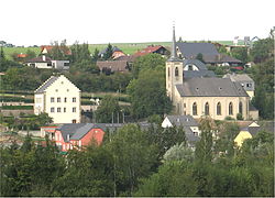
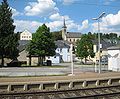 Manternach, seen from the railway station

References
External links
 Media related to Manternach at Wikimedia Commons
Places adjacent to Manternach | ||||||||||||||||
|---|---|---|---|---|---|---|---|---|---|---|---|---|---|---|---|---|
| ||||||||||||||||


- v
- t
- e
- Betzdorf
- Biwer
- Flaxweiler
- Grevenmacher
- Junglinster
- Manternach
- Mertert
- Wormeldange
| Authority control databases |
|
|---|
 | This article related to the geography of Grevenmacher canton is a stub. You can help Wikipedia by expanding it. |
- v
- t
- e


