Macharen
Village in North Brabant, Netherlands
51°48′18″N 5°32′39″E / 51.80500°N 5.54417°E / 51.80500; 5.54417 (2021)[1]
5367[1]
Macharen is a village in the southern part of the Netherlands, in the province North Brabant. It is part of the Oss municipality.
The village was first mentioned in 1107 as Machera, and means "suitable sandy ridge".[3]
The Catholic St Petrus Bandenkerk was built between 1862 and 1867, however the tower dates from the 15th century.[4]
Macharen was home to 389 people in 1840.[4] Macharen originally was a part of the county Megen, which was founded around 1145. In 1810, it became municipality together with Megen and Haren. It became a part of the municipality Oss in 1994.[4]
Gallery
-
 Clergy house
 -
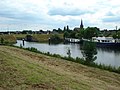 View on Macharen
 -
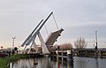 Bridge in Macharen


References
- ^ a b c "Kerncijfers wijken en buurten 2021". Central Bureau of Statistics. Retrieved 18 April 2022.
- ^ "Postcodetool for 5367AA". Actueel Hoogtebestand Nederland (in Dutch). Het Waterschapshuis. Retrieved 18 April 2022.
- ^ "Macharen - (geografische naam)". Etymologiebank (in Dutch). Retrieved 18 April 2022.
- ^ a b c "Macharen". Plaatsengids (in Dutch). Retrieved 18 April 2022.
 | This North Brabant location article is a stub. You can help Wikipedia by expanding it. |
- v
- t
- e


