Mỹ Tho
You can help expand this article with text translated from the corresponding article in Vietnamese. (October 2023) Click [show] for important translation instructions.
- Machine translation, like DeepL or Google Translate, is a useful starting point for translations, but translators must revise errors as necessary and confirm that the translation is accurate, rather than simply copy-pasting machine-translated text into the English Wikipedia.
- Consider adding a topic to this template: there are already 953 articles in the main category, and specifying
|topic=will aid in categorization. - Do not translate text that appears unreliable or low-quality. If possible, verify the text with references provided in the foreign-language article.
- You must provide copyright attribution in the edit summary accompanying your translation by providing an interlanguage link to the source of your translation. A model attribution edit summary is
Content in this edit is translated from the existing Vietnamese Wikipedia article at [[:vi:Mỹ Tho]]; see its history for attribution. - You may also add the template
{{Translated|vi|Mỹ Tho}}to the talk page. - For more guidance, see Wikipedia:Translation.
City in Tiền Giang, Vietnam
Mỹ Tho Thành phố Mỹ Tho | |
|---|---|
City (Class-1) | |
| Mỹ Tho City | |
 Mỹ Tho, Mekong Delta, Vietnam | |
| Seal | |
 | |
10°21′N 106°21′E / 10.350°N 106.350°E / 10.350; 106.350 | |
| Country |  Vietnam Vietnam |
| Province | Tiền Giang |
| Area | |
| • Total | 31.49 sq mi (81.55 km2) |
| Population (2019) | |
| • Total | 270,700 |
| • Density | 8,600/sq mi (3,300/km2) |
| Area code(s) | 073, 074 (nation) and +8473,+8474 (international) |
| Climate | Aw |
| Website | mytho |
Mỹ Tho (listenⓘ) is a city in the Tiền Giang province in the Mekong Delta region of South Vietnam. It has a population of approximately 169,000 in 2006[1] and 220,000 in 2012.[2] It is the regional center of economics, education and technology.[3] The majority ethnic group is the Kinh; minority groups include the Hoa, the Cham and the Khmer people. Boat rides on the Mỹ Tho River are popular with tourists, and the city is known for hủ tiếu Mỹ Tho, a type of rice noodles soup.[4]
History

Mỹ Tho was founded in the 1680s by Chinese refugees fleeing China after the fall of remnants of the Southern Ming to the Qing dynasty in 1683. The city is named after the Mỹ Tho River. In chữ Hán, the name is given as 美萩 (literally, beautiful tree).[5]
Due to its proximity to Saigon, Mỹ Tho was the traditional gateway to the Mekong Delta. In the 17th century, the city had become one of the biggest commercial hubs in today's Southern Vietnam.
In the 1860s, Mỹ Tho, along with Saigon, was a major strategic city during the French colonial campaign towards Vietnam. In 1862, France's capture of Mỹ Tho is regarded as the conclusion to the establishment of the French colony of Cochinchina, a development that inaugurated nearly a century of French colonial dominance in Vietnam. During the colonization period, the economy continued to prosper, attracting more immigrants, mainly from Teochew and Minnan of mainland China.
Mỹ Tho City is recognized as a grade II on October 7, 2005.[6]
Administrative divisions
Mỹ Tho is divided to 11 wards (called Ward 1 - Ward 10, and Ward Tân Long) and 6 communes.[7]
6 communes:
- Đạo Thạnh
- Mỹ Phong
- Phước Thạnh
- Tân Mỹ Chánh
- Thới Sơn
- Trung An
- Phước Thạnh
Transportation
Mỹ Tho is connected to the rest of the country by National Route 1 and Tiền River. Here, people mainly use motorcycles, bicycles, and boats for transportation. Mỹ Tho has the first railway route (about 70 kilometres (43 mi) long) in Vietnam which was one of the most modern transport means in the world linking Saigon and Mỹ Tho, put into use in 1885. However, it was destroyed in the 1960s during Vietnam War.[8]
By road, Mỹ Tho City is 70 kilometres (43 mi) from Vĩnh Long province, 70 kilometres (43 mi) from Ho Chi Minh City, regional center of Southern Vietnam, 103 kilometres (64 mi) from Cần Thơ, 179 kilometres (111 mi) from Châu Đốc, 182 kilometres (113 mi) from Rạch Giá,[9] 132 kilometres (82 mi) from Long Xuyên.[10] Mỹ Tho and Bến Tre are connected by Rạch Miễu Bridge.
By river, there are many short boat trips to various islands, Bến Tre, and floating markets[11] in the surrounding areas. It also has overnight long boats to Châu Đốc and Long Xuyên.
Climate
| Climate data for Mỹ Tho | |||||||||||||
|---|---|---|---|---|---|---|---|---|---|---|---|---|---|
| Month | Jan | Feb | Mar | Apr | May | Jun | Jul | Aug | Sep | Oct | Nov | Dec | Year |
| Record high °C (°F) | 34.8 (94.6) | 35.1 (95.2) | 36.8 (98.2) | 38.2 (100.8) | 38.9 (102.0) | 36.4 (97.5) | 36.5 (97.7) | 35.8 (96.4) | 36.8 (98.2) | 35.5 (95.9) | 36.2 (97.2) | 34.5 (94.1) | 38.9 (102.0) |
| Mean daily maximum °C (°F) | 30.2 (86.4) | 30.9 (87.6) | 32.2 (90.0) | 33.6 (92.5) | 33.3 (91.9) | 32.2 (90.0) | 31.7 (89.1) | 31.5 (88.7) | 31.3 (88.3) | 30.9 (87.6) | 30.8 (87.4) | 30.2 (86.4) | 31.6 (88.9) |
| Daily mean °C (°F) | 25.5 (77.9) | 26.1 (79.0) | 27.3 (81.1) | 28.6 (83.5) | 28.4 (83.1) | 27.7 (81.9) | 27.3 (81.1) | 27.1 (80.8) | 27.0 (80.6) | 26.8 (80.2) | 26.7 (80.1) | 25.8 (78.4) | 27.1 (80.8) |
| Mean daily minimum °C (°F) | 22.2 (72.0) | 22.8 (73.0) | 24.2 (75.6) | 25.4 (77.7) | 25.6 (78.1) | 25.0 (77.0) | 24.6 (76.3) | 24.6 (76.3) | 24.6 (76.3) | 24.3 (75.7) | 23.8 (74.8) | 22.6 (72.7) | 24.1 (75.4) |
| Record low °C (°F) | 14.9 (58.8) | 15.9 (60.6) | 15.7 (60.3) | 19.4 (66.9) | 21.5 (70.7) | 21.2 (70.2) | 19.6 (67.3) | 21.2 (70.2) | 21.2 (70.2) | 19.9 (67.8) | 17.6 (63.7) | 16.1 (61.0) | 14.9 (58.8) |
| Average rainfall mm (inches) | 8.1 (0.32) | 1.8 (0.07) | 6.6 (0.26) | 41.3 (1.63) | 149.7 (5.89) | 203.2 (8.00) | 189.2 (7.45) | 192.6 (7.58) | 231.3 (9.11) | 263.7 (10.38) | 95.4 (3.76) | 35.6 (1.40) | 1,419.7 (55.89) |
| Average rainy days | 1.6 | 0.6 | 1.3 | 4.4 | 14.9 | 18.7 | 20.0 | 20.2 | 20.3 | 19.6 | 10.5 | 5.8 | 137.5 |
| Average relative humidity (%) | 79.2 | 78.4 | 78.4 | 78.0 | 81.4 | 83.1 | 83.7 | 84.3 | 85.0 | 85.3 | 83.2 | 81.4 | 82.2 |
| Mean monthly sunshine hours | 244.1 | 249.3 | 284.9 | 261.5 | 209.8 | 180.7 | 188.5 | 187.9 | 165.4 | 170.5 | 198.5 | 198.0 | 2,531.1 |
| Source: Vietnam Institute for Building Science and Technology[12] | |||||||||||||
Tourism

Vĩnh Tràng Temple,[13] Cao Dai Temple,[7] Dong Tam Snake Farm.[14] There are four islands in the Tien River between Mỹ Tho and Bến Tre: Dragon (Con Rong), Tortoise (Con Qui), Phoenix (Con Phung) and Unicorn (Con Lan) Islands.[15]
The Mekong Delta is considered to be the "rice basket of Vietnam", contributing more than half of the nation's rice production. Mỹ Tho is well known as floating markets, where people sell and buy things on the river, as well as Ben Tam Ngua and Mỹ Thuận market.
Education
Mỹ Tho was the first town in southern Vietnam to have a high school. The Collège de Mỹ Tho, opened in March 1879, is now called Nguyễn Đình Chiểu High School. It was one of the first schools Vietnam had, and even now is still known for its education quality among Southern schools.
Later, another school called "School for Gifted Students of Tien Giang" opened in Mỹ Tho city. Though the total area is very limited compared to other schools in the province, the quality of education there is usually considered one of the best. The curriculum they use is modified so that students usually learn more of their core subjects than in other schools. For instance, students from a Math class do all the required materials like any other classes, but more of Chemistry, Biology, and Physics because they are in the Natural Science block, and a lot more of Math. Preparation for national exams and entrance examination to the university are prioritized there.
Schools in Mỹ Tho are named after famous Vietnamese writers, poets, and national heroes such as Nguyễn Trãi, Thu Khoa Huan is also known as Nguyen Huu Huan, Xuân Diệu, Lê Ngọc Hân, Nguyễn Đình Chiểu, Trần Hưng Đạo.
Tiền Giang College which was promoted to Tiền Giang University in 2005[16] is also located at Mỹ Tho.
Economy
Today the economy of Mỹ Tho is mainly based on tourism, fishing, and agricultural products such as coconuts, bananas, and longans.[17]
During World War II the French Vichy government interned foreign nationals in Mỹ Tho. In May 1945, the Japanese seized control of the camps fearing an allied attack. Foreign nationals were confined throughout the war. As the regional capital, Mỹ Tho is the main market dealing in all the produce from the region as well as fish and other seafood from Mỹ Tho's large ocean-going fishing fleet. The very large and exuberant market is one of South Vietnam's biggest sources for dried fish and other dried seafood products such as Kho Muc (dried squid). At night the market is dedicated to the dealing and sorting of Mekong River fish, particularly catfish for Hồ Chí Minh City's wholesale markets. Produce, especially fruit and vegetables, is delivered by boat directly to markets. It is a popular starting point for tourists to take a boat trip on the Mekong River.
Mỹ Tho was the subject of "The Lesson", a chapter in a memoir by Tobias Wolff, In Pharaoh's Army: Memories of the Lost War, describing the events of the 1968 Tet Offensive there.[18]
In 2010, there are total 17 markets located in wards and commune in Mỹ Tho.[2]
Neighbouring cities
- West and North: Chợ Gạo District
- East: Châu Thành District, Tiền Giang
- South: Tiền River and Bến Tre province
Notable people
- Nguyễn Thị Thập - Chairman of the Women's Federation of Vietnam (Hội liên hiệp phụ nữ Việt Nam) from 1956 to 1974
- General Nguyễn Khánh - former Prime Minister, General, and Ambassador of South Vietnam
- General Nguyễn Hữu Hạnh - served in the Army of the Republic of Vietnam
- Madame Thiệu, the last serving First Lady of South Vietnam from 1967 to 1975 and wife of the President of South Vietnam Nguyễn Văn Thiệu
- Trần Anh Hùng – film director and screenwriter
Gallery
-
 House on Bank of Mekong
 -
 The downtown of Mỹ Tho
 -
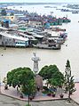 The center of Mỹ Tho with Nguyen Huu Huan statue
 -
 The waterfront houses in Mỹ Tho
 -
 The waterfront shops.
 -
 Rach Mieu Ferry in 2002, now expired.


References
- ^ Hoskin, John; Howland, Carol (2006). Vietnam. New Holland. p. 114. ISBN 9781845375515.
- ^ a b mrdanial (2012-08-09). "Get to Know the Door of Mekong Region – My Tho City". The Vietnam Guide. Archived from the original on 2017-03-15. Retrieved 2013-08-22.
- ^ "Thành phố Mỹ Tho". Mythocity.gov.vn. Archived from the original on 2013-09-01. Retrieved 2013-08-22.
- ^ Writer), Nick Ray (Travel (2009). Lonely Planet Vietnam. Lonely Planet Publications. p. 418. ISBN 9781742203898.
- ^ "Vietnamese Nôm Preservation Foundation". Nomfoundation.org. Retrieved 2013-08-22.
- ^ "My Tho grade II". Thevietnamguide.com. Archived from the original on 2017-03-15. Retrieved 2013-02-05.
- ^ a b "My Tho". Amitourist.com. Archived from the original on 2018-01-11. Retrieved 2013-02-21.
- ^ "The First Railway Route in Vietnam". tuoitrenews.vn.
- ^ "Provinces and cities". Vietnamtourism.com. Archived from the original on 2010-02-10. Retrieved 2013-08-22.
- ^ "My Tho - Long Xuyen". Google Maps.
- ^ "Floating Markets, Mekong River, Mekong delta, Mekong travel guide, Mekong river travel guide". Luxury Mekong River Cruise. Retrieved 2013-08-22.
- ^ "Vietnam Institute for Building Science and Technology" (PDF).
- ^ Vo Van Tuon & Huynh Nhu Phuong "VIETNAMESE'S FAMOUS PAGODAS". Art Publisher. 1995. Archived from the original on February 27, 2001. Retrieved February 4, 2013.
- ^ Trea, Tuoi (February 10, 2013). "A visit to the Dong Tam Snake Farm". Archived from the original on February 14, 2013. Retrieved February 17, 2013.
- ^ "My Tho". www.footprinttravelguides.com. Archived from the original on 14 February 2014. Retrieved 14 June 2015.
- ^ Raby, Rosalind Latiner; Valeau, Edward J. (2009-03-22). Vietnam community colleges. Springer. ISBN 9781402094774.
- ^ "MY THO - VIETNAM - MEKONG RIVER". www.luxurymekongrivercruise.com. Retrieved 14 June 2015.
- ^ Wolff, Tobias (1995). In Pharaoh's Army: Memories of the Lost War. Knopf. ISBN 9780307763754.
External links
Wikimedia Commons has media related to My Tho.
- Official website
10°21′N 106°21′E / 10.350°N 106.350°E / 10.350; 106.350
- v
- t
- e
Cities in Vietnam
| Special |
|
|---|---|
| Class-1 |
| Class-1 |
|---|
| Class-1 | |
|---|---|
| Class-2 | |
| Class-3 |
|
Districts of the Mekong Delta | ||
|---|---|---|
| Cần Thơ city |  | |
| An Giang province | ||
| Bạc Liêu province | ||
| Bến Tre province | ||
| Cà Mau province | ||
| Đồng Tháp province |
| |
| Hậu Giang province |
| |
| Kiên Giang province | ||
| Long An province | ||
| Sóc Trăng province | ||
| Tiền Giang province |
| |
| Trà Vinh province | ||
| Vĩnh Long province | ||
※ denotes provincial seat. | ||
| |
|---|---|
| 2,000,000 and more |
|
| 1,000,000–1,999,999 | |
| 500,000–999,999 | |
| 200,000–499,999 | |
Authority control databases | |
|---|---|
| International |
|
| National |
|
| Geographic |
|
| Other |
|


