Lontzen
Municipality in German-speaking Community of Belgium, Belgium

Flag

Coat of arms
Location of Lontzen


Lontzen
Location in Belgium 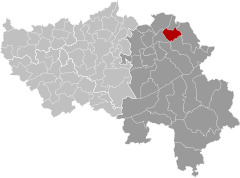
Location of Lontzen in the province of Liège

 Belgium
 German-speaking Community of Belgium
 (2018-01-01)[1]
4710-4711
63048
Lontzen (German pronunciation: [ˈlɔntsn̩]) is a municipality located in East Belgium. On January 1, 2018 Lontzen had a total population of 5,695. The total area is 28.73 km2 which gives a population density of 198 inhabitants per km2.
The municipality consists of the following sub-municipalities: Lontzen proper, Herbesthal, and Walhorn.
In the 19th century, a Low Franconian dialect was widely spoken in Lontzen.
See also
References
- ^ "Wettelijke Bevolking per gemeente op 1 januari 2018". Statbel. Retrieved 9 March 2019.
External links
 Media related to Lontzen at Wikimedia Commons
- Official web page (in German and French)
Places adjacent to Lontzen | ||||||||||||||||
|---|---|---|---|---|---|---|---|---|---|---|---|---|---|---|---|---|
| ||||||||||||||||


- v
- t
- e
Municipalities in the province of Liège, Wallonia

- Bold indicates cities
- Italic indicates municipalities with language facilities
Authority control databases | |
|---|---|
| International |
|
| Geographic |
|
 | This Liège Province location article is a stub. You can help Wikipedia by expanding it. |
- v
- t
- e


