List of historic places in Essex County, Ontario
Map all coordinates using OpenStreetMap
Download coordinates as:
- KML
- GPX (all coordinates)
- GPX (primary coordinates)
- GPX (secondary coordinates)
This is a list of historic places in Essex County, Ontario, containing heritage sites listed on the Canadian Register of Historic Places (CRHP), all of which are designated as historic places either locally, provincially, territorially, nationally, or by more than one level of government.
List of historic places
| Name | Address | Coordinates | Government recognition (CRHP №) | Image | |
|---|---|---|---|---|---|
| Amherstburg First Baptist Church National Historic Site of Canada | 232 George Street Amherstburg ON | 42°06′10″N 83°06′20″W / 42.1027°N 83.1055°W / 42.1027; -83.1055 (Amherstburg First Baptist Church National Historic Site of Canada) | Federal (19445) |  | |
| Amherstburg Navy Yard National Historic Site of Canada | Dalhousie Street Amherstburg ON | 42°06′13″N 83°06′51″W / 42.1035°N 83.1143°W / 42.1035; -83.1143 (Amherstburg Navy Yard National Historic Site of Canada) | Federal (13965) |  More images | |
| Belle Vue National Historic Site of Canada | 525 Dalhousie Street Amherstburg ON | 42°05′31″N 83°06′45″W / 42.0919°N 83.1126°W / 42.0919; -83.1126 (Belle Vue National Historic Site of Canada) | Federal (1164) |  More images | |
| Bois Blanc Island Lighthouse and Blockhouse National Historic Site of Canada | Amherstburg ON | 42°05′13″N 83°07′11″W / 42.087°N 83.1197°W / 42.087; -83.1197 (Bois Blanc Island Lighthouse and Blockhouse National Historic Site of Canada) | Federal (16144, (20662) |  More images | |
| Brick Barrack | 100 Laird Avenue South Amherstburg ON | 42°06′25″N 83°06′47″W / 42.107°N 83.113°W / 42.107; -83.113 (Brick Barrack) | Federal (4364) |  Upload Photo | |
| Christ Church Amherstburg (Anglican) | 317 Ramsay Street Amherstburg ON | 42°06′00″N 83°06′39″W / 42.1000°N 83.1107°W / 42.1000; -83.1107 (Christ Church Amherstburg (Anglican)) | Ontario (10177) | Upload Photo | |
| Commissariat Office / Callum House (Amherstburg Navy Yard) | Dalhousie Street, Navy Yard Park Amherstburg ON | 42°06′12″N 83°06′49″W / 42.1032°N 83.1137°W / 42.1032; -83.1137 (Commissariat Office / Callum House) | Federal (4367) | 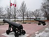 | |
| Fort Malden National Historic Site of Canada | 100 Laird Avenue South Amherstburg ON | 42°06′26″N 83°06′48″W / 42.1072°N 83.1134°W / 42.1072; -83.1134 (Fort Malden National Historic Site of Canada) | Federal (7615) |  | |
| Hough House | 100 Laird Avenue South Amherstburg ON | 42°06′26″N 83°06′48″W / 42.1071°N 83.1134°W / 42.1071; -83.1134 (Hough House) | Federal (4370) |  More images | |
| Lighthouse | Bois Blanc Island Amherstburg ON | 42°05′13″N 83°07′11″W / 42.087°N 83.1197°W / 42.087; -83.1197 (Lighthouse) | Federal (4479) | 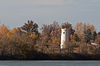 | |
| Nazrey African Methodist Episcopal Church National Historic Site of Canada | 271 King Street Amherstburg ON | 42°06′04″N 83°06′21″W / 42.1011°N 83.1057°W / 42.1011; -83.1057 (Nazrey African Methodist Episcopal Church National Historic Site of Canada) | Federal (6054) | 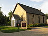 More images | |
| Visitor Orientation Centre | 100 Laird Avenue South Amherstburg ON | 42°06′25″N 83°06′47″W / 42.107°N 83.113°W / 42.107; -83.113 (Visitor Orientation Centre) | Federal (4480) | Upload Photo | |
| Canadian National Railways Station | Maple Street Comber ON | 42°14′11″N 82°33′03″W / 42.2364°N 82.5509°W / 42.2364; -82.5509 (Canadian National Railways Station (Comber)) | Federal (4615) |  More images | |
| Canadian National Railway Station | Marlborough Street West and M C R Drive Leamington ON | 42°03′02″N 82°36′26″W / 42.0506°N 82.6071°W / 42.0506; -82.6071 (Canadian National Railway Station (Leamington)) | Federal (7885) | Upload Photo | |
| Delaurier House | Point Pelee Leamington ON | 41°56′49″N 82°30′50″W / 41.947°N 82.514°W / 41.947; -82.514 (Delaurier House) | Federal (4764) | Upload Photo | |
| Southeast Shoal Dwelling | Point Pelee Leamington ON | 41°57′24″N 82°25′21″W / 41.9567°N 82.4225°W / 41.9567; -82.4225 (Southeast Shoal Dwelling) | Federal (4751) | Upload Photo | |
| 534 Kildare Road | 534 Kildare Road Windsor ON | 42°19′24″N 83°00′48″W / 42.3233°N 83.0132°W / 42.3233; -83.0132 (534 Kildare Road) | Windsor municipality (8477) |  More images | |
| 536 Kildare Road | 536 Kildare Road Windsor ON | 42°19′24″N 83°00′47″W / 42.3232°N 83.0131°W / 42.3232; -83.0131 (536 Kildare Road) | Windsor municipality (8478) |  More images | |
| 546-548 Devonshire Road | 546-548 Devonshire Road Windsor ON | 42°19′25″N 83°00′43″W / 42.3236°N 83.012°W / 42.3236; -83.012 (546-548 Devonshire Road) | Windsor municipality (5616) | 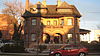 More images | |
| 650 Devonshire Road | 650 Devonshire Road Windsor ON | 42°19′22″N 83°00′41″W / 42.3227°N 83.0114°W / 42.3227; -83.0114 (650 Devonshire Road) | Windsor municipality (8326) | 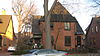 More images | |
| 656 Devonshire Road | 656 Devonshire Road Windsor ON | 42°19′21″N 83°00′41″W / 42.3226°N 83.0114°W / 42.3226; -83.0114 (656 Devonshire Road) | Windsor municipality (8327) | | |
| 704 Monmouth Road | 704 Monmouth Road Windsor ON | 42°19′22″N 83°00′32″W / 42.3229°N 83.0088°W / 42.3229; -83.0088 (704 Monmouth Road) | Windsor municipality (8328) |  More images | |
| 716 Monmouth Road | 716 Monmouth Road Windsor ON | 42°19′22″N 83°00′31″W / 42.3228°N 83.0087°W / 42.3228; -83.0087 (716 Monmouth Road) | Windsor municipality (8376) | | |
| 721 Walker Road | 721 Walker Road Windsor ON | 42°19′23″N 83°00′30″W / 42.323°N 83.0082°W / 42.323; -83.0082 (721 Walker Road) | Windsor municipality (8377) |  More images | |
| 731 Walker Road | 731 Walker Road Windsor ON | 42°19′22″N 83°00′29″W / 42.3229°N 83.0081°W / 42.3229; -83.0081 (731 Walker Road) | Windsor municipality (15159) |  More images | |
| 739 Walker Road | 739 Walker Road Windsor ON | 42°19′22″N 83°00′29″W / 42.3228°N 83.0081°W / 42.3228; -83.0081 (739 Walker Road) | Windsor municipality (8378) |  More images | |
| 744 Monmouth Road | 744 Monmouth Road Windsor ON | 42°19′21″N 83°00′31″W / 42.3226°N 83.0086°W / 42.3226; -83.0086 (744 Monmouth Road) | Windsor municipality (8379) | 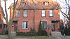 More images | |
| 749 Walker Road | 749 Walker Road Windsor ON | 42°19′22″N 83°00′29″W / 42.3228°N 83.008°W / 42.3228; -83.008 (749 Walker Road) | Windsor municipality (16328) |  More images | |
| 753 Walker Road | 753 Walker Road Windsor ON | 42°19′22″N 83°00′29″W / 42.3227°N 83.008°W / 42.3227; -83.008 (753 Walker Road) | Windsor municipality (15160) | 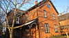 More images | |
| 756 Monmouth Road | 756 Monmouth Road Windsor ON | 42°19′21″N 83°00′31″W / 42.3225°N 83.0085°W / 42.3225; -83.0085 (756 Monmouth Road) | Windsor municipality (15216) | | |
| 763 Walker Road | 763 Walker Road Windsor ON | 42°19′21″N 83°00′29″W / 42.3226°N 83.008°W / 42.3226; -83.008 (763 Walker Road) | Windsor municipality (15214) | 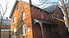 More images | |
| Abner F. Nash House | 694 Victoria Avenue Windsor ON | 42°18′45″N 83°02′16″W / 42.3124°N 83.0377°W / 42.3124; -83.0377 (Abner F. Nash House) | Windsor municipality (8382) | Upload Photo | |
| Addyman-Ould House | 904 Lawrence Road Windsor ON | 42°19′27″N 82°58′39″W / 42.3243°N 82.9776°W / 42.3243; -82.9776 (Addyman-Ould House) | Windsor municipality (8829) | Upload Photo | |
| Arthur and Marie Langlois House | 351 Mill Street Windsor ON | 42°18′05″N 83°04′29″W / 42.3014°N 83.0747°W / 42.3014; -83.0747 (Arthur and Marie Langlois House) | Windsor municipality (8546) |  More images | |
| Assumption Church | 350 Huron Church Road Windsor ON | 42°18′26″N 83°04′11″W / 42.3073°N 83.0698°W / 42.3073; -83.0698 (Assumption Church) | Windsor municipality (7682) |  More images | |
| Assumption Church (Roman Catholic) | 350 Huron Church Road Windsor ON | 42°18′27″N 83°04′11″W / 42.3075°N 83.0698°W / 42.3075; -83.0698 (Assumption Church (Roman Catholic)) | Ontario (9942) | More images | |
| Assumption Park | 1902 Riverside Drive Windsor ON | 42°18′37″N 83°04′16″W / 42.3102°N 83.0711°W / 42.3102; -83.0711 (Assumption Park) | Windsor municipality (8547) | 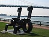 | |
| Baby-Lajeunesse House | 3402 Sandwich Street Windsor ON | 42°17′51″N 83°04′43″W / 42.2975°N 83.0787°W / 42.2975; -83.0787 (Baby-Lajeunesse House) | Windsor municipality (8548) |  More images | |
| Bank of Montreal Building | 1799 Wyandotte Street East Windsor ON | 42°19′19″N 83°00′51″W / 42.322°N 83.0141°W / 42.322; -83.0141 (Bank of Montreal Building) | Windsor municipality (7605) | 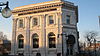 More images | |
| Bedford United Church | 3340 Sandwich Street Windsor ON | 42°17′56″N 83°04′41″W / 42.2989°N 83.0781°W / 42.2989; -83.0781 (Bedford United Church) | Windsor municipality (10783) |  More images | |
| Charles R. Cole House | 595 Cataraqui Street Windsor ON | 42°18′54″N 83°01′39″W / 42.3151°N 83.0274°W / 42.3151; -83.0274 (Charles R. Cole House) | Windsor municipality (7578) | Upload Photo | |
| The Cobbles-Victor Williamson House | 849 Kildare Road Windsor ON | 42°19′12″N 83°00′42″W / 42.32°N 83.0116°W / 42.32; -83.0116 (The Cobbles-Victor Williamson House) | Windsor municipality (8555) | 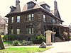 More images | |
| Crown Inn | 378-396 Devonshire Road Windsor ON | 42°19′29″N 83°00′47″W / 42.3247°N 83.0131°W / 42.3247; -83.0131 (Crown Inn) | Windsor municipality (7608) | 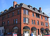 More images | |
| DeGurse-McEwen House | 537 Kildare Road Windsor ON | 42°19′22″N 83°00′49″W / 42.3229°N 83.0136°W / 42.3229; -83.0136 (DeGurse-McEwen House) | Windsor municipality (8359) | 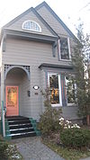 More images | |
| Devonshire Road Bank Building | 606-610 Devonshire Road Windsor ON | 42°19′23″N 83°00′42″W / 42.323°N 83.0117°W / 42.323; -83.0117 (Devonshire Road Bank Building) | Windsor municipality (5617) | 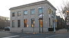 More images | |
| Dr. Charles W. Hoare House | 2088 Willistead Crescent Windsor ON | 42°19′04″N 83°00′29″W / 42.3179°N 83.0081°W / 42.3179; -83.0081 (Dr. Charles W. Hoare House) | Windsor municipality (15211) |  More images | |
| Dr. Freeman Brockenshire House | 1142 Kildare Road Windsor ON | 42°18′54″N 83°00′29″W / 42.3151°N 83.0081°W / 42.3151; -83.0081 (Dr. Freeman Brockenshire House) | Windsor municipality (14624) | 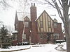 More images | |
| Dr. Henry Crassweller House | 2014 Willstead Crescent Windsor ON | 42°19′09″N 83°00′32″W / 42.3192°N 83.0089°W / 42.3192; -83.0089 (Dr. Henry Crassweller House) | Windsor municipality (8662) |  More images | |
| Dr. Neil MacDonald House | 2228 Victoria Avenue Windsor ON | 42°17′38″N 83°01′33″W / 42.2939°N 83.0257°W / 42.2939; -83.0257 (Dr. Neil MacDonald House) | Windsor municipality (8391) | Upload Photo | |
| Dr. Roy J. Coyle House | 2077 Willistead Crescent Windsor ON | 42°19′07″N 83°00′28″W / 42.3186°N 83.0079°W / 42.3186; -83.0079 (Dr. Roy J. Coyle House) | Windsor municipality (8392) | 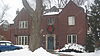 More images | |
| Dominion House Tavern | 3140 Sandwich Street Windsor ON | 42°18′13″N 83°04′31″W / 42.3036°N 83.0752°W / 42.3036; -83.0752 (Dominion House Tavern) | Windsor municipality (8666) |  More images | |
| Duff-Baby House | 221 Mill Street Windsor ON | 42°18′08″N 83°04′38″W / 42.3021°N 83.0771°W / 42.3021; -83.0771 (Duff-Baby House) | Ontario (8844), Windsor municipality (8393) |  More images | |
| Easton House | 2011 Willistead Crescent Windsor ON | 42°19′08″N 83°00′33″W / 42.3188°N 83.0091°W / 42.3188; -83.0091 (Easton House) | Windsor municipality (15206) | 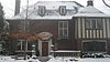 More images | |
| Elmscroft Carriage House | 823 Argyle Road Windsor ON | 42°19′16″N 83°00′36″W / 42.3212°N 83.0099°W / 42.3212; -83.0099 (Elmscroft Carriage House) | Windsor municipality (8409) | 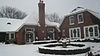 More images | |
| Ernest G. Henderson House | 803 Victoria Avenue Windsor ON | 42°18′40″N 83°02′14″W / 42.3110°N 83.0372°W / 42.3110; -83.0372 (Ernest G. Henderson House) | Windsor municipality (9053) | Upload Photo | |
| Esdras Parent House | 827 Esdras Place Windsor ON | 42°19′42″N 82°58′00″W / 42.3284°N 82.9666°W / 42.3284; -82.9666 (Esdras Parent House) | Windsor municipality (7589) | Upload Photo | |
| Federal Building | 185 Ouellette Avenue Windsor ON | 42°19′07″N 83°02′23″W / 42.3185°N 83.0396°W / 42.3185; -83.0396 (Federal Building) | Federal (11230) | Upload Photo | |
| Former John Richardson Library | 1495 Wyandotte Street West Windsor ON | 42°18′24″N 83°03′12″W / 42.3068°N 83.0532°W / 42.3068; -83.0532 (Former John Richardson Library) | Windsor municipality (8497) | Upload Photo | |
| Former Sandwich Fire Hall and Stable | 363 Mill Street Windsor ON | 42°18′05″N 83°04′29″W / 42.3014°N 83.0747°W / 42.3014; -83.0747 (Former Sandwich Fire Hall and Stable) | Windsor municipality (8498) |  More images | |
| Former Walkerville Post Office | 420 Devonshire Road Windsor ON | 42°19′28″N 83°00′44″W / 42.3244°N 83.0123°W / 42.3244; -83.0123 (Former Walkerville Post Office) | Windsor municipality (3374) |  More images | |
| Former Walkerville Town Hall | 350 Devonshire Road Windsor ON | 42°19′30″N 83°00′48″W / 42.3251°N 83.0132°W / 42.3251; -83.0132 (Former Walkerville Town Hall) | Windsor municipality (7683) |  More images | |
| Former Windsor - Essex County Family YMCA | 511 Pelissier Street Windsor ON | 42°18′53″N 83°02′19″W / 42.3146°N 83.0386°W / 42.3146; -83.0386 (Former Windsor - Essex County Family YMCA) | Windsor municipality (2250) | Upload Photo | |
| François Bâby House National Historic Site of Canada | 254 Pitt Street West Windsor ON | 42°19′07″N 83°02′30″W / 42.3185°N 83.0417°W / 42.3185; -83.0417 (François Bâby House National Historic Site of Canada) | Federal (12401), Windsor municipality (9557) | 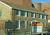 More images | |
| Frank H. Joyce House | 3975 Riverside Windsor ON | 42°19′35″N 82°59′21″W / 42.3263°N 82.9893°W / 42.3263; -82.9893 (Frank H. Joyce House) | Windsor municipality (14444) |  More images | |
| Frederick Allworth House | 825 Victoria Avenue Windsor ON | 42°18′38″N 83°02′15″W / 42.3106°N 83.0374°W / 42.3106; -83.0374 (Frederick Allworth House) | Windsor municipality (8499) | Upload Photo | |
| Gauthier House | 3281 Peter Street Windsor ON | 42°17′59″N 83°04′30″W / 42.2997°N 83.0751°W / 42.2997; -83.0751 (Gauthier House) | Windsor municipality (17221) | Upload Photo | |
| George M. Duck House | 709 Devonshire Road Windsor ON | 42°19′18″N 83°00′42″W / 42.3218°N 83.0116°W / 42.3218; -83.0116 (George M. Duck House) | Windsor municipality (15204) |  More images | |
| Harry E. Guppy House | 1089 Victoria Avenue Windsor ON | 42°18′24″N 83°02′05″W / 42.3066°N 83.0347°W / 42.3066; -83.0347 (Harry E. Guppy House) | Windsor municipality (15203) | Upload Photo | |
| Hiram Walker and Sons Limited Main Office Building | 2072 Riverside Drive East Windsor ON | 42°19′33″N 83°00′45″W / 42.3259°N 83.0126°W / 42.3259; -83.0126 (Hiram Walker and Sons Limited Main Office Building) | Windsor municipality (7684) | 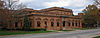 More images | |
| Holy Redeemer College | 925 Cousineau Road Windsor ON | 42°14′32″N 83°00′21″W / 42.2422°N 83.0059°W / 42.2422; -83.0059 (Holy Redeemer College) | Windsor municipality (11643) |  More images | |
| Imperial Building | 1900-1942 Wyandotte Street East Windsor ON | 42°19′23″N 83°00′47″W / 42.323°N 83.013°W / 42.323; -83.013 (Imperial Building) | Windsor municipality (5609) | Upload Photo | |
| Janisse-Schade House | 5325 Riverside Drive East Windsor ON | 42°19′50″N 82°58′27″W / 42.3306°N 82.9742°W / 42.3306; -82.9742 (Janisse-Schade House) | Windsor municipality (8519) | Upload Photo | |
| John Campbell School | 1255 Tecumseh Windsor ON | 42°18′00″N 83°00′23″W / 42.3°N 83.0064°W / 42.3; -83.0064 (John Campbell School) | Windsor municipality (14405) | Upload Photo | |
| Kathleen Henderson House | 1148 Victoria Avenue Windsor ON | 42°18′21″N 83°02′00″W / 42.3058°N 83.0334°W / 42.3058; -83.0334 (Kathleen Henderson House) | Windsor municipality (9043) | Upload Photo | |
| LaBelle Terrace | Corner of Chatham and Dougall Windsor ON | 42°19′02″N 83°02′34″W / 42.3172°N 83.0427°W / 42.3172; -83.0427 (LaBelle Terrace) | Windsor municipality (5619) | Upload Photo | |
| Mackenzie Hall (Former Essex County Court House) | 3277 Sandwich Street Windsor ON | 42°18′01″N 83°04′35″W / 42.3002°N 83.0763°W / 42.3002; -83.0763 (Mackenzie Hall (Former Essex County Court House)) | Windsor municipality (8520) | 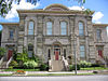 More images | |
| Mason-Girardot House | 3203 Peter Street Windsor ON | 42°18′05″N 83°04′26″W / 42.3013°N 83.074°W / 42.3013; -83.074 (Mason-Girardot House) | Windsor municipality (7708) | 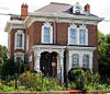 More images | |
| Masonic Hall | 986 Ouellette Avenue Windsor ON | 42°18′33″N 83°02′01″W / 42.3093°N 83.0337°W / 42.3093; -83.0337 (Masonic Hall) | Windsor municipality (8521) | Upload Photo | |
| Masson-Deck House | 3069 Alexander Avenue Windsor ON | 42°18′00″N 83°04′22″W / 42.2999°N 83.0727°W / 42.2999; -83.0727 (Masson-Deck House) | Windsor municipality (7579) | Upload Photo | |
| McGregor-Cowan House | 3118 Sandwich Street Windsor ON | 42°18′14″N 83°04′30″W / 42.3039°N 83.075°W / 42.3039; -83.075 (McGregor-Cowan House) | Windsor municipality (2240) | 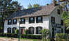 More images | |
| Medical Arts Building | 1011 Ouellette Avenue Windsor ON | 42°18′31″N 83°02′02″W / 42.3086°N 83.0338°W / 42.3086; -83.0338 (Medical Arts Building) | Windsor municipality (7984) | | |
| Mt. Zion Church of God in Christ | 795 McDougall Street Windsor ON | 42°18′48″N 83°01′53″W / 42.3132°N 83.0315°W / 42.3132; -83.0315 (Mt. Zion Church of God in Christ) | Windsor municipality (8522) | Upload Photo | |
| Patrice Parent House | 4371 Riverside Drive East Windsor ON | 42°19′38″N 82°59′04″W / 42.3271°N 82.9845°W / 42.3271; -82.9845 (Patrice Parent House) | Windsor municipality (8523) | Upload Photo | |
| Perry-Breault House | 245 Mill Street Windsor ON | 42°18′07″N 83°04′36″W / 42.302°N 83.0768°W / 42.302; -83.0768 (Perry-Breault House) | Windsor municipality (8524) | 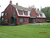 | |
| Porter-Coate House | 794 Devonshire Road Windsor ON | 42°19′17″N 83°00′38″W / 42.3214°N 83.0106°W / 42.3214; -83.0106 (Porter-Coate House) | Windsor municipality (5620) |  More images | |
| Revell-D'Avignon House | 567 Church Street Windsor ON | 42°18′47″N 83°02′29″W / 42.3131°N 83.0413°W / 42.3131; -83.0413 (Revell-D'Avignon House) | Windsor municipality (7986) | Upload Photo | |
| Robert Gordon House | 204 Curry Avenue Windsor ON | 42°18′50″N 83°03′26″W / 42.314°N 83.0572°W / 42.314; -83.0572 (Robert Gordon House) | Windsor municipality (3337) | Upload Photo | |
| Robinet Winery Building | 3200 Sandwich Street Windsor ON | 42°18′07″N 83°04′34″W / 42.302°N 83.076°W / 42.302; -83.076 (Robinet Winery Building) | Windsor municipality (7988) |  More images | |
| Robinson-Beaudet House | 908 Dawson Road Windsor ON | 42°19′29″N 82°58′36″W / 42.3246°N 82.9767°W / 42.3246; -82.9767 (Robinson-Beaudet House) | Windsor municipality (7769) | Upload Photo | |
| Roseland Golf Course | 455 Kennedy Drive West Windsor ON | 42°15′01″N 83°00′22″W / 42.2502°N 83.0062°W / 42.2502; -83.0062 (Roseland Golf Course) | Windsor municipality (5603) | Upload Photo | |
| St. John's Anglican Church and Cemetery | 3305 Sandwich Street Windsor ON | 42°17′57″N 83°04′36″W / 42.2993°N 83.0767°W / 42.2993; -83.0767 (St. John's Anglican Church and Cemetery) | Windsor municipality (8529) | 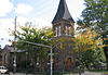 More images | |
| St. Peter's Maronite Church | 166 Tecumseh Road West Windsor ON | 42°17′48″N 83°01′37″W / 42.2966°N 83.027°W / 42.2966; -83.027 (St. Peter's Maronite Church) | Windsor municipality (8550) | Upload Photo | |
| St. Rose of Lima Church | 891 St. Rose Windsor ON | 42°19′47″N 82°57′12″W / 42.3298°N 82.9534°W / 42.3298; -82.9534 (St. Rose of Lima Church) | Windsor municipality (14581) | Upload Photo | |
| Sandwich First Baptist Church National Historic Site of Canada | 3652 Peter Street Windsor ON | 42°17′30″N 83°04′48″W / 42.2918°N 83.08°W / 42.2918; -83.08 (Sandwich First Baptist Church National Historic Site of Canada) | Federal (13374), Windsor municipality (8526) |  More images | |
| Sandwich Post Office | 3201 Sandwich Street Windsor ON | 42°18′06″N 83°04′31″W / 42.3018°N 83.0754°W / 42.3018; -83.0754 (Sandwich Post Office) | Windsor municipality (8527) | 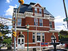 More images | |
| Stephen A. Griggs House | 889 Kildare Road Windsor ON | 42°19′10″N 83°00′40″W / 42.3194°N 83.0112°W / 42.3194; -83.0112 (Stephen A. Griggs House) | Windsor municipality (8551) | 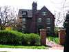 More images | |
| Taylor-Growe House | 742 Victoria Avenue Windsor ON | 42°18′42″N 83°02′14″W / 42.3118°N 83.0373°W / 42.3118; -83.0373 (Taylor-Growe House) | Windsor municipality (8553) | Upload Photo | |
| Treble-Large House | 719 Victoria Avenue Windsor ON | 42°18′43″N 83°02′18″W / 42.3119°N 83.0382°W / 42.3119; -83.0382 (Treble-Large House) | Windsor municipality (9234) | Upload Photo | |
| Wallmay Carriage House | 819 Argyle Road Windsor ON | 42°19′16″N 83°00′36″W / 42.3212°N 83.0099°W / 42.3212; -83.0099 (Wallmay Carriage House) | Windsor municipality (9551) | 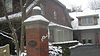 More images | |
| Wigle House | 3164 Sandwich Street Windsor ON | 42°18′11″N 83°04′32″W / 42.303°N 83.0756°W / 42.303; -83.0756 (Wigle House) | Windsor municipality (8558) | 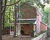 More images | |
| William Donald McGregor House | 916 Victoria Avenue Windsor ON | 42°18′35″N 83°02′10″W / 42.3098°N 83.036°W / 42.3098; -83.036 (William Donald McGregor House) | Windsor municipality (8562) | Upload Photo | |
| William T. Wesgate House | 225 Giles Boulevard West Windsor ON | 42°18′16″N 83°02′00″W / 42.3044°N 83.0333°W / 42.3044; -83.0333 (William T. Wesgate House) | Windsor municipality (3025) | Upload Photo | |
| Willistead Manor | 1899 Niagara Street Windsor ON | 42°19′03″N 83°00′36″W / 42.3176°N 83.01°W / 42.3176; -83.01 (Willistead Manor) | Windsor municipality (2274) | 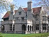 More images | |
| Windsor Armouries | 353 Freedom Way Windsor ON | 42°19′02″N 83°02′15″W / 42.3172°N 83.0376°W / 42.3172; -83.0376 (Windsor Armouries) | Windsor municipality (7707) | 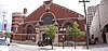 More images |
See also
Wikimedia Commons has media related to Cultural heritage monuments in Essex County, Ontario.
- List of historic places in Southwestern Ontario
- List of historic places in Ontario
- List of National Historic Sites of Canada in Ontario


