Lewis Chapel, Tennessee
Unincorporated community in Tennessee, United States
35°20′27″N 85°18′27″W / 35.34083°N 85.30750°W / 35.34083; -85.3075037327, 37338
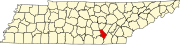
Lewis Chapel is an unincorporated community in Sequatchie County, Tennessee, United States.[1] It is located in the eastern part of the county atop the Waldens Ridge. Tennessee State Route 111 connects the community to Dunlap in the Sequatchie Valley to the west and Soddy-Daisy and the outskirts of Chattanooga in the Tennessee Valley to the east.
Lewis Chapel was probably named for the Reverend Edgar R. Lewis, an early minister in the area.[2]
References
- ^ a b c U.S. Geological Survey Geographic Names Information System: Lewis Chapel, Tennessee
- ^ Larry Miller, Tennessee Place Names (Indiana University Press, 2001), p. 122.
- v
- t
- e
Municipalities and communities of Sequatchie County, Tennessee, United States
County seat: Dunlap
communities
- Brush Creek
- Cagle
- Lewis Chapel
- Tennessee portal
- United States portal
 | This Sequatchie County, Tennessee geography–related article is a stub. You can help Wikipedia by expanding it. |
- v
- t
- e


