Laer
Municipality in North Rhine-Westphalia, Germany

Coat of arms
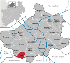
Location of Laer within Steinfurt district
(2022-12-31)[2]
48366
Laer (German pronunciation: [ˈlaːɐ̯]) is a municipality in the district of Steinfurt, in North Rhine-Westphalia, Germany. It is situated approximately 10 kilometres (6.2 mi) south of Steinfurt and 20 kilometres (12 mi) north-west of Münster.
Since the ae spelling already contradicted the rules in force before 1996, it was not amended in accordance with a recommendation of the Standing Committee on Geographical Names.[3]
Gallery
-
 Laer, chapel in the street
 -
 Holthausen, church (Pfarrkirche Sankt Marien)
 -
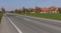 Altenburg, street view from local road


References
- ^ Wahlergebnisse in NRW Kommunalwahlen 2020, Land Nordrhein-Westfalen, accessed 30 June 2021.
- ^ "Bevölkerung der Gemeinden Nordrhein-Westfalens am 31. Dezember 2022 – Fortschreibung des Bevölkerungsstandes auf Basis des Zensus vom 9. Mai 2011" (in German). Landesbetrieb Information und Technik NRW. Retrieved 20 June 2023.
- ^ "StAGN Web - Homepage - Empfehlung zur Anwendung der Rechtschreibreform".
- v
- t
- e
Towns and municipalities in Steinfurt (district)
- Altenberge
- Emsdetten
- Greven
- Hopsten
- Hörstel
- Horstmar
- Ibbenbüren
- Ladbergen
- Laer
- Lengerich
- Lienen
- Lotte
- Metelen
- Mettingen
- Neuenkirchen
- Nordwalde
- Ochtrup
- Recke
- Rheine
- Saerbeck
- Steinfurt
- Tecklenburg
- Westerkappeln
- Wettringen

| Authority control databases: National |
|
|---|
| This Steinfurt district location article is a stub. You can help Wikipedia by expanding it. |
- v
- t
- e


