Lac La Ronge Provincial Park
Provincial park in Saskatchewan, Canada
55°16′17″N 104°43′56″W / 55.27139°N 104.73222°W / 55.27139; -104.73222
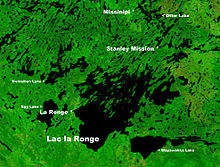
Lac La Ronge Provincial Park is located in the boreal forest of the north central part of the Canadian province of Saskatchewan within the Canadian Shield. Situated in the Churchill River system, this provincial park has close to 100 lakes and more than 30 canoe routes, many of which follow old fur trade routes. Summer activities include camping, hiking, boating, fishing, and swimming. In the winter, there's cross-country skiing, snowmobiling, and ice fishing.[1] Saskatchewan's highest waterfall is in the park. Nistowiak Falls are located north of Lac La Ronge along the Rapid River.
A little more than half of Lac La Ronge Provincial Park's area is water with Lac la Ronge being the largest lake. The park boundary begins on the western shore of Lac la Ronge at La Ronge and extends north to the Churchill River. Highway 102 forms this western boundary with one exception. About 13 kilometres (8.1 mi) north of the town of La Ronge, the park goes further west to include a section of Nemeiben Lake.[2] The northern section of the park follows the Churchill River until it goes south to include the eastern shore of Lac la Ronge. Just north of Wapawekka Lake on the eastern shore the park ends.[2][3]
Campgrounds
There are seven campgrounds throughout the park that offer a variety of different camping experiences. All campgrounds have fire pits, washrooms, and access to potable water.[4]
- Wadin Bay Campground (55°17′07″N 105°10′00″W / 55.2853°N 105.1666°W / 55.2853; -105.1666) is at Wadin Bay on Lac la Ronge along Highway 102. There is a mix of electric and non-electric sites and there is a sani-dump.[5]
- Churchill River Campground (55°38′41″N 104°44′08″W / 55.64483°N 104.7355°W / 55.64483; -104.7355) is located at Otter Rapids on the Churchill River. Campsites are on both sides of Highway 102. All sites are non-electric.[6]
- MacKay Lake Campground (55°27′17″N 104°52′21″W / 55.4548°N 104.8725°W / 55.4548; -104.8725) is a small campground in MacKay Lake. There's beach access, a fish cleaning station, and a boat launch. All campsites are non-electric.[7]
- Devil Lake Campground (55°39′35″N 104°43′45″W / 55.65974°N 104.7293°W / 55.65974; -104.7293) is a small campground at Devil Lake Recreation Site in Lac La Ronge Provincial Park along Highway 102. Besides the campsites, there's a boat launch, fish cleaning station, and a trail that goes from the campground to Churchill River bridge at Otter Rapids. All campsites are non-electric.[8]
- Nut Point Campground (55°07′44″N 105°15′42″W / 55.12889°N 105.2616°W / 55.12889; -105.2616) has both electric and non-electric campsites, a sani-dump, playground, and a 15-km walking trail.[9]
- Nemeiben Campground (55°15′38″N 105°22′18″W / 55.2605°N 105.3718°W / 55.2605; -105.3718) is a campground on Nemeiben Lake. There is a 1.5-km interpretive walking trail, fishing, and other recreational activities. There are a mix of electric and non-electric campsites and a sani-dump station.[10]
- Missinipe Campground (55°36′01″N 104°46′34″W / 55.6002°N 104.7761°W / 55.6002; -104.7761) is a 15-site campground on the west shore of Otter Lake, near Missinipe. All campsites are electric and there is a sani-dump station.[11]
Access
The town of La Ronge, 243 kilometres (151 mi) north of Prince Albert on the west side of Lac la Ronge, is reached by Highway 2. Highway 2 becomes Highway 102 within the community.
The following places in the park are reached from La Ronge on Highway 102 (distances are all from La Ronge).
- 18 kilometres (11 mi) north is the Nemeiben Lake access road.
- 27 kilometres (17 mi) north is Wadin Bay.
- 32 kilometres (20 mi) north is a settlement of the Lac La Ronge First Nation.
- 44 kilometres (27 mi) north is the junction of Highway 915 that leads to Stanley Mission. Across the Churchill River at Stanley Mission is Holy Trinity Anglican Church. Located in the Park it was designated a National Historic Site in 1970.[12]
- 79 kilometres (49 mi) north is Missinipe.
Highway 912 ends in a dead end in the eastern side of the park.
Flora and fauna
Wildlife found in and around the park include wolves, cougars, black bears[13] moose, deer, elk, antelope, caribou, coyotes, foxes, lynx, gophers, and rabbits. Trees commonly found in the park's rugged landscape are jack pine, spruce, and larch.[14]
Fish species found in the park's largest lake, Lac la Ronge, include walleye, sauger, yellow perch, northern pike, lake trout, lake whitefish, cisco, white sucker, longnose sucker, and burbot.[15]
See also
References
- ^ "Lac la Ronge Provincial Park | Tourism Saskatchewan".
- ^ a b "Natural Resources Canada-Canadian Geographical Names (Lac la Ronge)". Retrieved 29 August 2014.
- ^ "Provincial Parks". The Encyclopedia of Saskatchewan. University of Regina. Retrieved 20 September 2022.
- ^ "Lac la Ronge Provincial Park".
- ^ "Wadin Bay Campground | Tourism Saskatchewan".
- ^ "Churchill River Campground | Tourism Saskatchewan".
- ^ "MacKay Lake Campground | Tourism Saskatchewan".
- ^ "Devil Lake Campground | Tourism Saskatchewan".
- ^ "Nut Point Campground | Tourism Saskatchewan".
- ^ "Nemeiben Lake Campground | Tourism Saskatchewan".
- ^ "Missinipe Campground | Tourism Saskatchewan".
- ^ Holy Trinity Church National Historic Site of Canada. Canadian Register of Historic Places. Retrieved 17 August 2012.
- ^ "Conservation officers respond to black bears in Lac la Ronge Provincial Park".
- ^ "Saskatchewan - Plant and animal life | Britannica".
- ^ "Fish Species of Saskatchewan" (PDF). Saskatchewan Watershed Authority. Archived from the original (PDF) on 19 July 2011. Retrieved 13 October 2012.
External links
- AllTrails photos
![]() Media related to Lac La Ronge Provincial Park at Wikimedia Commons
Media related to Lac La Ronge Provincial Park at Wikimedia Commons
- v
- t
- e
- Athabasca Sand Dunes
- Battlefords, The
- Blackstrap
- Buffalo Pound
- Candle Lake
- Cannington Manor
- Clarence-Steepbank Lakes
- Clearwater River
- Crooked Lake
- Cumberland House
- Cypress Hills
- Danielson
- Douglas
- Duck Mountain
- Echo Valley
- Fort Carlton
- Fort Pitt
- Good Spirit Lake
- Great Blue Heron Provincial Park
- Greenwater Lake
- Katepwa Point
- Lac La Ronge
- Last Mountain House
- Makwa Lake
- Meadow Lake
- Moose Mountain
- Narrow Hills
- Pike Lake
- Porcupine Hills
- Rowan's Ravine
- Saskatchewan Landing
- St. Victor Petroglyphs
- Steele Narrows
- Touchwood Hills Post
- Wildcat Hill
- Wood Mountain Post
Canada in Saskatchewan
- Addison Sod House
- Batoche
- Battle of Cut Knife
- Battle of Duck Lake
- Battle of Fish Creek
- Battleford Court House
- Bell Farm
- Biggar railway station
- Canadian Bank of Commerce
- Claybank Brick Plant
- College Building
- Cumberland House
- Cypress Hills Massacre
- Doukhobor Dugout House
- Doukhobors at Veregin
- Esterhazy Flour Mill
- Forestry Farm Park and Zoo
- Former Prince Albert City Hall
- Fort de la Corne
- Fort Battleford
- Fort Carlton
- Fort Espérance
- Fort Livingstone
- Fort Pelly
- Fort Pitt
- Fort Qu'Appelle
- Fort Walsh
- Frenchman Butte
- Government House
- Gravelbourg Ecclesiastical Buildings
- Gray Burial Site
- Holy Trinity Church
- Humboldt Post Office
- Île-à-la-Crosse
- Keyhole Castle
- Last Mountain Lake Bird Sanctuary
- Moose Jaw Court House
- Motherwell Homestead
- Next of Kin Memorial Avenue
- Old Government House / Saint-Charles Scholasticate
- Prince Albert Arts Centre
- Saskatchewan Legislative Building and Grounds
- Saskatoon station (Canadian Pacific Railway)
- Seager Wheeler's Maple Grove Farm
- Steele Narrows
- Wanuskewin
- Carlton Trail Regional Park
- Cenotaph
- Fishing Lake Regional Park
- Palliser Regional Park
- Statue of Queen Elizabeth II riding Burmese
- Statue of Sir John A. Macdonald
- Victoria Park
- Wascana Centre
| Authority control databases: National |
|
|---|


