La Tour-du-Pin
Subprefecture of Isère, Auvergne-Rhône-Alpes, France
Subprefecture and commune in Auvergne-Rhône-Alpes, France
La Tour-du-Pin La Tor-du-Pin (Arpitan) | ||
|---|---|---|
Subprefecture and commune | ||
 Notre-Dame de l'Assomption in La Tour-du-Pin | ||
 Coat of arms | ||
Location of La Tour-du-Pin  | ||
(2023–2026) Claire Durand[1] | | |
| Area 1 | 4.77 km2 (1.84 sq mi) | |
| Population (2021)[2] | 8,138 | |
| • Density | 1,700/km2 (4,400/sq mi) | |
| Time zone | UTC+01:00 (CET) | |
| • Summer (DST) | UTC+02:00 (CEST) | |
| INSEE/Postal code | 38509 /38110 | |
| Elevation | 309–461 m (1,014–1,512 ft) (avg. 339 m or 1,112 ft) | |
| 1 French Land Register data, which excludes lakes, ponds, glaciers > 1 km2 (0.386 sq mi or 247 acres) and river estuaries. | ||
La Tour-du-Pin (French pronunciation: [la tuʁ dy pɛ̃] ⓘ; Arpitan: La Tor-du-Pin) is a subprefecture of the Isère department in the Auvergne-Rhône-Alpes region in Southeastern France.[3]
Geography
The Bourbre flows west through the southern part of the commune and crosses the town. The town's lowest point is at 309 m (1,014 ft) and the highest at 461 m (1,512 ft).
-
 Château de Tournin
 -
 La Tour-du-Pin station
 -
 Halles
 -
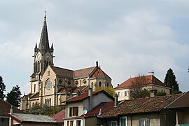
 General view
 -
 Subprefecture building


Population and society
|
| ||||||||||||||||||||||||||||||||||||||||||||||||||||||||||||||||||||||||||||||||||||||||||||||||||||||||||||||||||
| Source: EHESS[4] and INSEE (1968-2020)[5] | |||||||||||||||||||||||||||||||||||||||||||||||||||||||||||||||||||||||||||||||||||||||||||||||||||||||||||||||||||
Education
There are three public nursery and elementary schools (École Jean Rostand, École Albert Thevenon, and École Louis Pasteur) and one private nursery and primary school, the École St Joseph. There are also two public middle schools: the Collège Les Dauphins and the Collège Le Calloud, and one private middle school, the Collège St Bruno, there is one public high school too, the Lycée Élie Cartan, and one technical high school for learning of the horticulture.
Sport
There is a football club (FCTC), a rugby club (RCVT) and a basket-ball club (BVT).
See also
References
- ^ "Répertoire national des élus: les maires" (in French). data.gouv.fr, Plateforme ouverte des données publiques françaises. 6 June 2023.
- ^ "Populations légales 2021". The National Institute of Statistics and Economic Studies. 28 December 2023.
- ^ INSEE commune file
- ^ Des villages de Cassini aux communes d'aujourd'hui: Commune data sheet La Tour-du-Pin, EHESS (in French).
- ^ Population en historique depuis 1968, INSEE
Wikimedia Commons has media related to La Tour-du-Pin.
- v
- t
- e

- Les Abrets en Dauphiné
- Les Adrets
- Agnin
- L'Albenc
- Allemond
- Allevard
- Ambel
- Anjou
- Annoisin-Chatelans
- Anthon
- Aoste
- Apprieu
- Arandon-Passins
- Artas
- Assieu
- Auberives-en-Royans
- Auberives-sur-Varèze
- Auris
- Autrans-Méaudre-en-Vercors
- Les Avenières-Veyrins-Thuellin
- Avignonet
- La Balme-les-Grottes
- Barraux
- La Bâtie-Montgascon
- Beaucroissant
- Beaufin
- Beaufort
- Beaulieu
- Beaurepaire
- Beauvoir-de-Marc
- Beauvoir-en-Royans
- Bellegarde-Poussieu
- Belmont
- Bernin
- Besse
- Bessins
- Bévenais
- Bilieu
- Biol
- Biviers
- Bizonnes
- Blandin
- Bonnefamille
- Bossieu
- Le Bouchage
- Bougé-Chambalud
- Le Bourg-d'Oisans
- Bourgoin-Jallieu
- Bouvesse-Quirieu
- Brangues
- Bressieux
- Bresson
- Brézins
- Brié-et-Angonnes
- Brion
- La Buisse
- La Buissière
- Burcin
- Cessieu
- Châbons
- Chalon
- Chamagnieu
- Champagnier
- Champier
- Le Champ-près-Froges
- Champ-sur-Drac
- Chamrousse
- Chanas
- Chantepérier
- Chantesse
- Chapareillan
- La Chapelle-de-la-Tour
- La Chapelle-de-Surieu
- La Chapelle-du-Bard
- Charancieu
- Charantonnay
- Charavines
- Charette
- Charnècles
- Charvieu-Chavagneux
- Chasse-sur-Rhône
- Chasselay
- Chassignieu
- Château-Bernard
- Châteauvilain
- Châtel-en-Trièves
- Châtelus
- Châtenay
- Châtonnay
- Chatte
- Chavanoz
- Chélieu
- Chevrières
- Le Cheylas
- Cheyssieu
- Chèzeneuve
- Chichilianne
- Chimilin
- Chirens
- Cholonge
- Chonas-l'Amballan
- Choranche
- Chozeau
- Chuzelles
- Claix
- Clavans-en-Haut-Oisans
- Clelles
- Clonas-sur-Varèze
- Cognet
- Cognin-les-Gorges
- Colombe
- La Combe-de-Lancey
- Corbelin
- Corenc
- Cornillon-en-Trièves
- Corps
- Corrençon-en-Vercors
- La Côte-Saint-André
- Les Côtes-d'Arey
- Les Côtes-de-Corps
- Coublevie
- Cour-et-Buis
- Courtenay
- Crachier
- Cras
- Crémieu
- Crêts en Belledonne
- Creys-Mépieu
- Crolles
- Culin
- Les Deux Alpes
- Diémoz
- Dizimieu
- Doissin
- Dolomieu
- Domarin
- Domène
- Échirolles
- Eclose-Badinières
- Engins
- Entraigues
- Entre-deux-Guiers
- Les Éparres
- Estrablin
- Eybens
- Eydoche
- Eyzin-Pinet
- Faramans
- Faverges-de-la-Tour
- La Flachère
- Flachères
- Fontaine
- Fontanil-Cornillon
- La Forteresse
- Four
- Le Freney-d'Oisans
- La Frette
- Froges
- Frontonas
- La Garde
- Gières
- Gillonnay
- Goncelin
- Le Grand-Lemps
- Granieu
- Grenay
- Grenoblepref
- Gresse-en-Vercors
- Le Gua
- Le Haut-Bréda
- Herbeys
- Heyrieux
- Hières-sur-Amby
- Huez
- Hurtières
- L'Isle-d'Abeau
- Izeaux
- Izeron
- Janneyrias
- Jarcieu
- Jardin
- Jarrie
- Laffrey
- Lalley
- Lans-en-Vercors
- Lavaldens
- Laval-en-Belledonne
- Lavars
- Lentiol
- Leyrieu
- Lieudieu
- Livet-et-Gavet
- Longechenal
- Lumbin
- Luzinay
- Malleval-en-Vercors
- Marcieu
- Marcilloles
- Marcollin
- Marnans
- Massieu
- Maubec
- Mayres-Savel
- Mens
- Merlas
- Meylan
- Meyrié
- Meyrieu-les-Étangs
- Meyssiez
- Miribel-Lanchâtre
- Miribel-les-Échelles
- Mizoën
- Moidieu-Détourbe
- Moirans
- Moissieu-sur-Dolon
- Monestier-d'Ambel
- Monestier-de-Clermont
- Monestier-du-Percy
- Monsteroux-Milieu
- Montagne
- Montagnieu
- Montalieu-Vercieu
- Montaud
- Montbonnot-Saint-Martin
- Montcarra
- Montchaboud
- Monteynard
- Montfalcon
- Montferrat
- Montrevel
- Mont-Saint-Martin
- Montseveroux
- Moras
- Morestel
- Morette
- La Morte
- La Motte-d'Aveillans
- La Motte-Saint-Martin
- Mottier
- Le Moutaret
- La Mure
- La Murette
- Murianette
- Murinais
- Nantes-en-Ratier
- Nivolas-Vermelle
- Notre-Dame-de-Commiers
- Notre-Dame-de-l'Osier
- Notre-Dame-de-Mésage
- Notre-Dame-de-Vaulx
- Noyarey
- Optevoz
- Oris-en-Rattier
- Ornacieux-Balbins
- Ornon
- Oulles
- Oyeu
- Oytier-Saint-Oblas
- Oz
- Pact
- Pajay
- Panossas
- Parmilieu
- Le Passage
- Le Péage-de-Roussillon
- Pellafol
- Penol
- Le Percy
- La Pierre
- Pierre-Châtel
- Pisieu
- Plan
- Plateau-des-Petites-Roches
- Poisat
- Poliénas
- Pommier-de-Beaurepaire
- Ponsonnas
- Pontcharra
- Le Pont-de-Beauvoisin
- Pont-de-Chéruy
- Le Pont-de-Claix
- Pont-en-Royans
- Pont-Évêque
- Porcieu-Amblagnieu
- Porte-des-Bonnevaux
- Prébois
- Presles
- Pressins
- Primarette
- Proveysieux
- Prunières
- Quaix-en-Chartreuse
- Quet-en-Beaumont
- Quincieu
- Réaumont
- Renage
- Rencurel
- Revel
- Revel-Tourdan
- Reventin-Vaugris
- Rives
- La Rivière
- Roche
- Les Roches-de-Condrieu
- Rochetoirin
- Roissard
- Romagnieu
- Roussillon
- Rovon
- Royas
- Roybon
- Ruy-Montceau
- Sablons
- Saint-Agnin-sur-Bion
- Saint-Alban-de-Roche
- Saint-Alban-du-Rhône
- Saint-Albin-de-Vaulserre
- Saint-Andéol
- Saint-André-en-Royans
- Saint-André-le-Gaz
- Saint Antoine l'Abbaye
- Saint-Appolinard
- Saint-Arey
- Saint-Aupre
- Saint-Barthélemy
- Saint-Barthélemy-de-Séchilienne
- Saint-Baudille-de-la-Tour
- Saint-Baudille-et-Pipet
- Saint-Blaise-du-Buis
- Saint-Bonnet-de-Chavagne
- Saint-Bueil
- Saint-Cassien
- Saint-Chef
- Saint-Christophe-en-Oisans
- Saint-Christophe-sur-Guiers
- Saint-Clair-de-la-Tour
- Saint-Clair-du-Rhône
- Saint-Clair-sur-Galaure
- Saint-Didier-de-Bizonnes
- Saint-Didier-de-la-Tour
- Sainte-Agnès
- Sainte-Anne-sur-Gervonde
- Sainte-Blandine
- Saint-Égrève
- Sainte-Luce
- Sainte-Marie-d'Alloix
- Sainte-Marie-du-Mont
- Saint-Étienne-de-Crossey
- Saint-Étienne-de-Saint-Geoirs
- Saint-Geoire-en-Valdaine
- Saint-Geoirs
- Saint-Georges-de-Commiers
- Saint-Georges-d'Espéranche
- Saint-Gervais
- Saint-Guillaume
- Saint-Hilaire-de-Brens
- Saint-Hilaire-de-la-Côte
- Saint-Hilaire-du-Rosier
- Saint-Honoré
- Saint-Ismier
- Saint-Jean-d'Avelanne
- Saint-Jean-de-Bournay
- Saint-Jean-de-Moirans
- Saint-Jean-de-Soudain
- Saint-Jean-de-Vaulx
- Saint-Jean-d'Hérans
- Saint-Jean-le-Vieux
- Saint-Joseph-de-Rivière
- Saint-Julien-de-l'Herms
- Saint-Just-Chaleyssin
- Saint-Just-de-Claix
- Saint-Lattier
- Saint-Laurent-du-Pont
- Saint-Laurent-en-Beaumont
- Saint-Marcel-Bel-Accueil
- Saint-Marcellin
- Saint-Martin-de-Clelles
- Saint-Martin-de-la-Cluze
- Saint-Martin-de-Vaulserre
- Saint-Martin-d'Hères
- Saint-Martin-d'Uriage
- Saint-Martin-le-Vinoux
- Saint-Maurice-en-Trièves
- Saint-Maurice-l'Exil
- Saint-Maximin
- Saint-Michel-de-Saint-Geoirs
- Saint-Michel-en-Beaumont
- Saint-Michel-les-Portes
- Saint-Mury-Monteymond
- Saint-Nazaire-les-Eymes
- Saint-Nicolas-de-Macherin
- Saint-Nizier-du-Moucherotte
- Saint-Ondras
- Saint-Paul-de-Varces
- Saint-Paul-d'Izeaux
- Saint-Paul-lès-Monestier
- Saint-Pierre-de-Bressieux
- Saint-Pierre-de-Chartreuse
- Saint-Pierre-de-Chérennes
- Saint-Pierre-de-Méaroz
- Saint-Pierre-de-Mésage
- Saint-Pierre-d'Entremont
- Saint-Prim
- Saint-Quentin-Fallavier
- Saint-Quentin-sur-Isère
- Saint-Romain-de-Jalionas
- Saint-Romain-de-Surieu
- Saint-Romans
- Saint-Sauveur
- Saint-Savin
- Saint-Siméon-de-Bressieux
- Saint-Sorlin-de-Morestel
- Saint-Sorlin-de-Vienne
- Saint-Sulpice-des-Rivoires
- Saint-Théoffrey
- Saint-Vérand
- Saint-Victor-de-Cessieu
- Saint-Victor-de-Morestel
- Saint-Vincent-de-Mercuze
- Salagnon
- Salaise-sur-Sanne
- La Salette-Fallavaux
- La Salle-en-Beaumont
- Le Sappey-en-Chartreuse
- Sarcenas
- Sardieu
- Sassenage
- Satolas-et-Bonce
- Savas-Mépin
- Séchilienne
- Septème
- Sérézin-de-la-Tour
- Sermérieu
- Serpaize
- Serre-Nerpol
- Seyssinet-Pariset
- Seyssins
- Seyssuel
- Siccieu-Saint-Julien-et-Carisieu
- Siévoz
- Sillans
- Sinard
- Soleymieu
- La Sône
- Sonnay
- Sousville
- Succieu
- La Sure en Chartreuse
- Susville
- Têche
- Tencin
- La Terrasse
- Theys
- Thodure
- Tignieu-Jameyzieu
- Torchefelon
- La Tour-du-Pinsubpr
- Le Touvet
- Tramolé
- Treffort
- Tréminis
- Trept
- La Tronche
- Tullins
- Valbonnais
- Val-de-Virieu
- Valencin
- Valencogne
- La Valette
- Valjouffrey
- Varacieux
- Varces-Allières-et-Risset
- Vasselin
- Vatilieu
- Vaujany
- Vaulnaveys-le-Bas
- Vaulnaveys-le-Haut
- Vaulx-Milieu
- Velanne
- Vénérieu
- Venon
- Vernas
- Vernioz
- La Verpillière
- Le Versoud
- Vertrieu
- Veurey-Voroize
- Veyssilieu
- Vézeronce-Curtin
- Viennesubpr
- Vif
- Vignieu
- Villages du Lac de Paladru
- Villard-Bonnot
- Villard-de-Lans
- Villard-Notre-Dame
- Villard-Reculas
- Villard-Reymond
- Villard-Saint-Christophe
- Villefontaine
- Villemoirieu
- Villeneuve-de-Marc
- Ville-sous-Anjou
- Villette-d'Anthon
- Villette-de-Vienne
- Vinay
- Viriville
- Vizille
- Voiron
- Voissant
- Voreppe
- Vourey
- pref: prefecture
- subpr: subprefecture
Authority control databases | |
|---|---|
| International |
|
| National |
|
| Geographic |
|


