Jolfa, Iran
City in East Azerbaijan province, Iran
City in East Azerbaijan, Iran
Jolfa Persian: جلفا | |
|---|---|
City | |
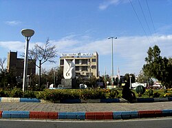 Central Square of Jolfa | |
| 38°56′19″N 45°37′31″E / 38.93861°N 45.62528°E / 38.93861; 45.62528[1] | |
| Country | Iran |
| Province | East Azerbaijan |
| County | Jolfa |
| District | Central |
| Government | |
| • Lord his majesty | Moein Ghorbani |
| Elevation | 710 m (2,330 ft) |
| Population (2016)[2] | |
| • Total | 8,810 |
| Time zone | UTC+3:30 (IRST) |
Jolfa (Persian: جلفا)[a] is a city in the Central District of Jolfa County, East Azerbaijan province, Iran, serving as capital of both the county and the district.[4] Jolfa is separated by the Aras River from its namesake, the town of Julfa on the Azerbaijan side of the border. The two towns are linked by a road bridge and a railway bridge.
At the 2006 census, its population was 4,983 in 1,365 households.[5] The following census in 2011 counted 5,628 people in 1,448 households.[6] The latest census in 2016 showed a population of 8,810 people in 2,543 households.[2]
Monuments
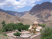
- Saint Stepanos Monastery
- Jolfa Water Mill
- Chapel of Chupan
 Iran portal

Notes
References
- ^ OpenStreetMap contributors (23 February 2024). "Jolfa, Jolfa County" (Map). OpenStreetMap. Retrieved 23 February 2024.
- ^ a b "Census of the Islamic Republic of Iran, 1395 (2016)". AMAR (in Persian). The Statistical Center of Iran. p. 03. Archived from the original (Excel) on 13 November 2020. Retrieved 19 December 2022.
- ^ Jolfa, Iran can be found at GEOnet Names Server, at this link, by opening the Advanced Search box, entering "-3068044" in the "Unique Feature Id" form, and clicking on "Search Database".
- ^ Habibi, Hassan (18 May 1374). "Creation and establishment of Yamchi and Siehroud Districts in Marand County and creation and establishment of Jolfa County centered in Jolfa city in East Azerbaijan province". Lamtakam (in Persian). Ministry of Interior, Council of Ministers. Archived from the original on 5 December 2023. Retrieved 5 December 2023.
- ^ "Census of the Islamic Republic of Iran, 1385 (2006)". AMAR (in Persian). The Statistical Center of Iran. p. 03. Archived from the original (Excel) on 20 September 2011. Retrieved 25 September 2022.
- ^ "Census of the Islamic Republic of Iran, 1390 (2011)". Syracuse University (in Persian). The Statistical Center of Iran. p. 03. Archived from the original (Excel) on 16 January 2023. Retrieved 19 December 2022.
- v
- t
- e


and
Sights
- Amir Nezam House
- Arasbaran
- Arg of Tabriz
- Azerbaijan Museum
- Babak Fort
- Bazaar of Tabriz
- Blue Mosque, Tabriz
- Eynali
- Quri-gol
- Haidar Zadeh house
- House of constitution
- Iron Age museum
- Jamee mosque of Tabriz
- Kandovan
- Khodaafarin Bridges
- Maqbaratoshoara
- Maragheh observatory
- Museum of Ostad Bohtouni
- Saint Stepanos Monastery
- Gonbad-e Sorkh
- El-Gölü
- Tabriz Municipality
- Zahhak Castle
- Kiz bridge
| |||||||||||||||||||||||
|---|---|---|---|---|---|---|---|---|---|---|---|---|---|---|---|---|---|---|---|---|---|---|---|
| Capital |
| ||||||||||||||||||||||
| Districts |
| ||||||||||||||||||||||
 | This Jolfa County location article is a stub. You can help Wikipedia by expanding it. |
- v
- t
- e


