Harmannsdorf
Place in Lower Austria, Austria

Coat of arms
(2018-01-01)[2]
2111 / 2112
Harmannsdorf is a municipality of Korneuburg in Austria.
Geography
It lies about 5 km north of Korneuburg in the Weinviertel in Lower Austria. About 27.59 percent of the municipality is forested.
It has seven subdivisions: Rückersdorf-Harmannsdorf, Hetzmannsdorf, Kleinrötz, Mollmannsdorf, Obergänserndorf, Seebarn, and Würnitz-Lerchenau;
Gallery
-
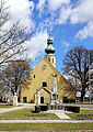 Parish church of Rückersdorf
 -
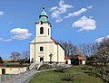 Parish church of Obergänserndorf
 -
 Branch church of Kleinrötz
 -
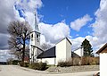 Parish church of Würnitz


References
External links
- Harmannsdorf Homepage
- v
- t
- e
Municipalities in the district of Korneuburg
- Bisamberg
- Enzersfeld im Weinviertel
- Ernstbrunn
- Gerasdorf bei Wien
- Großmugl
- Großrußbach
- Hagenbrunn
- Harmannsdorf
- Hausleiten
- Korneuburg
- Langenzersdorf
- Leitzersdorf
- Leobendorf
- Niederhollabrunn
- Rußbach
- Sierndorf
- Spillern
- Stetteldorf am Wagram
- Stetten
- Stockerau
Authority control databases | |
|---|---|
| International |
|
| National |
|
| Geographic |
|
 | This Lower Austria location article is a stub. You can help Wikipedia by expanding it. |
- v
- t
- e


