Hàm Thuận Nam district
You can help expand this article with text translated from the corresponding article in Vietnamese. (March 2009) Click [show] for important translation instructions.
- View a machine-translated version of the Vietnamese article.
- Machine translation, like DeepL or Google Translate, is a useful starting point for translations, but translators must revise errors as necessary and confirm that the translation is accurate, rather than simply copy-pasting machine-translated text into the English Wikipedia.
- Consider adding a topic to this template: there are already 952 articles in the main category, and specifying
|topic=will aid in categorization. - Do not translate text that appears unreliable or low-quality. If possible, verify the text with references provided in the foreign-language article.
- You must provide copyright attribution in the edit summary accompanying your translation by providing an interlanguage link to the source of your translation. A model attribution edit summary is
Content in this edit is translated from the existing Vietnamese Wikipedia article at [[:vi:Hàm Thuận Nam]]; see its history for attribution. - You may also add the template
{{Translated|vi|Hàm Thuận Nam}}to the talk page. - For more guidance, see Wikipedia:Translation.
District in Southeast, Vietnam
Hàm Thuận Nam district Huyện Hàm Thuận Nam | |
|---|---|
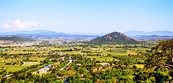 View from above of the Hàm Thuận Nam landscape | |
| Country |  Vietnam Vietnam |
| Region | Southeast |
| Province | Bình Thuận |
| Capital | Thuận Nam |
| Area | |
| • District | 406 sq mi (1,052 km2) |
| Population (2019) | |
| • District | 116,544 |
| • Density | 290/sq mi (110/km2) |
| • Urban | 14,697 |
| • Rural | 101,847 |
| Time zone | UTC+07:00 (Indochina Time) |
Hàm Thuận Nam is a rural district of Bình Thuận province in the Southeast region of Vietnam.
As of 2019, the district had a population of 116,544.[1][2] The district covers an area of 1,052 km². The district capital lies at Thuận Nam.[2][3]
References
11°00′00″N 107°55′01″E / 11.000°N 107.917°E / 11.000; 107.917
- v
- t
- e
Districts of the Vietnamese South Central Coast

- Phan Thiết city※
- La Gi town
- Bắc Bình
- Đức Linh
- Hàm Tân
- Hàm Thuận Bắc
- Hàm Thuận Nam
- Phú Quý Island
- Tánh Linh
- Tuy Phong
- Cam Ranh city
- Nha Trang city※
- Ninh Hòa town
- Cam Lâm
- Diên Khánh
- Khánh Sơn
- Khánh Vĩnh
- Trường Sa§
- Vạn Ninh
※ denotes provincial seat. / § Sovereignty over the Hoàng Sa and Trường Sa archipelagoes is disputed as of 16 May 2024.
Authority control databases | |
|---|---|
| International |
|
| National |
|
 | This article about a location in Bình Thuận Province, Vietnam is a stub. You can help Wikipedia by expanding it. |
- v
- t
- e


