Grade II* listed buildings in the London Borough of Waltham Forest
Map all coordinates using OpenStreetMap
Download coordinates as:
- KML
- GPX (all coordinates)
- GPX (primary coordinates)
- GPX (secondary coordinates)
There are over 20,000 Grade II* listed buildings in England. This page is a list of these buildings in the London Borough of Waltham Forest.
Buildings
| Name | Location | Type | Completed [note 1] | Date designated | Grid ref.[note 2] Geo-coordinates | Entry number [note 3] | Image |
|---|---|---|---|---|---|---|---|
| Walthamstow Granada | Walthamstow | Cinema, Public House | Late C20 | 24 February 1987 | TQ3724389311 51°35′09″N 0°01′14″W / 51.585949°N 0.020434°W / 51.585949; -0.020434 (Walthamstow Granada) | 1065590 | 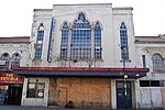 More images |
| Chestnuts House | Walthamstow | House | 1745-7 | 19 October 1951 | TQ3747988447 51°34′41″N 0°01′03″W / 51.578127°N 0.017368°W / 51.578127; -0.017368 (Chestnuts House) | 1191062 | 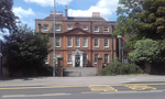 |
| Church of All Saints | Chingford | Parish Church | 12th century | 28 June 1954 | TQ3737293382 51°37′21″N 0°01′01″W / 51.622499°N 0.01698°W / 51.622499; -0.01698 (Church of All Saints) | 1065596 |  More images |
| Church of St Barnabas and St James the Greater | Walthamstow | Church | 1903 | 24 February 1981 | TQ3722488298 51°34′37″N 0°01′16″W / 51.576851°N 0.021103°W / 51.576851; -0.021103 (Church of St Barnabas and St James the Greater) | 1065600 |  More images |
| Church of St Peter and St Paul | Chingford | Church | 1844 | 28 June 1954 | TQ3860494383 51°37′52″N 0°00′04″E / 51.631192°N 0.001201°E / 51.631192; 0.001201 (Church of St Peter and St Paul) | 1065582 |  More images |
| St Mary's Church, Leyton | Leyton | Parish Church | 1658 | 27 May 1954 | TQ3768186857 51°33′50″N 0°00′54″W / 51.563791°N 0.015077°W / 51.563791; -0.015077 (St Mary's Church, Leyton) | 1293623 | 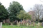 More images |
| Parish Church of St Mary's | Walthamstow | Church | 16th century | 19 October 1951 | TQ3784289229 51°35′06″N 0°00′43″W / 51.585066°N 0.011826°W / 51.585066; -0.011826 (Parish Church of St Mary's) | 1357600 |  More images |
| Leytonstone Library | Leytonstone | Library | 1934 | 28 April 2014 | TQ3943387392 51°34′05″N 0°00′37″E / 51.568168°N 0.010395°E / 51.568168; 0.010395 (Leytonstone Library) | 1418380 | 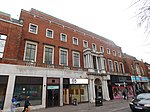 More images |
| Queen Elizabeth's Hunting Lodge | Chingford | Hunting Lodge | Early 16th century | 28 June 1954 | TQ3972494776 51°38′04″N 0°01′03″E / 51.634447°N 0.017529°E / 51.634447; 0.017529 (Queen Elizabeth's Hunting Lodge) | 1293481 |  More images |
| The United Free Church | Woodford Green | Church | 1904 | 24 February 1987 | TQ4001692188 51°36′40″N 0°01′15″E / 51.611119°N 0.020712°E / 51.611119; 0.020712 (The United Free Church) | 1081029 |  More images |
| The Water House, Lloyd Park (William Morris Gallery) | Walthamstow | House | 1762 | 19 October 1951 | TQ3722989902 51°35′29″N 0°01′13″W / 51.591263°N 0.020405°W / 51.591263; -0.020405 (The Water House, Lloyd Park (William Morris Gallery)) | 1065620 |  More images |
| Walnut Tree House | Leyton | House | Mid 16th century or earlier | 27 May 1954 | TQ3802787126 51°33′58″N 0°00′36″W / 51.566123°N 0.009983°W / 51.566123; -0.009983 (Walnut Tree House) | 1065586 |  More images |
| Walthamstow House (Corpus Christi School) | Walthamstow | House | Mid-18th century | 19 October 1951 | TQ3810189745 51°35′23″N 0°00′28″W / 51.589639°N 0.007887°W / 51.589639; -0.007887 (Walthamstow House (Corpus Christi School)) | 1065601 |  More images |
See also
Notes
- ^ The date given is the date used by Historic England as significant for the initial building or that of an important part in the structure's description.
- ^ Sometimes known as OSGB36, the grid reference is based on the British national grid reference system used by the Ordnance Survey.
- ^ The "List Entry Number" is a unique number assigned to each listed building and scheduled monument by Historic England.
External links
 Media related to Grade II* listed buildings in the London Borough of Waltham Forest at Wikimedia Commons
- v
- t
- e
- Cann Hall
- Chingford (including Chingford Green, Chingford Hatch, Chingford Mount and South Chingford, Friday Hill)
- Highams Park (including Hale End)
- Leyton (including Bakers Arms and Lea Bridge)
- Leytonstone (including Whipps Cross)
- Temple Mills
- Walthamstow (including Walthamstow Village and Upper Walthamstow)
- Woodford (Woodford Green)


- Brisbane Road football stadium
- Epping Forest
- Lee Valley Riding Centre
- Lee Valley Ice Centre
- New Spitalfields Market
- Queen Elizabeth's Hunting Lodge
- Vestry House Museum
- Waltham Forest Theatre
- Walthamstow Pump House Museum
- Walthamstow Stadium
- William Morris Gallery
- Larkswood Playing Fields
- Lee Valley Park
- WaterWorks Nature Reserve
- Walthamstow Marshes
- Chingford and Woodford Green (part)
- Leyton and Wanstead (part)
- Walthamstow

- Council
- Listed buildings
- Grade II*
- Grade II
- People
- Public art
- Schools
 Category
- Commons

Portals:
 London
 Architecture


