Doña Juana
Active volcano in Colombia

Doña Juana
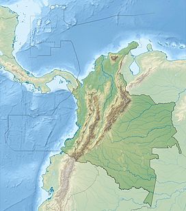
Location of Doña Juana in Colombia
 Colombia
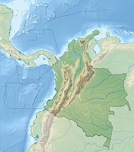
Andes

Nevado del Huila
Nevado del Ruiz
Nevado del Tolima
Puracé
Doña Juana
Galeras
class=notpageimage|
Major volcanoes in ColombiaDoña Juana (Spanish: Volcán Doña Juana[1]) is a stratovolcano,[2] located within the Doña Juana-Cascabel Volcanic Complex National Natural Park (Spanish: Parque Nacional Natural Complejo Volcánico Doña Juana-Cascabel) in Nariño, Colombia.
With a previous eruption of VEI 4, Doña Juana is rated as a "large" volcano of "cataclysmic" destructive power.[3] During its last eruption, in 1906,[2] more than 100 people were killed and many houses were destroyed.
Its largest known historical eruption was on November 13, 1899. In its prehistory, it is known to have erupted in the 23rd century BC in a caldera-forming eruption of unknown magnitude.[3]
Etymology
The name of the volcano originated from a legend of the Chincha Indians, within whose native lands it is located: Mama Juana, a beautiful Quiteña, fell in love with Pedro, a commoner, but with the parents opposed to the marriage, they fled, becoming the victims of a curse that turned them into volcanoes.[4]
Biodiversity
The volcano can be ascended from a slope that is part of the so-called Valley of Orchids. It is surrounded by an area of extraordinary biodiversity, which includes 471 species of birds (the Andean condor included), bears, deer and pumas.[4]
The summit of Dona Juana consists of a number of peaks, which afford a number of views, including of Laguna del Silencio, one of 42 lakes in the national park.[4] The Petacas is located to the northeast of Doña Juana. Both volcanoes are located between the El Tablón Fault in the west and the San Jerónimo Fault in the east.[5]
Gallery
-
 2007
2007

See also
References
Wikimedia Commons has media related to Doña Juana (volcano).
- ^ "Volcán Doña Juana: Colombia". Geographical Names. Retrieved 2011-01-11.
- ^ a b "Doña Juana". Global Volcanism Program. Smithsonian Institution.
- ^ a b "Large Volcano Explocivity Index". Countries of the World. Retrieved 2011-01-13.
- ^ a b c "De visita por el complejo volcánico de Doña Juana y Cascabel". El Tiempo. Retrieved 2011-01-13.
- ^ Plancha 411, 2002
Bibliography
- Núñez, Alberto, and Jorge Gómez. 2002. Plancha 411 - La Cruz - 1:100,000, 1. INGEOMINAS. Accessed 2017-06-06.
- v
- t
- e
(6° N – 3° S)
- Paipa-Iza
- Romeral
- Cerro Bravo
- Nevado del Ruiz
- Nevado del Tolima
- Nevado del Huila
- Puracé
- Doña Juana
- Galeras
- Azufral
- Chiles
- Cayambe
- Reventador
- Pichincha
- Antisana
- Aliso
- Soche
- Illiniza
- Cotopaxi
- Quilotoa
- Chimborazo
- Tungurahua
- Licto volcanic field
- Sangay
(14°–27° S)
- Quimsachata
- Auquihuato
- Firura
- Sara Sara
- Solimana
- Coropuna
- Hualca Hualca
- Sabancaya
- Huambo volcanic field
- Ampato
- Andagua volcanic field
- Chachani
- Misti
- Ubinas
- Pichu Pichu
- Huaynaputina
- Ticsani
- Tutupaca
- Yucamane
- Purupuruni
- Casiri
- Tacora
- Taapaca
- Parinacota
- Lauca
- Guallatiri
- Tata Sabaya
- Isluga
- Irruputuncu
- Olca-Paruma
- Aucanquilcha
- Azufre
- Zapaleri
- Sairecabur
- Licancabur
- Purico complex
- Pacana
- Aguas Calientes
- Lascar
- Chiliques
- Aracar
- Socompa
- Llullaillaco
- Lastarria
- Lazufre
- Cordón del Azufre
- Galán
- Peinado
- San Francisco
- Cueros de Purulla
- Incahuasi
- Ojos del Salado
(33°–46° S)
- Tupungato
- Tupungatito
- Maipo
- Calabozos
- Descabezado Grande
- Cerro Azul
- Nevado de Longaví
- Nevados de Chillán
- Antuco
- Copahue
- Callaqui
- Lonquimay
- Llaima
- Sollipulli
- Villarrica
- Quetrupillán
- Lanín
- Mocho-Choshuenco
- Carrán-Los Venados
- Puyehue-Cordón Caulle
- Casablanca
- Osorno
- Calbuco
- Hornopirén
- Huequi
- Michinmahuida
- Chaitén
- Corcovado
- Mentolat
- Cay
- Macá
- Mate Grande
- Hudson
(49°–55° S)
Note: volcanoes are ordered by latitude from north to south
| ||
|---|---|---|
| Western Ranges |    | |
| Central Ranges |
| |
| Eastern Ranges | ||
| Other | ||
| Source |
| |
 Category • Images Category • Images  | ||


