Denekamp
Town in Overijssel, Netherlands

Flag

Coat of arms
Köttelpeern

The town centre (dark green) and the statistical district (light green) of Denekamp in the municipality of Dinkelland.
52°22′46″N 7°0′32″E / 52.37944°N 7.00889°E / 52.37944; 7.00889
(2021)[1]
7591[1]
Denekamp (Dutch pronunciation: [ˈdeːnəkɑmp] ⓘ) is a town in the Dutch province of Overijssel. It is a part of the region of Twente and the municipality of Dinkelland, and lies about 9 km northeast of Oldenzaal.
The town was first noted as early as the 10th century when it was referred to as Daginghem, and means "settlement of the people of Dago or Dano".[3] The village started around the church which was built in 1275. It remained isolated and small until 1829 when the road from Deventer to Hamburg was built.[4]
The location became a municipality in 1818 incorporating the settlements of Noord Deurningen, Lattrop, Breklenkamp, Tilligte, Nutter and Agelo. The municipality merged with Ootmarsum and Weerselo in 2001; the new municipality was first called "Denekamp", but was renamed in 2002 to Dinkelland.[5]
The Town is known in the hardstyle scene, to be home of various Hardstyle DJ's.
Notable people from Denekamp
- Roméo Dallaire (1946-), Canadian senator and retired general.
- Hennie Kuiper (1949-), world champion cyclist.
- Tanja Nijmeijer, FARC member.
- Radical Redemption, Hardstyle producer and DJ.
- Angerfist, Hardstyle producer and DJ.
Gallery
-
 Windmill: de Sint Nicolaasmolen
 -
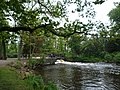 Brook
Brook -
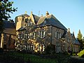 Clergy house
 -
 St. Nicholas Church in Denekamp


References
- ^ a b c "Kerncijfers wijken en buurten 2021". Central Bureau of Statistics. Retrieved 15 March 2022.
- ^ "Postcodetool for 7591AA". Actueel Hoogtebestand Nederland (in Dutch). Het Waterschapshuis. Retrieved 15 March 2022.
- ^ "Denekamp - (geografische naam)". Etymologiebank (in Dutch). Retrieved 15 March 2022.
- ^ Ronald Stenvert & Jan ten Hove (1998). "Denekamp" (in Dutch). Zwolle: Waanders. p. 93. ISBN 90 400 9200 1. Retrieved 15 March 2022.
- ^ Ad van der Meer and Onno Boonstra, Repertorium van Nederlandse gemeenten, KNAW, 2011.
Wikimedia Commons has media related to Denekamp.
Authority control databases | |
|---|---|
| International |
|
| National |
|
| Geographic |
|
 | This Overijssel location article is a stub. You can help Wikipedia by expanding it. |
- v
- t
- e


