Clough
Village in County Down, Northern Ireland
54°17′20″N 5°50′06″W / 54.289°N 5.835°W / 54.289; -5.835

Clough (/ˈklɒx/ KLOKH;[1] from Irish an Chloch, meaning 'the stone') is a village and townland in County Down, Northern Ireland. It sits about 3 miles from Dundrum on the A2 between Newcastle and Belfast. The A2 continues via Downpatrick and the coast via Strangford and the Portaferry – Strangford Ferry to Portaferry to Belfast, whilst most road traffic heads along from Clough along the A24 via Carryduff to Belfast. It had a population of 255 people in the 2001 census. Clough is situated within the Newry, Mourne and Down area.
Places of interest
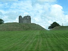
- Clough Castle, an excellent example of an Anglo-Norman motte-and-bailey castle with stone tower.
Etymology
A map of 1634 marked the village as Machaeracate and the castle is Cloch Mhachaire Cat "Stone castle of the plain of the cat". This comes from a local legend of the chase of magic cat.[2]
References
External links
- NI Neighbourhood Information Service
- Culture Northern Ireland
Wikimedia Commons has media related to Clough, County Down.
- v
- t
- e
Places in County Down

and townlands
- Annahilt
- Annalong
- Annsborough
- Ardglass
- Attical
- Aughnacloy
- Ballela
- Balloo
- Ballybannan
- Ballydargan
- Ballygowan
- Ballyhalbert
- Ballyhay
- Ballyholme
- Ballyhornan
- Ballykinler
- Ballylesson
- Ballylough
- Ballymacmaine
- Ballymartin
- Ballynagarrick
- Ballynahatty
- Ballynoe
- Ballyskeagh
- Ballywalter
- Benraw
- Blackskull
- Bleary
- Braniel
- Bryansford
- Burren
- Cabra
- Carnalea
- Carrowdore
- Castlewellan
- Clandeboye
- Cloghy
- Clough
- Conlig
- Corbet
- Crawfordsburn
- Cregagh
- Crossgar
- Cultra
- Derryneill
- Dollingstown
- Donaghcloney
- Dromara
- Drumaness
- Drumbeg
- Drumbo
- Drumlough, Hillsborough
- Drumlough, Rathfriland
- Dundrum
- Dunnaval
- Edenderry
- Gamblestown
- Gilford
- Gilnahirk
- Gransha
- Greencastle
- Greyabbey
- Groomsport
- Helen's Bay
- Hillhall
- Hillsborough
- Hilltown
- Katesbridge
- Kilcoo
- Kilcooley
- Killinchy
- Killinure
- Killough
- Killowen
- Killyleagh
- Kinallen
- Kircubbin
- Lawrencetown
- Legacurry
- Legananny
- Leitrim
- Lenaderg
- Loughbrickland
- Loughinisland
- Lurganare
- Lurganville
- Magheraconluce
- Magheralin
- Mayobridge
- Maze
- Millisle
- Moira
- Moneyreagh
- Moneyslane
- Monteith
- Newtownbreda
- Portaferry
- Portavogie
- Poyntzpass
- Rathfriland
- Ravernet
- Ringhaddy
- Rostrevor
- Saintfield
- Saul
- Scarva
- Seaforde
- Seahill
- Sheeptown
- Shrigley
- Spa
- Strangford
- Struell
- Tievenadarragh
- Tullylish
- Tullynakill
- Waringsford
- Waringstown
- Whiterock
- WikiProject Northern Ireland
- WikiProject Ireland
- Northern Ireland Portal
- United Kingdom Portal
- Ireland Portal
| Authority control databases: National |
|
|---|
 | This article related to the geography of County Down, Northern Ireland is a stub. You can help Wikipedia by expanding it. |
- v
- t
- e


