Chiaravalle, Marche
Comune in Marche, Italy
Location of Chiaravalle

43°36′N 13°20′E / 43.600°N 13.333°E / 43.600; 13.333
(Dec. 2004)[2]
60033
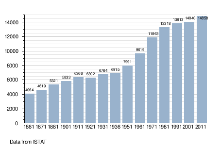
Chiaravalle is a comune (municipality) in the Province of Ancona in the Italian region Marche, located about 15 kilometres (9 mi) west of Ancona. As of 31 December 2004, it had a population of 14,397 and an area of 17.4 square kilometres (6.7 sq mi).[3]
The municipality of Chiaravalle contains the frazione (subdivision) Grancetta.
Chiaravalle borders the following municipalities: Camerata Picena, Falconara Marittima, Jesi, Monte San Vito, Montemarciano.
Demographic evolution
Notable people
- Clio Maria Bittoni, Italian jurist and former First Lady of Italy
- Maria Montessori, Italian physician and educator
- Sofia Raffaeli, Italian rhythmic gymnast
References
- ^ "Superficie di Comuni Province e Regioni italiane al 9 ottobre 2011". Italian National Institute of Statistics. Retrieved 16 March 2019.
- ^ "Popolazione Residente al 1° Gennaio 2018". Italian National Institute of Statistics. Retrieved 16 March 2019.
- ^ All demographics and other statistics: Italian statistical institute Istat.
External links
- www.comune.chiaravalle.an.it
- v
- t
- e
- Agugliano
- Ancona
- Arcevia
- Barbara
- Belvedere Ostrense
- Camerano
- Camerata Picena
- Castel Colonna
- Castelbellino
- Castelfidardo
- Castelleone di Suasa
- Castelplanio
- Cerreto d'Esi
- Chiaravalle
- Corinaldo
- Cupramontana
- Fabriano
- Falconara Marittima
- Filottrano
- Genga
- Jesi
- Loreto
- Maiolati Spontini
- Mergo
- Monsano
- Monte Roberto
- Monte San Vito
- Montecarotto
- Montemarciano
- Monterado
- Morro d'Alba
- Numana
- Offagna
- Osimo
- Ostra
- Ostra Vetere
- Poggio San Marcello
- Polverigi
- Ripe
- Rosora
- San Marcello
- San Paolo di Jesi
- Santa Maria Nuova
- Sassoferrato
- Senigallia
- Serra San Quirico
- Serra de' Conti
- Sirolo
- Staffolo
Authority control databases | |
|---|---|
| International |
|
| National |
|
| Geographic |
|
 | This Marche location article is a stub. You can help Wikipedia by expanding it. |
- v
- t
- e


