Campitello di Fassa
Comune in Trentino-Alto Adige/Südtirol, Italy
Location of Campitello di Fassa

46°29′N 11°44′E / 46.483°N 11.733°E / 46.483; 11.733
(Dec. 2004)[2]
38031
Campitello di Fassa (Ladin: Ciampedèl) is a comune (municipality) in Trentino in the northern Italian region Trentino-Alto Adige/Südtirol, located about 70 kilometres (43 mi) northeast of Trento (100 km by road).
In the census of 2001, 625 inhabitants out of 732 (85.4%) declared Ladin as their native language.[3]
Geography
As of 31 December 2004, it had a population of 741 and an area of 25.1 square kilometres (9.7 sq mi).[4]
Campitello di Fassa borders the following municipalities: Santa Cristina Gherdëina, Sëlva, Kastelruth, Canazei, Tiers, and Mazzin.
Demographic evolution

-
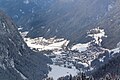 Campitello di Fassa (in front) and Fontanazzo (top right)

References
- ^ "Superficie di Comuni Province e Regioni italiane al 9 ottobre 2011". Italian National Institute of Statistics. Retrieved 16 March 2019.
- ^ "Popolazione Residente al 1° Gennaio 2018". Italian National Institute of Statistics. Retrieved 16 March 2019.
- ^ "Tav. I.5 - Appartenenza alla popolazione di lingua ladina, mochena e cimbra, per comune di area di residenza (Censimento 2001)" (PDF). Annuario Statistico 2006 (in Italian). Autonomous Province of Trento. 2007. Retrieved 2011-05-12.
- ^ All demographics and other statistics: Italian statistical institute Istat.
- v
- t
- e
- Ala
- Albiano
- Aldeno
- Altavalle
- Altopiano della Vigolana
- Amblar-Don
- Andalo
- Arco
- Avio
- Baselga di Pinè
- Bedollo
- Besenello
- Bieno
- Bleggio Superiore
- Bocenago
- Bondone
- Borgo Chiese
- Borgo d'Anaunia
- Borgo Lares
- Borgo Valsugana
- Brentonico
- Bresimo
- Caderzone Terme
- Calceranica al Lago
- Caldes
- Caldonazzo
- Calliano
- Campitello di Fassa
- Campodenno
- Canal San Bovo
- Canazei
- Capriana
- Carisolo
- Carzano
- Castel Condino
- Castel Ivano
- Castello Tesino
- Castello-Molina di Fiemme
- Castelnuovo
- Cavalese
- Cavareno
- Cavedago
- Cavedine
- Cavizzana
- Cembra Lisignago
- Cimone
- Cinte Tesino
- Cis
- Civezzano
- Cles
- Comano Terme
- Commezzadura
- Contà
- Croviana
- Dambel
- Denno
- Dimaro Folgarida
- Drena
- Dro
- Fai della Paganella
- Fiavé
- Fierozzo
- Folgaria
- Fornace
- Frassilongo
- Garniga Terme
- Giovo
- Giustino
- Grigno
- Imer
- Isera
- Lavarone
- Lavis
- Ledro
- Levico Terme
- Livo
- Lona-Lases
- Luserna
- Madruzzo
- Malè
- Massimeno
- Mazzin
- Mezzana
- Mezzano
- Mezzocorona
- Mezzolombardo
- Moena
- Molveno
- Mori
- Nago-Torbole
- Nogaredo
- Nomi
- Novaledo
- Novella
- Ospedaletto
- Ossana
- Palù del Fersina
- Panchià
- Peio
- Pellizzano
- Pelugo
- Pergine Valsugana
- Pieve Tesino
- Pieve di Bono-Prezzo
- Pinzolo
- Pomarolo
- Porte di Rendena
- Predaia
- Predazzo
- Primiero San Martino di Castrozza
- Rabbi
- Riva del Garda
- Romeno
- Roncegno Terme
- Ronchi Valsugana
- Ronzo-Chienis
- Ronzone
- Rovereto
- Roveré della Luna
- Ruffrè-Mendola
- Rumo
- Sagron Mis
- Samone
- San Giovanni di Fassa
- San Lorenzo Dorsino
- San Michele all'Adige
- Sant'Orsola Terme
- Sanzeno
- Sarnonico
- Scurelle
- Segonzano
- Sella Giudicarie
- Sfruz
- Soraga di Fassa
- Sover
- Spiazzo
- Spormaggiore
- Sporminore
- Stenico
- Storo
- Strembo
- Telve
- Telve di Sopra
- Tenna
- Tenno
- Terragnolo
- Terre d'Adige
- Terzolas
- Tesero
- Tione di Trento
- Ton
- Torcegno
- Trambileno
- Trento
- Tre Ville
- Valdaone
- Valfloriana
- Vallarsa
- Vallelaghi
- Vermiglio
- Vignola-Falesina
- Villa Lagarina
- Ville d'Anaunia
- Ville di Fiemme
- Volano
- Ziano di Fiemme

 | This Trentino-Alto Adige/Südtirol location article is a stub. You can help Wikipedia by expanding it. |
- v
- t
- e


