California Historical Landmarks in Kern County
Map all coordinates using OpenStreetMap
Download coordinates as:
- KML
- GPX (all coordinates)
- GPX (primary coordinates)
- GPX (secondary coordinates)
Properties and districts listed as California Historical Landmarks within Kern County.
- Note: Click the "Map of all coordinates" link to the right to view a Google map of all properties and districts with latitude and longitude coordinates in the table below.
Listings
| Image | [1] | Landmark name | Location | City or town | Summary |
|---|---|---|---|---|---|
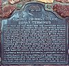 | 652 | 20 Mule Team Borax Terminus | 16246 Sierra Hwy. 35°03′24″N 118°10′31″W / 35.056767°N 118.17525°W / 35.056767; -118.17525 (20 Mule Team Borax Terminus) | Mojave | |
 | 741 | Bealville | Bealville Rd. 35°16′19″N 118°37′34″W / 35.271917°N 118.626217°W / 35.271917; -118.626217 (Bealville) | Caliente | |
 | 504 | Buena Vista Refinery | Hwy 33 & LoKern Rd. 35°23′52″N 119°39′54″W / 35.3977°N 119.665°W / 35.3977; -119.665 (Buena Vista Refinery) | McKittrick | |
 | 492 | Buttonwillow Tree | Buttonwillow Dr. 35°24′25″N 119°28′27″W / 35.406867°N 119.474217°W / 35.406867; -119.474217 (Buttonwillow Tree) | Buttonwillow | |
 | 757 | Caliente | 35°17′26″N 118°37′36″W / 35.2905°N 118.626683°W / 35.2905; -118.626683 (Caliente) | Caliente | |
 | 376 | California Standard Oil Well 1 | McKittrick Oil Field 35°17′54″N 119°38′02″W / 35.2982027777778°N 119.634011111111°W / 35.2982027777778; -119.634011111111 (California Standard Oil Well 1) | McKittrick | |
 | 742 | Campsite of Edward M. Kern | Old Isabella Road Recreation Area 35°38′58″N 118°27′30″W / 35.649583°N 118.458233°W / 35.649583; -118.458233 (Campsite of Edward M. Kern) | Lake Isabella | |
 | 382 | Colonel Thomas Baker Memorial | Bakersfield City Hall 35°22′23″N 119°01′10″W / 35.37305°N 119.019317°W / 35.37305; -119.019317 (Colonel Thomas Baker Memorial) | Bakersfield | |
 | 476 | Desert Spring | Pappas Ranch on Pappas Rd. 35°18′06″N 117°57′15″W / 35.301783°N 117.95425°W / 35.301783; -117.95425 (Desert Spring) | Cantil | |
 | 290 | Discovery well of Kern River Oilfield | Round Mountain Rd. 35°25′42″N 118°57′17″W / 35.4282°N 118.95485°W / 35.4282; -118.95485 (Discovery well of Kern River Oilfield) | Bakersfield | Appointment must be made to view. |
 | 291 | Fages-Zalvidea Crossing | State Hwy 166 35°03′33″N 119°04′00″W / 35.059233°N 119.066583°W / 35.059233; -119.066583 (Fages-Zalvidea Crossing) | Bakersfield | |
 | 129 | Fort Tejon | Fort Tejón State Historic Park 34°52′24″N 118°53′44″W / 34.873233°N 118.8955°W / 34.873233; -118.8955 (Fort Tejon) | Lebec | Also on the NRHP list as NPS-71000140 |
 | 766 | Freeman Junction | Historic district 35°36′07″N 117°54′26″W / 35.602067°N 117.907217°W / 35.602067; -117.907217 (Freeman Junction) | Inyokern | |
 | 631 | Garcés Baptismal Site | State Hwy 155 35°44′48″N 118°55′34″W / 35.746712°N 118.926144°W / 35.746712; -118.926144 (Garcés Baptismal Site) | Woody | |
 | 277 | Garcés Circle | Chester Ave & 30th St. 35°23′13″N 119°01′08″W / 35.387°N 119.019°W / 35.387; -119.019 (Garcés Circle) | Bakersfield | |
 | 671 | Site of the town of Garlock | Historic district 35°24′09″N 117°47′26″W / 35.402417°N 117.79045°W / 35.402417; -117.79045 (Site of the town of Garlock) | Randsburg | |
 | 495 | Glennville Adobe | Kern County Fire Department Glennville Substation 35°43′36″N 118°42′02″W / 35.726667°N 118.700633°W / 35.726667; -118.700633 (Glennville Adobe) | Glennville | |
| 137 | Gordon's Ferry | Kern River 35°25′29″N 118°58′05″W / 35.4248°N 118.968067°W / 35.4248; -118.968067 (Gordon's Ferry) | Bakersfield | |
 | 100 | Havilah | Miller St. & Kern River Canyon Rd. 35°31′06″N 118°30′59″W / 35.5182°N 118.5163°W / 35.5182; -118.5163 (Havilah) | Caliente | |
 | 457 | Indian Wells | Indian Wells Lodge, 2565 Aerospace Highway 35°40′04″N 117°52′20″W / 35.667867°N 117.87235°W / 35.667867; -117.87235 (Indian Wells) | Inyokern | |
 | 588 | Kern River Slough Station | Panama Rd. 35°15′35″N 118°58′03″W / 35.259722°N 118.9675°W / 35.259722; -118.9675 (Kern River Slough Station) | Lamont | |
 | 132 | Kernville | Old Kernville Cemetery, Wofford Rd. 35°43′13″N 118°26′09″W / 35.720217°N 118.435967°W / 35.720217; -118.435967 (Kernville) | Kernville | |
 | 98 | Keysville | Black Gulch Rd. 35°37′33″N 118°30′39″W / 35.625833°N 118.510833°W / 35.625833; -118.510833 (Keysville) | Lake Isabella | |
 | 485 | Lakeview Gusher | Petroleum Club Rd. 35°05′29″N 119°24′05″W / 35.091424°N 119.401377°W / 35.091424; -119.401377 (Lakeview Gusher) | Maricopa | |
 Upload Photo | 672 | Lavers' Crossing | White River & Jack Ranch rds. 35°44′10″N 118°43′13″W / 35.73605°N 118.7202°W / 35.73605; -118.7202 (Lavers' Crossing) | Glennville | |
 | 498 | McKittrick Brea Pit | State Hwy 33 and State Hwy 58 35°17′47″N 119°37′33″W / 35.296308°N 119.625881°W / 35.296308; -119.625881 (McKittrick Brea Pit) | McKittrick | |
| 589 | Mountain House | Dry Creek on Bakersfield-Glennville Rd. 35°39′52″N 118°54′58″W / 35.664455°N 118.916021°W / 35.664455; -118.916021 (Mountain House) | Woody | |
 | 97 | Oak Creek Pass | Willow Pass Rd. 35°03′40″N 118°23′19″W / 35.061117°N 118.388667°W / 35.061117; -118.388667 (Oak Creek Pass) | Tehachapi | |
 | 643 | Old Town (Tehachapi) | Old Town Rd. & Woodford-Tehachapi Rd. 35°08′35″N 118°29′40″W / 35.143056°N 118.4945°W / 35.143056; -118.4945 (Old Town (Tehachapi)) | Tehachapi | |
| 371 | Outermost point in the South San Joaquin Valley visited by Padre Garcés in 1776 | Saint Thomas the Apostle Church, 350 E. Bear Mountain Blvd. 35°12′29″N 118°49′17″W / 35.20805°N 118.821383°W / 35.20805; -118.821383 (Outermost point in the South San Joaquin Valley visited by Padre Garcés in 1776) | Arvin | Located in the courtyard of the church |
| 278 | Place where Francisco Garcés crossed the Kern River | State Hwy 178 and Rancheria Rd. 35°24′58″N 118°49′59″W / 35.416249°N 118.833187°W / 35.416249; -118.833187 (Place where Francisco Garcés crossed the Kern River) | Bakersfield | |
 | 660 | Point on the Jedediah Smith Trail | Old Bena & Tower Line Rd. 35°19′56″N 118°48′24″W / 35.332133°N 118.806583°W / 35.332133; -118.806583 (Point on the Jedediah Smith Trail) | Edison | |
| 539 | Posey Creek Station of Butterfield Overland Mail Lines | Bakersfield-Glennville Rd. & Round Mountain Rd. 35°31′50″N 118°57′41″W / 35.530469°N 118.961486°W / 35.530469; -118.961486 (Posey Creek Station of Butterfield Overland Mail Lines) | Bakersfield | |
 | 938 | Rand Mining District | Kern County Desert Museum 35°22′05″N 117°39′20″W / 35.368067°N 117.655417°W / 35.368067; -117.655417 (Rand Mining District) | Randsburg | |
 | 300 | Rose Station | Grapevine Rd. & D St. 34°56′29″N 118°55′57″W / 34.941383°N 118.932583°W / 34.941383; -118.932583 (Rose Station) | Lebec | |
| 133 | Sebastian Indian Reservation | Grapevine Rd. & D St. 34°56′28″N 118°55′57″W / 34.941°N 118.932583°W / 34.941; -118.932583 (Sebastian Indian Reservation) | Lebec | |
 | 1022 | Shafter Cotton Research Station | 17053 Shafter Avenue 35°31′57″N 119°16′41″W / 35.53245°N 119.278067°W / 35.53245; -119.278067 (Shafter Cotton Research Station) | Shafter | Also on the NRHP list as NPS-97001211 |
 | 540 | Sinks of Tejon | David and Wheeler Ridge rds. 35°05′34″N 118°54′54″W / 35.092833°N 118.91505°W / 35.092833; -118.91505 (Sinks of Tejon) | Mettler | |
 | 923 | Site of the flight of the Gossamer Condor | Shafter Airport 35°30′00″N 119°10′54″W / 35.500117°N 119.181633°W / 35.500117; -119.181633 (Site of the flight of the Gossamer Condor) | Shafter | |
 | 690 | Site of the last home of Alexis Godey | 414 19th St. 35°22′35″N 119°00′29″W / 35.376264°N 119.008042°W / 35.376264; -119.008042 (Site of the last home of Alexis Godey) | Bakersfield | |
 | 732 | Site of the home of Elisha Stevens | W. Columbus & Isla Verde sts. 35°23′50″N 119°00′21″W / 35.3973°N 119.0059°W / 35.3973; -119.0059 (Site of the home of Elisha Stevens) | Bakersfield | |
 | 508 | Tehachapi Loop | Old State Highway 35°12′03″N 118°32′13″W / 35.20085°N 118.53681°W / 35.20085; -118.53681 (Tehachapi Loop) | Tehachapi | |
 | 283 | Top of Grapevine Pass where Don Pedro Fages passed in 1772 | Lebec Rd., W side of Interstate 5, 0.2 mi. S of exit 207 34°50′03″N 118°51′56″W / 34.834111°N 118.865661°W / 34.834111; -118.865661 (Top of Grapevine Pass where Don Pedro Fages passed in 1772) | Lebec | |
 | 374 | Tulamniu Indian Site | SE of Blockhouse #BV4 | Taft | |
 | 99 | Walker's Pass | State Hwy 178 35°39′46″N 118°01′37″W / 35.662817°N 118.02685°W / 35.662817; -118.02685 (Walker's Pass) | Onyx | Also on the NRHP list as NPS-66000210 |
 | 581 | Well 2-6 | Broadway Ave 35°10′47″N 119°32′56″W / 35.1797°N 119.5489°W / 35.1797; -119.5489 (Well 2-6) | Fellows | Marker is across the street from Fellows Park |
 | 130 | Willow Springs | Manly Rd. 34°52′38″N 118°17′51″W / 34.8773°N 118.297517°W / 34.8773; -118.297517 (Willow Springs) | Rosamond |
References
- ^ "California Historical Landmarks By County". Ohp.parks.ca.gov. Retrieved 2019-04-03.
See also
Wikimedia Commons has media related to California Historical Landmarks in Kern County, California.
- List of California Historical Landmarks
- National Register of Historic Places listings in Kern County, California
- v
- t
- e
| |||||||||||||||||
National Forests and Grasslands | |||||||
|---|---|---|---|---|---|---|---|
| |||||||
|
| |||||||
| |||||||
|
|
- Heritage registers
- National Natural Landmarks


