Benning Ridge
Place in the United States
Benning Ridge | |
|---|---|
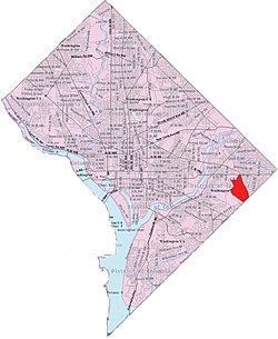 Benning Ridge within the District of Columbia | |
| Country | United States |
| District | Washington, D.C. |
| Ward | Ward 7 |
| Government | |
| • Councilmember | Vincent C. Gray |

Benning Ridge is a residential neighborhood located in Southeast Washington, D.C. It is bounded by Fort Chaplin Park to the northwest, Southern Avenue to the south, Benning Road to the east, and Ridge Road SE to the west. Benning Ridge is an unusual neighborhood for its location east of the Anacostia River: although it is surrounded by working-class and low-income African American neighborhoods, Benning Ridge is rather affluent, with a diverse population of middle- and upper-middle-class white and black residents.[1] As of 2015 the neighbourhood was one of the top ten most liberal neighbourhoods in Washington D.C..[2]
References
- ^ Brooks, Siobhan (2020). Everyday Violence against Black and Latinx LGBT Communities. Rowman & Littlefield. p. 29. ISBN 9781498575768. Retrieved 26 December 2021.
- ^ Stein, Perry (4 December 2015). "Rosslyn is most conservative and Petworth is liberal. What are the politics of your neighborhood?". The Washington Post. Retrieved 26 December 2021.
Places adjacent to Benning Ridge | ||||||||||||||||
|---|---|---|---|---|---|---|---|---|---|---|---|---|---|---|---|---|
| ||||||||||||||||


- v
- t
- e
Neighborhoods in Washington, D.C.
- Adams Morgan
- Columbia Heights
- Kalorama Triangle
- Lanier Heights
- LeDroit Park
- Meridian Hill
- Mount Pleasant
- Park View
- Pleasant Plains
- U Street Corridor (Cardozo/Shaw)
- Woodley Park
- Burleith
- Chinatown
- Downtown
- Dupont Circle
- Foggy Bottom
- Georgetown
- Sheridan-Kalorama
- Logan Circle
- Mount Vernon Square
- Penn Quarter
- Shaw
- Southwest Federal Center
- West End
- American University Park
- Berkley
- Cathedral Heights
- Chevy Chase
- Cleveland Park
- Colony Hill
- Forest Hills
- Foxhall
- Friendship Heights
- Glover Park
- Kent
- Massachusetts Heights
- McLean Gardens
- North Cleveland Park
- Observatory Circle
- The Palisades
- Potomac Heights
- Spring Valley
- Tenleytown
- Wakefield
- Wesley Heights
- Woodland Normanstone
- Woodley Park
- Barnaby Woods
- Brightwood
- Brightwood Park
- Chevy Chase
- Colonial Village
- Crestwood
- Fort Stevens Ridge
- Fort Totten
- Hawthorne
- Manor Park
- North Portal Estates
- Petworth
- Queens Chapel
- Riggs Park
- Shepherd Park
- Sixteenth Street Heights
- Takoma
- Arboretum
- Bloomingdale
- Brentwood
- Brookland
- Carver Langston
- Eckington
- Edgewood
- Fort Lincoln
- Fort Totten
- Gateway
- Ivy City
- Langdon
- Michigan Park
- North Michigan Park
- Pleasant Hill
- Queens Chapel
- Stronghold-Metropolis View
- Trinidad
- Truxton Circle
- Woodridge
- Barney Circle
- Capitol Hill
- Judiciary Square
- Mount Vernon Triangle
- Near Northeast
- NoMa
- Southwest Waterfront
- Sursum Corda
- Swampoodle
- Benning
- Benning Heights
- Benning Ridge
- Burrville
- Capitol View
- Central Northeast
- Civic Betterment
- Deanwood
- Dupont Park
- East River Heights
- Eastland Gardens
- Fairfax Village
- Fort Davis
- Fort Dupont
- Fort Stanton
- Good Hope
- Greenway
- Hillbrook
- Hillcrest
- Kenilworth
- Kingman Park
- Lincoln Heights
- Marshall Heights
- Mayfair
- Naylor Gardens
- Northeast Boundary
- Penn Branch
- Randle Highlands
- River Terrace
- Twining
- Anacostia
- Barry Farm
- Bellevue
- Buena Vista
- Congress Heights
- Douglass
- Fairlawn
- Garfield Heights
- Navy Yard
- Park Naylor
- Shipley Terrace
- Skyland
- Washington Highlands
- Woodland
38°52′57″N 76°56′18″W / 38.8824°N 76.9383°W / 38.8824; -76.9383
 | This article about a location in Washington, D.C., is a stub. You can help Wikipedia by expanding it. |
- v
- t
- e


