Beaumont, New Zealand
Settlement in Clutha District, Otago Region, New Zealand


Beaumont
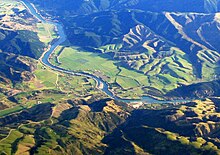
Beaumont is a small town in inland Otago, in the South Island of New Zealand. It is located on the Clutha River / Mata-Au six kilometres southeast of Raes Junction, between Roxburgh and Balclutha. Beaumont is connected to Milton and Roxburgh by State Highway 8.[1]
Beaumont was named for Beaumont Burn, probably about 1857.[2]
For eleven years, Beaumont served as the terminus of a branch line railway that ran from a junction with the Main South Line at Milton. The railway reached Beaumont in 1914; an extension to Millers Flat was opened in 1925. The line was ultimately reached Roxburgh as the Roxburgh Branch, operating until 1968.[3] Relics of the railway still remain, including a stock yard and a bridge over the Beaumont River.
Climate
| Climate data for Beaumont (1981–2010) | |||||||||||||
|---|---|---|---|---|---|---|---|---|---|---|---|---|---|
| Month | Jan | Feb | Mar | Apr | May | Jun | Jul | Aug | Sep | Oct | Nov | Dec | Year |
| Mean daily maximum °C (°F) | 21.6 (70.9) | 21.3 (70.3) | 19.3 (66.7) | 16.7 (62.1) | 12.6 (54.7) | 9.5 (49.1) | 9.1 (48.4) | 12.1 (53.8) | 14.7 (58.5) | 16.7 (62.1) | 18.5 (65.3) | 20.0 (68.0) | 16.0 (60.8) |
| Daily mean °C (°F) | 15.6 (60.1) | 15.2 (59.4) | 13.4 (56.1) | 10.8 (51.4) | 7.8 (46.0) | 4.9 (40.8) | 4.3 (39.7) | 6.4 (43.5) | 8.8 (47.8) | 10.7 (51.3) | 12.5 (54.5) | 14.2 (57.6) | 10.4 (50.7) |
| Mean daily minimum °C (°F) | 9.5 (49.1) | 9.1 (48.4) | 7.5 (45.5) | 4.9 (40.8) | 3.0 (37.4) | 0.2 (32.4) | −0.6 (30.9) | 0.7 (33.3) | 2.9 (37.2) | 4.6 (40.3) | 6.5 (43.7) | 8.5 (47.3) | 4.7 (40.5) |
| Average rainfall mm (inches) | 102.0 (4.02) | 105.7 (4.16) | 105.1 (4.14) | 70.8 (2.79) | 122.0 (4.80) | 58.5 (2.30) | 107.5 (4.23) | 66.2 (2.61) | 91.1 (3.59) | 81.2 (3.20) | 75.9 (2.99) | 94.8 (3.73) | 1,080.8 (42.56) |
| Source: NIWA[4] | |||||||||||||
References
- ^ "New Beaumont bridge design begins". Otago Daily Times. 23 June 2018. Retrieved 28 June 2021.
- ^ Reed, A.W. (2002) The Reed dictionary of New Zealand place names. Auckland: Reed Books. ISBN 0-790-00761-4.
- ^ "Story: Otago Places". Te Ara Encyclopedia of New Zealand.
- ^ "CliFlo – National Climate Database : Beaumont N.Z.F.S." NIWA. Retrieved 19 May 2024.
45°49′S 169°32′E / 45.817°S 169.533°E / -45.817; 169.533
- v
- t
- e
Clutha District, New Zealand
Seat: Balclutha
| Balclutha Ward |
|
|---|---|
| Bruce Ward | |
| Catlins Ward | |
| Clinton Ward | |
| Clutha Valley Ward | |
| Kaitangata-Matau Ward | |
| Lawrence-Tuapeka Ward |
|
| West Otago Ward |
 | This Otago geography article is a stub. You can help Wikipedia by expanding it. |
- v
- t
- e


