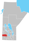
Arrow River, Manitoba
Place in Manitoba, Canada
50°8′38″N 100°53′36″W / 50.14389°N 100.89333°W / 50.14389; -100.89333 Canada
 Manitoba
R0M 2H0
Arrow River is an unincorporated community in southwestern Manitoba, Canada. It is located approximately 10 kilometers (6 miles) east of Miniota, Manitoba[2] in the Prairie View Municipality.
A post office was established on 25-13-26W in 1883 to service the settlers who had begun arriving in 1878. The Canadian Pacific railway point was also established in 1883 as was the School District, located on NE 32-13-25W. The post office was in use until 1970.[3]
External links
- Standing Stone Burial Site (Arrow River, RM of Miniota)
References
- ^ "Population and dwelling counts, for Canada and census subdivisions (municipalities), 2006 and 2001 censuses - 100% data". Statistics Canada, 2006 Census of Population. November 5, 2008. Retrieved January 30, 2009.
- ^ "Geographical Names of Canada - Querying Distances". Nrcan.gc.ca. November 15, 2011. Retrieved March 10, 2012.[permanent dead link]
- ^ Geographic Names of Manitoba (pg. 12) - the Millennium Bureau of Canada
- v
- t
- e
Division No. 15, Manitoba (Western Manitoba)
| Former towns |
|---|

| Former villages |
|---|
| Former RMs |
|---|
 | This Manitoba location article is a stub. You can help Wikipedia by expanding it. |
- v
- t
- e


