Arneytown, New Jersey
Populated place in Burlington County, New Jersey, US
Unincorporated community in New Jersey, United States
40°06′05″N 74°33′58″W / 40.10139°N 74.56611°W / 40.10139; -74.56611[1] United States
 New Jersey
Arneytown is an unincorporated community located along Province Line Road on the border of North Hanover Township in Burlington County and Upper Freehold Township in Monmouth County of New Jersey.[1][2][3] It is two miles (3.2 km) north of Jacobstown. Province Line Road was on the boundary line between the Provinces of East Jersey and West Jersey. The area was once called Upper Freehold by 18th-century Quaker settlers. With the establishment of the first post office in 1827, it became known as Arneytown.[4]
History
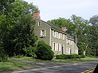
The Arneytown Tavern, also known as the Lawrie House, was built c. 1731. It was recorded as a tavern in 1762 when William Lawrie deeded it to Richard Platt.[4]
Historic district
United States historic place
Arneytown Historic District | |
 Lawrie House | |
| Location | Province Line Road (Ellisdale-Arneytown Road) and Chesterfield-Arneytown Road |
|---|---|
| Area | 58 acres (23 ha) |
| Built | 1731 (1731) |
| Architectural style | Greek Revival, Georgian |
| NRHP reference No. | 67451850[5] |
| NJRHP No. | 854[6][7] |
| Significant dates | |
| Added to NRHP | December 12, 1977 |
| Designated NJRHP | December 26, 1974 |
The Arneytown Historic District is a 58-acre (23 ha) historic district encompassing the community. It was added to the National Register of Historic Places on December 12, 1977, for its significance in architecture and community development. The district has 12 contributing buildings, including three documented individually by the Historic American Buildings Survey: Lawrie House, Duncan Mackenzie Place, and Emley-Wilde House.[4]
Cemetery
The Brigadier General William C. Doyle Veterans Memorial Cemetery is located south of the community on 225 acres (91 ha) of land. It was dedicated on May 30, 1986, by Governor Thomas Kean, and named after Doyle on January 3, 1989.[8]
Gallery
-
 Late 18th-century house

See also
- National Register of Historic Places listings in Burlington County, New Jersey
- National Register of Historic Places listings in Monmouth County, New Jersey
References
- ^ a b c d "Arneytown". Geographic Names Information System. United States Geological Survey, United States Department of the Interior.
- ^ "Locality Search". State of New Jersey.
- ^ Gannett, Henry (1894). Bulletin 118: A Geographic Dictionary of New Jersey (PDF). U.S. Government Printing Office. p. 13. doi:10.3133/b118.
- ^ a b c Israel, Nancy (August 1974). "National Register of Historic Places Inventory/Nomination: Arneytown Historic District". National Park Service. With accompanying 10 photos
- ^ "National Register Information System – (#67451850)". National Register of Historic Places. National Park Service. November 2, 2013.
- ^ "New Jersey and National Registers of Historic Places - Burlington County" (PDF). New Jersey Department of Environmental Protection - Historic Preservation Office. March 23, 2021. p. 14.
- ^ "New Jersey and National Registers of Historic Places - Monmouth County" (PDF). New Jersey Department of Environmental Protection - Historic Preservation Office. March 23, 2021. p. 18.
- ^ "BG William C. Doyle Veterans Memorial Cemetery". New Jersey Department of Military and Veterans Affairs.
External links
 Media related to Arneytown, New Jersey at Wikimedia Commons
- Historic American Buildings Survey (HABS) No. NJ-134, "Lawrie House, Arneytown, Monmouth County, NJ", 6 photos, 25 measured drawings, 4 data pages
- HABS No. NJ-202, "Duncan Mackenzie Place, Province Line Road, Arneytown, Monmouth County, NJ", 5 photos, 24 measured drawings, 7 data pages
- HABS No. NJ-303, "Emley-Wilde House, Arneytown, Monmouth County, NJ", 5 photos, 33 measured drawings, 3 data pages
- v
- t
- e
Municipalities and communities of Burlington County, New Jersey, United States
County seat: Mount Holly

- Bass River
- Bordentown
- Burlington
- Chesterfield
- Cinnaminson
- Delanco
- Delran
- Eastampton
- Edgewater Park
- Evesham
- Florence
- Hainesport
- Lumberton
- Mansfield
- Maple Shade
- Medford
- Moorestown
- Mount Holly
- Mount Laurel
- New Hanover
- North Hanover
- Pemberton
- Riverside
- Shamong
- Southampton
- Springfield
- Tabernacle
- Washington
- Westampton
- Willingboro
- Woodland
unincorporated
communities
- Arneys Mount
- Arneytown
- Atsion
- Batsto
- Beaverville
- Birmingham
- Bridgeboro
- Browns Mills Junction
- Buddtown
- Bullock
- Burrs Mill
- Chairville
- Chambers Corner
- Chatsworth
- Chesterfield
- Christopher Mills
- Clermont
- Columbus
- Comical Corner
- Cropwell
- Crossroads
- Davisville
- Eayrestown
- Ewansville
- Fellowship
- Fostertown
- Georgetown
- Green Bank
- Hartford
- Hedding
- Indian Mills
- Jacksonville
- Jacobstown
- Kinkora
- Masonville
- Mount Pleasant
- New Albany
- New Lisbon
- Rancocas
- Rancocas Woods
- Red Lion
- Retreat
- Sooy Place
- Timbuctoo
- New Jersey portal
- United States portal

| ||
|---|---|---|
| Landmarks |  | |
| Districts |
| |
| Places of worship |
| |
| Houses |
| |
| Buildings |
| |
| Sites |
| |

Authority control databases | |
|---|---|
| International |
|
| National |
|


