A4226 road
Road in the Vale of Glamorgan
 | |
|---|---|
 | |
 | |
| Major junctions | |
| North end | Bonvilston |
| Major intersections |  A48 A48 A4050 A4050 |
| South end | Cardiff International Airport |
| Location | |
| Country | United Kingdom |
| Constituent country | Wales |
| Road network | |
The A4226 (better known as The Five Mile Lane) is a main road linking Bonvilston to Barry and Cardiff International Airport (CIA) in the Vale of Glamorgan, Wales.
Road course
First stage

The A4226 begins at the junction with the A48 road (Sycamore Cross) just east of Bonvilston and south of Gwern-y-Steeple and Peterston-Super-Ely. It heads in a southerly direction past numerous farms and country lanes leading off to hamlets such as Llancadle, Moulton, Walterston and Dyffryn Gardens etc., past the Welsh Hawking Centre until the junction with Port Road (leading to the A4050 road at Colcot roundabout) at Weycock Cross in northwestern Barry.
The Five Mile Lane
This initial stage of the road is widely known locally as The Five Mile Lane, in fact it is nearer 4 miles today but historically the road extended along what is now Pontypridd Road in Barry to Romilly, roughly 5 miles in total.
Second stage


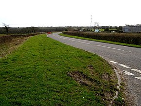
Left: Heading west to Cardiff International Airport. Right: Heading east outside Cwm Ciddi inn on the outskirts of Barry, approaching the roundabout at Weycock Cross.
However, the A4226 route forks some 120 degrees at Weycock Cross to the right as one approaches the roundabout, where it continues in a westerly direction (continuation of Port Road West) along the northern perimeter of the airport until the entrance to the airport at the Tredogan roundabout. At this roundabout it becomes the B4265 road which leads to Llantwit Major and eventually to Bridgend and the turn off to the north leads to Penmark.
Maintenance
On 1 July 1970, the Weycock section of the road was formally upgraded to Principal Road Status after being widened and improved.[1] There is currently a proposal to upgrade this road to improve access to CIA. The improvements include adding straighter sections and other works to increase speeds along the road, and to extend the route designation to include the road between Sycamore Cross and the M4 Motorway Junction 34 (Miskin). The extension would also have upgrades including straighter sections to allow for faster speeds.[1]
References
Wikimedia Commons has media related to A4226 road (Wales).
- ^ Roads and road construction: a monthly record of road engineering and development. Carriers Pub. Co. 1971.
- v
- t
- e
- Barry
- template
- Cowbridge
- Llantwit Major
- Penarth

- Barry
- Colwinston
- Cowbridge with Llanblethian
- Dinas Powys
- Ewenny
- Llanmaes
- Llancarfan
- Llandough
- Llandow
- Llanfair
- Llangan
- Llantwit Major
- Michaelston-le-Pit and Leckwith
- Penarth
- Pendoylan
- Penllyn
- Peterston-super-Ely
- Rhoose
- St Athan
- St Bride's Major
- St Donats
- St Georges-super-Ely
- St Nicholas and Bonvilston
- Sully and Lavernock
- Welsh St Donats
- Wenvoe
- Wick
- Aberthaw
- Aberthin
- Broughton
- Bonvilston
- Boverton
- Boys Village
- Clawdd Coch
- Clemenstone
- Colwinston
- Corntown
- Culverhouse Cross
- Dinas Powys
- Downs
- Drope
- Dyffryn
- Eglwys Brewis
- Ewenny
- Flemingston
- Fonmon
- Font-y-Gary
- Frampton
- Gileston
- Goldsland
- Graig Penllyn
- Great Hamston
- Gwern-y-Steeple
- Kenson
- Lavernock
- Lidmore
- Llampha
- Llanmaes
- Llanbethery
- Llanblethian
- Llancadle
- Llancarfan
- Llandough (near Cowbridge)
- Llandough (near Penarth)
- Llandow
- Llangan
- Llanmihangel
- Llansannor
- Llantrithyd
- Llantwithyn
- Llysworney
- Maendy
- Marcross
- Michaelston-le-Pit
- Middlecross
- Moulton
- Newton
- Northcliff
- Nurston
- Ogmore
- Ogmore-by-Sea
- Pancross
- Pendoylan
- Penmark
- Pentre Meyrick
- Peterston-super-Ely
- Pen-y-Lan
- Picketston
- Prisk
- Rhoose
- Sigingstone
- St Andrews Major
- St Brides Major
- Southerndown
- St Athan
- St Donats
- St Georges super Ely
- St Hilary
- St Mary Church
- St Mary Hill
- St Nicholas
- St Lythans
- Sully
- Sutton
- The Herberts
- Tre-Aubrey
- Tredodridge
- Treguff
- Trerhyngyll
- Twyn-yr-Odyn
- Walterston
- Wenvoe
- Wick
- Wrinstone
- Ystradowen
listed buildings
| Grade I | |
|---|---|
| Grade II* |
- Breaksea Point
- East Aberthaw Coast
- Collugh Beach
- Sully Island
- Tresilian Bay
- Afon Alun
- Afon Col-huw
- Cadoxton River
- Ewenny River
- Nant y Stepsau
- River Kenson
- River Thaw
- River Waycock
- Schools
- SSSIs
- Scheduled Monuments
- Registered parks and gardens
- Lord Lieutenants
- High Sheriffs
- Country houses
- Museums
- Books
- Public art
 Geography
 Wales
Wales Category


A roads in Zone 4 of the Great Britain road numbering scheme | ||
|---|---|---|
 | ||
| ||
| ||
51°25′49″N 3°19′26″W / 51.4304°N 3.3238°W / 51.4304; -3.3238


