La Bazoche-Gouet
| La Bazoche-Gouet | ||
|---|---|---|
 |
| |
| Staat | Frankreich | |
| Region | Centre-Val de Loire | |
| Département (Nr.) | Eure-et-Loir (28) | |
| Arrondissement | Nogent-le-Rotrou | |
| Kanton | Brou | |
| Gemeindeverband | Grand Châteaudun | |
| Koordinaten | 48° 8′ N, 0° 59′ O48.1386111111110.98055555555556Koordinaten: 48° 8′ N, 0° 59′ O | |
| Höhe | 164–229 m | |
| Fläche | 37,44 km² | |
| Einwohner | 1.215 (1. Januar 2021) | |
| Bevölkerungsdichte | 32 Einw./km² | |
| Postleitzahl | 28330 | |
| INSEE-Code | 28027 | |
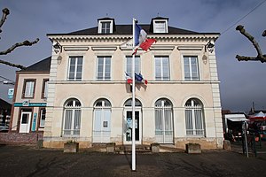 Mairie La Bazoche-Gouet | ||


La Bazoche-Gouet ist eine französische Gemeinde mit 1215 Einwohnern (Stand 1. Januar 2021) im Département Eure-et-Loir in der Region Centre-Val de Loire; sie gehört zum Arrondissement Nogent-le-Rotrou und zum Kanton Brou.
Bevölkerungsentwicklung
- 1962: 1463
- 1968: 1529
- 1975: 1451
- 1982: 1311
- 1990: 1281
- 1999: 1249
- 2012: 1263
Persönlichkeiten
- Emma Valladon (1837–1913), Sängerin „Thérésa“
- Adrien Philippe (1815–1894), Uhrmacher und Erfinder

Weblinks
Commons: La Bazoche-Gouet – Sammlung von Bildern, Videos und Audiodateien


